
A polder is a low-lying tract of land that forms an artificial hydrological entity, enclosed by embankments known as dikes. The three types of polder are:
- Land reclaimed from a body of water, such as a lake or the seabed
- Flood plains separated from the sea or river by a dike
- Marshes separated from the surrounding water by a dike and subsequently drained; these are also known as koogs, especially in Germany

The Halvergate Marshes are an area of grazing marsh in the east of the English county of Norfolk. They form part of the area of The Broads and lie between the River Bure and the River Yare, bordering Breydon Water on the east. The marshes cover an area of around 2,642 hectares An area of 1,432.7-hectare (3,540-acre) is a biological Site of Special Scientific Interest. Some areas are also in the Breydon Water Local Nature Reserve, the Broadland and Breydon Water Ramsar sites, The Broads Special Area of Conservation, and The Broads and Breydon Water Special Protection Areas.

Berney Marshes and Breydon Water RSPB reserve is a nature reserve managed by the Royal Society for the Protection of Birds (RSPB). Berney Marshes is situated south of the River Bure while Breydon water is the combined estuary of the River Waveney and the River Yare inland from Great Yarmouth in Norfolk, England.

The River Stour(, rhymes with "flour") is a river in Kent, England that flows into the North Sea at Pegwell Bay. Above Plucks Gutter, where the Little Stour joins it, the river is normally known as the Great Stour. The upper section of the river, above its confluence with the East Stour at Ashford is sometimes known as the Upper Great Stour or West Stour. In the tidal lower reaches, the artificial Stonar Cut short cuts a large loop in the natural river.

Ouse Washes is a linear 2,513.6-hectare (6,211-acre) biological Site of Special Scientific Interest stretching from near St Ives in Cambridgeshire to Downham Market in Norfolk. It is also a Ramsar internationally important wetland site, a Special Protection Area for birds, a Special Area of Conservation and a Nature Conservation Review site, Grade I. An area of 186 hectares between March and Ely is managed by the Wildlife Trust for Bedfordshire, Cambridgeshire and Northamptonshire and another area near Chatteris is managed by the Royal Society for the Protection of Birds. The Wildfowl & Wetlands Trust manages another area near Welney.
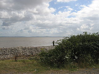
Bridgwater Bay is on the Bristol Channel, 5 kilometres (3.1 mi) north of Bridgwater in Somerset, England at the mouth of the River Parrett and the end of the River Parrett Trail. It stretches from Minehead at the southwestern end of the bay to Brean Down in the north. The area consists of large areas of mudflats, saltmarsh, sandflats and shingle ridges, some of which are vegetated. It has been designated as a Site of Special Scientific Interest (SSSI) covering an area of 3,574.1 hectares since 1989, and is designated as a wetland of international importance under the Ramsar Convention. The risks to wildlife are highlighted in the local Oil Spill Contingency Plan.

Romney Marsh is a sparsely populated wetland area in the counties of Kent and East Sussex in the south-east of England. It covers about 100 square miles (260 km2). The Marsh has been in use for centuries, though its inhabitants commonly suffered from malaria until the 18th century. Due to its location, geography and isolation, it was a smuggler's paradise between the 1600s and 1800s. The area has long been used for sheep pasture: Romney Marsh sheep are considered one of the most successful and important sheep breeds. Criss-crossed with numerous waterways, and with some areas lying below sea level, the Marsh has over time sustained a gradual level of reclamation, both through natural causes and by human intervention.

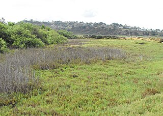
A salt marsh, salt marsh or salting, also known as a coastal salt marsh or a tidal marsh, is a coastal ecosystem in the upper coastal intertidal zone between land and open saltwater or brackish water that is regularly flooded by the tides. It is dominated by dense stands of salt-tolerant plants such as herbs, grasses, or low shrubs. These plants are terrestrial in origin and are essential to the stability of the salt marsh in trapping and binding sediments. Salt marshes play a large role in the aquatic food web and the delivery of nutrients to coastal waters. They also support terrestrial animals and provide coastal protection.

Blacktoft Sands RSPB reserve is a nature reserve in the East Riding of Yorkshire, England. It is managed by the Royal Society for the Protection of Birds, which leases the site from Associated British Ports.

wiki 51°30′N0°35′E

Montrose Basin is a nearly circular tidal basin which makes up part of the estuary of the River South Esk and which sits just inland of the town of Montrose in Angus on the east coast of Scotland. The basin is protected by a number of designations, it is managed by the Scottish Wildlife Trust as a Wildlife Reserve, as well as being designated as a Local Nature Reserve, Site of Special Scientific Interest, a Special Protection Area and a Ramsar Site.

A reedbed or reed bed is a natural habitat found in floodplains, waterlogged depressions and estuaries. Reedbeds are part of a succession from young reeds colonising open water or wet ground through a gradation of increasingly dry ground. As reedbeds age, they build up a considerable litter layer that eventually rises above the water level and that ultimately provides opportunities in the form of new areas for larger terrestrial plants such as shrubs and trees to colonise.

A tidal marsh is a marsh found along rivers, coasts and estuaries which floods and drains by the tidal movement of the adjacent estuary, sea or ocean. Tidal marshes experience many overlapping persistent cycles, including diurnal and semi-diurnal tides, day-night temperature fluctuations, spring-neap tides, seasonal vegetation growth and decay, upland runoff, decadal climate variations, and centennial to millennial trends in sea level and climate.

Located in northern California, the Suisun Marsh has been referred to as the largest brackish water marsh on west coast of the United States of America. The marsh land is part of the San Francisco Bay tidal estuary, and subject to tidal ebb and flood. The marsh is home to many species of birds and other wildlife, and is formed by the confluence of the Sacramento and San Joaquin rivers between Martinez and Suisun City, California and several other smaller, local watersheds. Adjacent to Suisun Bay, the marsh is immediately west of the legally defined Sacramento-San Joaquin Delta as well as part of the San Francisco Bay estuary.
A tidal river is a river whose flow and level are caused by tides. A section of a larger river affected by the tides is a tidal reach, but it may sometimes be considered a tidal river if it had been given a separate and another title name.

Oare Marshes is a 71.4-hectare (176-acre) Local Nature Reserve north of Faversham in Kent. It is owned and managed by Kent Wildlife Trust. It is part of The Swale Nature Conservation Review site, Grade I, National Nature Reserve, Ramsar internationally important wetland site, Special Protection Area under the European Union Directive on the Conservation of Wild Birds, and Site of Special Scientific Interest.

Blake's Pools are a 4 hectare nature reserve owned by Environment Agency and leased by the Avon Wildlife Trust, on the banks of the Congresbury Yeo close to its mouth, near Kingston Seymour, Somerset, in South West England.
Brackish marshes develop from salt marshes where a significant freshwater influx dilutes the seawater to brackish levels of salinity. This commonly happens upstream from salt marshes by estuaries of coastal rivers or near the mouths of coastal rivers with heavy freshwater discharges in the conditions of low tidal ranges.
Classification of wetlands has been a problematical task, with the commonly accepted definition of what constitutes a wetland being among the major difficulties. A number of national wetland classifications exist. In the 1970s, the Ramsar Convention on Wetlands of International Importance introduced a first attempt to establish an internationally acceptable wetland classification scheme.

Hurst Castle and Lymington River Estuary is a 1,077.3-hectare (2,662-acre) biological and geological Site of Special Scientific Interest near Lymington in Hampshire. It is a Nature Conservation Review site and two areas are Geological Conservation Review sites. Three areas are local nature reserves, Boldre Foreshore, Sturt Pond and Lymington and Keyhaven Marshes; the latter site is managed by the Hampshire and Isle of Wight Wildlife Trust. Part of it is North Solent National Nature Reserve. It is part of Solent and Southampton Water Ramsar site and Special Protection Area. Parts of it are in Solent Maritime and Solent and Isle of Wight Lagoons Special Areas of Conservation.