Fobbing

Last updated

Fobbing
The Tower, St Michaels Church, Fobbing - geograph.org.uk - 1066780.jpg
Tower of St Michael's Church
Essex UK location map.svg
Red pog.svg
Fobbing
Location within Essex
OS grid reference TQ715845
Unitary authority
Shire county
Region
Country England
Sovereign state United Kingdom
Post town Stanford-le-Hope
Postcode district SS17 9
Police Essex
Fire Essex
Ambulance East of England
UK Parliament
List of places
UK
England
Essex
51°32′02″N0°28′27″E / 51.53395°N 0.474129°E / 51.53395; 0.474129 Coordinates: 51°32′02″N0°28′27″E / 51.53395°N 0.474129°E / 51.53395; 0.474129

Fobbing is a small village and former civil parish in Thurrock, Essex, England and one of Thurrock's traditional (Church of England) parishes. It is located between Basildon and Corringham, and is also close to Stanford-le-Hope. In 1931 the parish had a population of 734. [1]

Contents

Fobbing is one of seven conservation areas in Thurrock. [2]

History

The place-name Fobbing is first attested in the Domesday Book of 1086, where it appears as Phobinge. It appears as Fobinges in 1125, and Fobbinges in 1227. The name means "Fobba's people", Fobba being a shortened form of the name Folcheorht. [3]

Fobbing was one of the main villages involved with the Peasants' Revolt. On 30 May 1381, the commissioner John Bampton summoned the Fobbing villagers, as well as villagers from Corringham and Stanford, to Brentwood to answer as to why they had not paid tax. The villagers told Bampton that they would give him nothing. Bampton then moved to arrest the villagers. A riot ensued in which the villagers attempted to kill Bampton, who managed to escape to London. Sir Robert Belknap was sent to investigate the incident and to punish the offenders. On 2 June, he was attacked. By this time the violent discontent had spread, and the counties of Essex and Kent were in full revolt. Soon people moved on London in an armed uprising. [4] [5] In 1981 a metal sculpture by B R Coode-Adams was erected as a memorial to the Peasants' Revolt at Fobbing to commemorate the 600th anniversary .

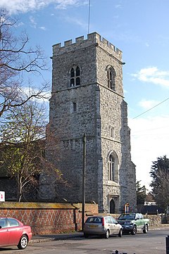
St. Michael's Church is renowned for its historic association with the smuggling trade. At one time the church was near the waterfront of Fobbing Harbour. Smugglers sailed up Fobbing Creek guided by the distinctive church tower but after the great flood of 1 February 1953, the creek and harbour were sealed up by a dyke and drained. Underneath the church there are claimed to be many tunnels which were used by smugglers in the 14th century.

On 1 April 1936 the parish was abolished to form Thurrock, part also went to Lee Chapel. [6]

Public house

The White Lion White lion fobbing.jpg
The White Lion

The White Lion public house is situated at the top of Lion Hill.

Notable people

Notes

  1. "Population statistics Fobbing CP/AP through time". A Vision of Britain through Time . Retrieved 24 December 2021.
  2. Thurrock Council | Natural & Historic Environment | Conservation Areas In Thurrock Archived 10 February 2009 at the Wayback Machine
  3. Eilert Ekwall, The Concise Oxford Dictionary of English Place-names, p.183.
  4. Maurice Hugh Keen, England in the Later Middle Ages: a political history (Routledge, 1975)
  5. Dedman, M., 2012. Peasants were revolting - and they did it right here. Brentwood Gazette, 6 Jun. p. 20.
  6. "Relationships and changes Fobbing CP/AP through time". A Vision of Britain through Time. Retrieved 24 December 2021.

Related Research Articles

Thurrock Borough & Unitary authority area in England

Thurrock is a unitary authority area with borough status in the English ceremonial county of Essex. It is part of the London commuter belt and an area of regeneration within the Thames Gateway redevelopment zone. The local authority is Thurrock Council.

Aveley Human settlement in England

Aveley is a town and former civil parish in the unitary authority of Thurrock in Essex, England, and forms one of the traditional Church of England parishes. Aveley is 16 miles (26.2 km) east of Charing Cross. In 2019 it had an estimated population of 9,461. In 1931 the parish had a population of 2003.

South Ockendon Human settlement in England

South Ockendon is a town, former civil parish and Church of England parish within the Thurrock borough in Essex in the East of England, United Kingdom. It is located on the border with Greater London, just outside the M25 motorway. The area to the north is North Ockendon. In 2019 it had an estimated population of 22,303. In 1931 the parish had a population of 1355.

West Thurrock Human settlement in England

West Thurrock is an area, former civil parish and traditional Church of England parish and town in Thurrock, Essex, England, located 17.5 miles (28.1 km) east south-east of Charing Cross, London. In 1931 the parish had a population of 5153. On 1 April 1936 the parish was abolished to form Thurrock.

Stanford-le-Hope Human settlement in England

Stanford-le-Hope is a town, former civil parish and Church of England parish situated in the county of Essex, England. Often known locally simply as Stanford, the town is within the unitary authority of Thurrock and located 23.8 miles (38.4 km) east of Charing Cross in London. In 1931 the parish had a population of 4311.

Childerditch Human settlement in England

Childerditch is a settlement and former civil parish now in the unparished area of Brentwood, in the Brentwood district, in the county of Essex, England. It forms part of the Warley borough council ward. In 1931 the parish had a population of 184. On 1 April 1934 the parish was abolished and merged with Brentwood, part also went to Little Burstead.

East Horndon Human settlement in England

East Horndon is a village and former civil parish, now in the parish of West Horndon, in the south of the borough of Brentwood in Essex in the East of England. It is situated just south of the A127 road near Herongate. The village Church of All Saints is located to the north of the A127, and is redundant, but in the care of the Churches Conservation Trust. In 1931 the parish had a population of 440.

Little Warley Human settlement in England

Little Warley is a village and former civil parish, now in the unparished area of Brentwood, in the Brentwood district, in the county of Essex, England. It is situated south of Thorndon Country Park. In 1931 the parish had a population of 395. On 1 April 1934 the parish was abolished and merged with Brentwood, part also went to Little Burstead.

South Basildon and East Thurrock (UK Parliament constituency) Parliamentary constituency in the United Kingdom, 2010 onwards

South Basildon and East Thurrock is a constituency represented in the House of Commons of the UK Parliament since its 2010 creation by Stephen Metcalfe, a Conservative.

Bulphan Human settlement in England

Bulphan is a village and former civil parish in the borough of Thurrock in the East of England and one of the traditional parishes in Thurrock. In 2019 it had an estimated population of 1028. In 1931 the parish had a population of 455.

Thurrock Urban District

Thurrock was a local government district and civil parish in south Essex, England from 1936 to 1974.

Orsett Rural District was the local government district centred on Orsett in south Essex, England from 1894 to 1936; a little of its far west is in modern Greater London. Likewise in modern terms the area is mostly east of the M25 motorway and north of the Thames Estuary. It was formed in 1894. Housing quite few residents, it gradually fell from 62.4 to 49.6 square miles. Its notable omission was Grays or Great Thurrock; Thurrock was the main successor district.

Orsett Human settlement in England

Orsett is a village, former civil parish and ecclesiastical parish located within Thurrock unitary district in Essex, England, situated around 5 km north-east of Grays. In 1931 the parish had a population of 1771.

Mucking Hamlet in Essex, England

Mucking is a hamlet and former Church of England parish adjoining the Thames Estuary in southern Essex, England. It is located approximately 2 miles (3.2 km) south of the town of Stanford-le-Hope in what is now Thurrock unitary authority. In 1931 the parish had a population of 498.

Corringham, Essex Human settlement in England

Corringham is an English town and former civil parish, located on a hill overlooking the River Thames east of London. It is situated 7 miles from Tilbury, and lies between Canvey Island and Tilbury Fort. Its commercial centre in smaller Stanford-le-Hope immediately to its south-west. It is in the unitary authority of Thurrock and a traditional parish stretching from Horseshoe Bay in the Thames Estuary to Dry Street, south of Langdon Hills. It is in the far east of the borough. In 1931 the parish had a population of 1897.

Langdon Hills is a township and former civil parish located in Basildon in Essex, England.

Thomas Baker, an English landowner, was one of the leaders who initiated the Peasants' Revolt of 1381.

Brentwood, Essex Human settlement in England

Brentwood is a town in the Borough of Brentwood, in the county of Essex in the East of England. It is in the London commuter belt, situated 20 miles (30 km) east-north-east of Charing Cross and close by the M25 motorway. In 2017, the population of the town was estimated to be 54,885.

Horndon-on-the-Hill Human settlement in England

Horndon on the Hill is a village, former civil parish and Church of England parish in the unitary authority of Thurrock, in the county of Essex, England. It is located close to the A13, around one mile northwest of Stanford-le-Hope and around two miles northeast of Orsett. The village area falls within the Orsett ward of Thurrock District Council. In 2019 it had an estimated population of 1517. In 1931 the parish had a population of 1052.

Stifford Human settlement in England

Stifford is an area and former civil parish in the unitary authority of Thurrock, Essex, England. The traditional parish of Stifford is divided by the A13 trunk road into two communities known respectively as North and South Stifford. In 1931 the parish had a population of 2188. On 1 April 1936 the parish was abolished to form Thurrock.