Vatluru

Last updated

Vatluru
village
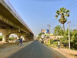
Vatluru Flyover.jpg
Vatluru Flyover Under Construction
Location map India Andhra Pradesh EN.svg
Red pog.svg
Vatluru
Location in Andhra Pradesh, India
India location map.svg
Red pog.svg
Vatluru
Vatluru (India)
Coordinates: 16°29′43″N81°18′40″E / 16.4954°N 81.3112°E / 16.4954; 81.3112 Coordinates: 16°29′43″N81°18′40″E / 16.4954°N 81.3112°E / 16.4954; 81.3112
Country India
State Andhra Pradesh
District West Godavari
Government
  Body Gram Panchayat
Population
 (2011) [1]
  Total14,368
Languages
  Official Telugu
Time zone UTC+5:30 (IST)
PIN
534007

Vatluru is a village in West Godavari district of the Indian state of Andhra Pradesh. It is located in Pedapadu mandal.

West Godavari district District of Andhra Pradesh in India

West Godavari district or Paschima Godavari Jilla is one of the 13 districts in the Indian state of Andhra Pradesh. The district is situated in Coastal Andhra region of the state. The administrative headquarters of the district is situated at Eluru. As of 2011 census of India, the district has an area of 7,742 km2 (2,989 sq mi) and a population of 3,936,966. It is bounded by Krishna district on the west, East Godavari district on the east, Bay of Bengal on the south and the state of Telangana on the north.

India Country in South Asia

India, also known as the Republic of India, is a country in South Asia. It is the seventh-largest country by area, the second-most populous country, and the most populous democracy in the world. Bounded by the Indian Ocean on the south, the Arabian Sea on the southwest, and the Bay of Bengal on the southeast, it shares land borders with Pakistan to the west; China, Nepal, and Bhutan to the northeast; and Bangladesh and Myanmar to the east. In the Indian Ocean, India is in the vicinity of Sri Lanka and the Maldives; its Andaman and Nicobar Islands share a maritime border with Thailand and Indonesia.

Andhra Pradesh State in southern India

Andhra Pradesh is one of the 29 states of India. Situated in the south-east of the country, it is the seventh-largest state in India, covering an area of 160,205 km2 (61,855 sq mi). As per the 2011 census, it is the tenth-most populous state, with 49,386,799 inhabitants. The largest city in Andhra Pradesh is Visakhapatnam. Telugu, one of the classical languages of India, is the major and official language of Andhra Pradesh.

Contents

Demographics

As of 2011 Census of India, Vatluru had a population of 14,368. The total population constitute, 6,780 males and 7,588 females —a sex ratio of 1119 females per 1000 males. 1,077 children are in the age group of 0–6 years, of which 528 are boys and 549 are girls. The average literacy rate stands at 85.80% with 11,403 literates. [1]

The decennial Census of India has been conducted 15 times, as of 2011. While it has been undertaken every 10 years, beginning in 1872, the first complete census was taken in 1881. Post 1949, it has been conducted by the Registrar General and Census Commissioner of India under the Ministry of Home Affairs, Government of India. All the censuses since 1951 were conducted under the 1948 Census of India Act. The last census was held in 2011. The next will be held in 2021.

Transport

Vatluru is well connected by road. APS RTC busses from Eluru, Vijayawada, Machilipatnam and Hanuman Junction stops here. Vatluru railway station serves Vatluru. It has halt to passenger services. Eluru railway station is the nearest major railway station. Vatluru Railgate is well known for traffic. [2]

Eluru City in Andhra Pradesh, India

Eluru is a city and the district headquarters of West Godavari district in the Indian state of Andhra Pradesh. It is one of the 14 municipal corporations in the state and the mandal headquarters of Eluru mandal in the Eluru revenue division. The city is on the Tammileru river. The city is well known for its wool-pile carpets and hand woven products. As of 2011 Census of India, the city had a population of 217,876. Its history dates back to the second century CE.

Vijayawada Metropolis in Andhra Pradesh, India

Vijayawada is a city on the banks of Krishna River, in Krishna district of the Indian state of Andhra Pradesh. It is one of the twelve urban local bodies in the Andhra Pradesh Capital Region. The city is the second largest city in the state by population and third most densely populated urban built-up areas in the world. Vijayawada is often referred as the Commercial capital of Andhra Pradesh and is classified as a Y-grade city by the Sixth Central Pay Commission. The city is the second most populous in the state with a population of more than one million. It was recognised as a "Global City of the Future" by McKinsey Quarterly, which expected an increase to GDP of $17 billion by 2025. In October 2018, it was awarded with ISO 37120 platinum level certification and has been added to the "Global Cities Registry".

Machilipatnam City in Andhra Pradesh, India

Machilipatnam, also known as Masulipatnam and Bandar, is a town in Krishna district of the Indian state of Andhra Pradesh. It is a municipal corporation and the administrative headquarters of Krishna district. It is also the mandal headquarters of Machilipatnam mandal in Machilipatnam revenue division of the district. The ancient port town served as the settlement of European traders from the 16th century, and it was a major trading port for the British, Dutch and French in the seventeenth century.

Related Research Articles

Tadepalligudem city in Andhra Pradesh, India

Tadepalligudem (TPG) is a city in West Godavari district of the Indian state of Andhra Pradesh. It is a municipality and the mandal headquarters of Tadepalligudem mandal in Eluru revenue division.

Bhimadole Village in Andhra Pradesh, India

Bhimadole is a village in Bhimadole mandal of West Godavari district of the Indian state of Andhra Pradesh.

Peda Avutapalli Town in Andhra Pradesh, India

Peda Avutapalli is a developing town in Unguturu mandal, Krishna district, Andhra Pradesh, India. It is located 7.5 km from the Vijayawada Airport. Comes under Gannavaram constituency, Current MLA Dr.Vallabhaneni Vamsi Mohan(TDP).

Chataparru Village in Andhra Pradesh, India

Chataparru is a village in Eluru mandal of West Godavari district, Andhra Pradesh, India. Veteran Telugu film producer Vijaya Bapineedu and Telugu film actor Murali Mohan were born in this village. Government of Andhra Pradesh selected this village as Smart Village.

Eluru mandal Mandal in Andhra Pradesh, India

Eluru mandal is one of the 46 mandals in West Godavari district of the Indian state of Andhra Pradesh. It is administered under Eluru revenue division and its headquarters are located at Eluru city. The mandal is bounded by Pedapadu mandal, Pedavegi mandal, Denduluru mandal, Bhimadole mandal and it also borders Krishna district.
Tangellamudi Census Town in Andhra Pradesh, India

Tangellamudi is a census town in West Godavari district of the Indian state of Andhra Pradesh. It is located in Eluru mandal of Eluru revenue division. The town is a constituent of Eluru urban agglomeration.

Gavaravaram Census Town in Andhra Pradesh, India

Gavaravaram is a census town in West Godavari district of the Indian state of Andhra Pradesh. It is located in Eluru mandal of Eluru revenue division. The town is a constituent of Eluru urban agglomeration.

Satrampadu Census Town in Andhra Pradesh, India

Satrampadu is a census town in West Godavari district of the Indian state of Andhra Pradesh. It is located in Eluru mandal of Eluru revenue division. The town is a constituent of Eluru urban agglomeration.

Sanivarapupeta Census Town in Andhra Pradesh, India

Sanivarapupeta is a census town in West Godavari district of the Indian state of Andhra Pradesh. It is located in Eluru mandal of Eluru revenue division. The town is a constituent of Eluru urban agglomeration.

Denduluru Village in Andhra Pradesh, India

Denduluru is a village in the West Godavari district of the Indian state of Andhra Pradesh. It is located on the north-east side of district headquarters Eluru at a distance of 11 km. It is a member of the Eluru revenue division. The Bhimalingadibba or the mounds are one of the centrally protected monuments of national importance.It is the birth place of indians famous celebrity bhanu

Pedapadu mandal Mandal in Andhra Pradesh, India

Pedapadu mandal is one of the 46 mandals in West Godavari district of the Indian state of Andhra Pradesh having population of 76,793 as of 2011 census. It is administered under Eluru revenue division and its headquarters are located at Pedapadu.

Mupparru Village in Andhra Pradesh, India

Mupparru is a village in Pedapadu mandal of West Godavari district of the Indian state of Andhra Pradesh. It is located at a distance of 5 km from Eluru New bus station.

Komadavole Out Growth in Andhra Pradesh, India

Komadavole is a out growth of Eluru city in West Godavari district of the Indian state of Andhra Pradesh. It is located in Eluru mandal of Eluru revenue division. It is also a constituent of Eluru Urban Agglomeration.

Chodimella Village in Andhra Pradesh, India

Chodimella is a village in West Godavari district of the Indian state of Andhra Pradesh. It is located in Eluru mandal of Eluru revenue division. The town is a constituent of Eluru urban agglomeration.

Jalipudi Village in Andhra Pradesh, India

Jalipudi is a village in West Godavari district of the Indian state of Andhra Pradesh. It is located in Eluru mandal of Eluru revenue division. The town is a constituent of Eluru urban agglomeration.

Madepalle Village in Andhra Pradesh, India

Madepalle is a village in West Godavari district of the Indian state of Andhra Pradesh. It is located in Eluru mandal of Eluru revenue division. The town is a constituent of Eluru urban agglomeration.

Malkapuram, West Godavari Village in Andhra Pradesh, India

Malkapuram is a village in West Godavari district of the Indian state of Andhra Pradesh. It is located in Eluru mandal of Eluru revenue division. The town is a constituent of Eluru urban agglomeration.

Unguturu mandal, West Godavari district Mandal in Andhra Pradesh, India

Unguturu mandal is one of 46 mandals in the West Godavari district of the Indian state of Andhra Pradesh. The headquarters are located at Unguturu town. The mandal is bordered by Tadepalligudem mandal and Pentapadu mandal to the north, Nallajerla mandal to the west, Nidamarru mandal to the east, and by Dwaraka Tirumala mandal and Bhimadole mandal to the south

Pentapadu mandal Mandal in Andhra Pradesh, India

Pentapadu mandal is one of 46 mandals in the West Godavari district of the Indian state of Andhra Pradesh.
References

  1. 1 2 "Census 2011". The Registrar General & Census Commissioner, India. Retrieved 26 July 2014.
  2. "Works on RoB at Vatluru gets under way".