Vera, Mato Grosso

Last updated
Vera
Municipality
Vera Brasao.png
MatoGrosso Municip Vera.svg
CountryFlag of Brazil.svg  Brazil
Region Center-West
State Mato Grosso
MesoregionNorte Mato-Grossense
Population
 (2020 [1] )
  Total11,402
Time zone UTC−3 (BRT)

Vera is a municipality in the state of Mato Grosso in the Central-West Region of Brazil. [2] [3] [4] [5]

Contents

Climate

Climate data for Gleba Celeste (Vera), Mato Grosso, elevation 415 m (1,362 ft), (1981–2010)
MonthJanFebMarAprMayJunJulAugSepOctNovDecYear
Mean daily maximum °C (°F)31.8
(89.2)
32.0
(89.6)
32.3
(90.1)
33.1
(91.6)
32.9
(91.2)
33.1
(91.6)
33.3
(91.9)
35.1
(95.2)
35.0
(95.0)
34.1
(93.4)
32.8
(91.0)
31.8
(89.2)
33.1
(91.6)
Daily mean °C (°F)25.1
(77.2)
25.2
(77.4)
25.4
(77.7)
25.7
(78.3)
24.8
(76.6)
23.6
(74.5)
23.2
(73.8)
24.7
(76.5)
26.0
(78.8)
26.2
(79.2)
25.7
(78.3)
25.3
(77.5)
25.1
(77.2)
Mean daily minimum °C (°F)21.3
(70.3)
21.2
(70.2)
21.3
(70.3)
20.9
(69.6)
19.0
(66.2)
16.8
(62.2)
15.8
(60.4)
17.2
(63.0)
19.7
(67.5)
21.2
(70.2)
21.5
(70.7)
21.5
(70.7)
19.8
(67.6)
Average precipitation mm (inches)310.7
(12.23)
337.2
(13.28)
312.0
(12.28)
116.2
(4.57)
23.5
(0.93)
2.8
(0.11)
6.5
(0.26)
10.9
(0.43)
54.4
(2.14)
183.5
(7.22)
255.7
(10.07)
326.8
(12.87)
1,940.2
(76.39)
Average precipitation days (≥ 1.0 mm)2118181030114121619123
Average relative humidity (%)85.984.784.481.377.071.368.461.868.677.282.084.777.3
Mean monthly sunshine hours 121.4114.9132.9188.5228.5249.3263.7236.3146.9155.4131.1119.52,088.4
Source: Instituto Nacional de Meteorologia [6]

See also

Related Research Articles

<span class="mw-page-title-main">Curvelândia</span> Municipality in Center-West, Brazil

Curvelândia is a municipality in the state of Mato Grosso in the Central-West Region of Brazil.

<span class="mw-page-title-main">Campinápolis</span> Municipality in Center-West, Brazil

Campinápolis is a municipality in the state of Mato Grosso in the Central-West Region of Brazil.

<span class="mw-page-title-main">Santo Antônio do Leste</span> Municipality in Center-West, Brazil

Santo Antônio do Leste is a municipality in the state of Mato Grosso in the Central-West Region of Brazil.
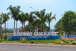
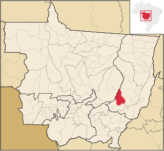
<span class="mw-page-title-main">Carlinda</span> Municipality in Center-West, Brazil

Carlinda is a municipality in the state of Mato Grosso in the Central-West Region of Brazil.

<span class="mw-page-title-main">Santa Rita do Trivelato</span> Municipality in Center-West, Brazil

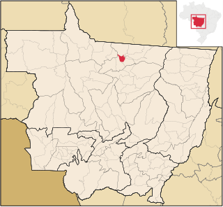
Santa Rita do Trivelato is a municipality in the state of Mato Grosso in the Central-West Region of Brazil.

<span class="mw-page-title-main">Tapurah</span> Municipality in Center-West, Brazil

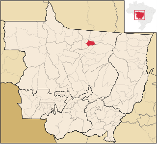
Tapurah is a municipality in the state of Mato Grosso in the Central-West Region of Brazil.

<span class="mw-page-title-main">Colíder</span> Municipality in Center-West, Brazil

Colíder is a municipality in the state of Mato Grosso in the Central-West Region of Brazil. The Colíder Dam is being constructed about 40 km (25 mi) southeast of it on the Teles Pires River.

<span class="mw-page-title-main">Nova Canaã do Norte</span> Municipality in Center-West, Brazil

Nova Canaã do Norte is a municipality in the state of Mato Grosso in the Central-West Region of Brazil.

<span class="mw-page-title-main">Nova Guarita</span> Municipality in Center-West, Brazil

Nova Guarita is a municipality in the state of Mato Grosso in the Central-West Region of Brazil.

<span class="mw-page-title-main">Novo Mundo</span> Municipality in Center-West, Brazil

Novo Mundo is a municipality in the state of Mato Grosso in the Central-West Region of Brazil.

<span class="mw-page-title-main">Terra Nova do Norte</span> Municipality in Center-West, Brazil

Terra Nova do Norte is a municipality in the state of Mato Grosso in the Central-West Region of Brazil.

<span class="mw-page-title-main">Itaúba</span> Municipality in Center-West, Brazil

Itaúba is a municipality in the state of Mato Grosso in the Central-West Region of Brazil.

<span class="mw-page-title-main">Santa Carmem</span> Municipality in Center-West, Brazil

Santa Carmem is a municipality in the state of Mato Grosso in the Central-West Region of Brazil.

<span class="mw-page-title-main">União do Sul</span> Municipality in Center-West, Brazil

União do Sul is a municipality in the state of Mato Grosso in the Central-West Region of Brazil.

<span class="mw-page-title-main">Juscimeira</span> Municipality in Center-West, Brazil

Juscimeira is a municipality in the state of Mato Grosso in the Central-West Region of Brazil.

<span class="mw-page-title-main">São José do Povo</span> Municipality in Center-West, Brazil

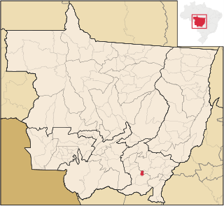
São José do Povo is a municipality in the state of Mato Grosso in the Central-West Region of Brazil.

<span class="mw-page-title-main">Pontal do Araguaia</span> Municipality in Center-West, Brazil

Pontal do Araguaia is a municipality in the state of Mato Grosso in the Central-West Region of Brazil.

<span class="mw-page-title-main">Tesouro</span> Municipality in Center-West, Brazil

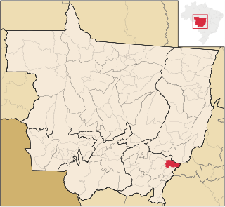
Tesouro is a municipality in the state of Mato Grosso in the Central-West Region of Brazil.

<span class="mw-page-title-main">Vale de São Domingos</span> Municipality in Center-West, Brazil

Vale de São Domingos is a municipality in the state of Mato Grosso in the Central-West Region of Brazil.

<span class="mw-page-title-main">Jauru</span> Municipality in Center-West, Brazil

Jauru is a municipality in the state of Mato Grosso in the Central-West Region of Brazil.

References

  1. IBGE 2020
  2. "Divisão Territorial do Brasil" (in Portuguese). Divisão Territorial do Brasil e Limites Territoriais, Instituto Brasileiro de Geografia e Estatística (IBGE). July 1, 2008. Retrieved December 17, 2009.
  3. "Estimativas da população para 1º de julho de 2009" (PDF) (in Portuguese). Estimativas de População, Instituto Brasileiro de Geografia e Estatística (IBGE). August 14, 2009. Retrieved December 17, 2009.
  4. "Ranking decrescente do IDH-M dos municípios do Brasil" (in Portuguese). Atlas do Desenvolvimento Humano, Programa das Nações Unidas para o Desenvolvimento (PNUD). 2000. Retrieved December 17, 2009.
  5. "Produto Interno Bruto dos Municípios 2002-2005" (PDF) (in Portuguese). Instituto Brasileiro de Geografia e Estatística (IBGE). December 19, 2007. Archived from the original (PDF) on October 2, 2008. Retrieved December 17, 2009.
  6. "Normais Climatológicas Do Brasil 1981–2010" (in Portuguese). Instituto Nacional de Meteorologia. Retrieved 25 May 2024.

12°18′21″S55°19′01″W / 12.3058°S 55.3169°W / -12.3058; -55.3169