Tapurah

Last updated
Tapurah
Municipality
Bandeira de tapurah.jpg
Flag
Tapurah map 2.png
CountryFlag of Brazil.svg  Brazil
Region Center-West
State Mato Grosso
MesoregionNorte Mato-Grossense
Population
 (2020 [1] )
  Total14,046
Time zone UTC -3

Tapurah is a municipality in the state of Mato Grosso in the Central-West Region of Brazil. [2] [3] [4] [5]

See also

Related Research Articles

Santarém Novo Municipality in Northern, Brazil

Santarém Novo is a municipality in the state of Pará in the Northern region of Brazil.

Alto Paraguai Municipality in Center-West, Brazil

Alto Paraguai is a municipality in the state of Mato Grosso in the Mid-West of Brazil.

Arenápolis Municipality in Center-West, Brazil

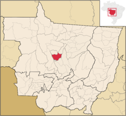
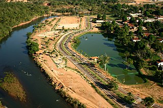
Arenápolis is a municipality in the state of Mato Grosso in the Central-West Region of Brazil. It is the closest town to the South American continental pole of inaccessibility.

Nortelândia Municipality in Center-West, Brazil

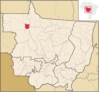
Nortelândia is a municipality in the state of Mato Grosso in the Central-West Region of Brazil.

Nova Marilândia Municipality in Center-West, Brazil

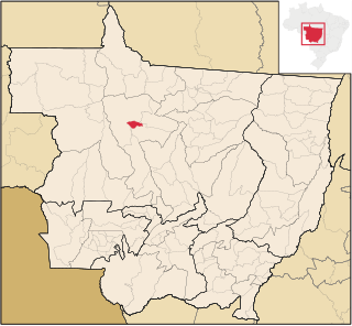
Nova Marilândia is a municipality in the state of Mato Grosso in the Central-West Region of Brazil, it is also the closest inhabitance to South America's Pole of inaccessibility

Acorizal Municipality in Center-West, Brazil

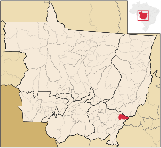
Acorizal is a municipality in the state of Mato Grosso in the Central-West Region of Brazil.

São Félix do Araguaia Municipality in Center-West, Brazil

São Félix do Araguaia is a municipality in the state of Mato Grosso in the Central-West Region of Brazil.

Paranaíta Municipality in Center-West, Brazil

Paranaíta is a municipality in the state of Mato Grosso in the Central-West Region of Brazil.

Ipiranga do Norte is a municipality in the state of Mato Grosso in the Central-West Region of Brazil.

Novo Horizonte do Norte Municipality in Center-West, Brazil

Novo Horizonte do Norte is a municipality in the state of Mato Grosso in the Central-West Region of Brazil.

São José do Rio Claro Municipality in Center-West, Brazil

São José do Rio Claro is a municipality in the state of Mato Grosso in the Central-West Region of Brazil.

Tabaporã Municipality in Center-West, Brazil

Tabaporã is a municipality in the state of Mato Grosso in the Central-West Region of Brazil.

Juruena Municipality in Center-West, Brazil

Juruena is a municipality in the state of Mato Grosso in the Central-West Region of Brazil.

Campos de Júlio Municipality in Center-West, Brazil

Campos de Júlio is a municipality in the state of Mato Grosso in the Central-West Region of Brazil.

Sapezal Municipality in Center-West, Brazil

Sapezal is a municipality in the state of Mato Grosso in the Central-West Region of Brazil.

Santa Carmem Municipality in Center-West, Brazil

Santa Carmem is a municipality in the state of Mato Grosso in the Central-West Region of Brazil.

União do Sul Municipality in Center-West, Brazil

União do Sul is a municipality in the state of Mato Grosso in the Central-West Region of Brazil.

Pontal do Araguaia Municipality in Center-West, Brazil

Pontal do Araguaia is a municipality in the state of Mato Grosso in the Central-West Region of Brazil.

Torixoréu Municipality in Center-West, Brazil

Torixoréu is a municipality in the state of Mato Grosso in the Central-West Region of Brazil.

Vale de São Domingos Municipality in Center-West, Brazil

Vale de São Domingos is a municipality in the state of Mato Grosso in the Central-West Region of Brazil.

References

  1. IBGE 2020
  2. "Divisão Territorial do Brasil" (in Portuguese). Divisão Territorial do Brasil e Limites Territoriais, Instituto Brasileiro de Geografia e Estatística (IBGE). July 1, 2008. Retrieved December 17, 2009.
  3. "Estimativas da população para 1º de julho de 2009" (PDF) (in Portuguese). Estimativas de População, Instituto Brasileiro de Geografia e Estatística (IBGE). August 14, 2009. Retrieved December 17, 2009.
  4. "Ranking decrescente do IDH-M dos municípios do Brasil" (in Portuguese). Atlas do Desenvolvimento Humano, Programa das Nações Unidas para o Desenvolvimento (PNUD). 2000. Retrieved December 17, 2009.
  5. "Produto Interno Bruto dos Municípios 2002-2005" (PDF) (in Portuguese). Instituto Brasileiro de Geografia e Estatística (IBGE). December 19, 2007. Retrieved December 17, 2009.

Coordinates: 12°46′19″S56°33′14″W / 12.7719°S 56.5539°W / -12.7719; -56.5539