Colniza

Last updated
Colniza
Municipality
The Municipality of Colniza
Brasao do municipio de Colniza MT.png
MatoGrosso Municip Colniza.svg
Location of Colniza
Coordinates: 09°32′38″S57°26′56″W / 9.54389°S 57.44889°W / -9.54389; -57.44889 Coordinates: 09°32′38″S57°26′56″W / 9.54389°S 57.44889°W / -9.54389; -57.44889
Country Flag of Brazil.svg  Brazil
Region Central-West
State Bandeira de Mato Grosso.svg Mato Grosso
FoundedNovember 26, 1998
Government
   Mayor Sergio Bastos Dos Santos (PMBD)
Area
  Total27.947.646 km2 (10.790 sq mi)
Elevation
0 m (0 ft)
Population
 (2020 [1] )
  Total39,861
  Density0.5/km2 (1/sq mi)
Time zone UTC−3 (BRT)

Colniza is a municipality in the state of Mato Grosso, Brazil.

Contents

Demographics

Colniza has the highest homicide rate in Brazil with 165 deaths per year per 100 thousand inhabitants. [2] [3] It is the westernmost and largest (by area) municipality of the state.

Conservation

The municipality of Colniza has a mosaic of conservation units consisting of the Rio Madeirinha Ecological Station, the Rio Roosevelt Ecological Station, the Tucumã State Park and the Guariba-Roosevelt Extractive Reserve.

Satellite monitoring showed that Colniza had the highest level of deforestation in Mato Grosso in the six years from 2010 to 2016, with 78,556 hectares (194,120 acres) cleared, most of it illegally. Rates of deforestation rose successively in 2013, 2014 and 2015. [4]

The 13,683 hectares (33,810 acres) Rio Madeirinha Ecological Station is a fully protected environmental unit created in 1997. [5] The 96,925 hectares (239,510 acres) Rio Roosevelt Ecological Station is a strictly protected conservation unit created in 1997. [6] The 164,224 hectares (405,810 acres) Guariba-Roosevelt Extractive Reserve is a sustainable use unit created in 1996. [7] The municipality also contains 3,641 hectares (9,000 acres) of the Campos Amazônicos National Park, a 961,318 hectares (2,375,470 acres) protected area created in 2006 that protects an unusual enclave of cerrado vegetation in the Amazon rainforest. [8] It contains 44% of the 227,817 hectares (562,950 acres) Igarapés do Juruena State Park, created in 2002. [9]

Related Research Articles

Roosevelt River River in Brazil

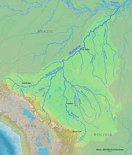
The Roosevelt River is a Brazilian river, a tributary of the Aripuanã River about 760 km (470 mi) in length.

Apuí Municipality in North, Brazil

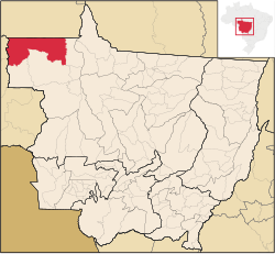
Apuí is a municipality located in the Brazilian state of Amazonas. Its population was 22,359 (2020) and its area is 54,240 km2.

Novo Aripuanã Municipality in North, Brazil

Novo Aripuanã is a municipality located in the Brazilian state of Amazonas.

Machadinho dOeste Place in Rondonia, Brazil

Machadinho d'Oeste is a municipality located in the Brazilian state of Rondônia. Its population was 40,867 (2020) and its area is 8,509 km².

Aripuanã Municipality in Center-West, Brazil

Aripuanã is a municipality in the state of Mato Grosso in the Central-West Region of Brazil. It is located on the banks of the Aripuanã River.

Madeirinha River River in Brazil

Madeirinha River is a river of Mato Grosso and Amazonas states in north-western Brazil, a left tributary of the Roosevelt River.

Guariba River (Aripuanã River tributary)

Guariba River is a river of the Mato Grosso and Amazonas states in north-western Brazil. It is a tributary of the Aripuanã River.

Juruena National Park

Juruena National Park, declared in 2006, is the third largest national park of Brazil. It is located along the Juruena River, in the north of Mato Grosso state and the south of Amazonas state. It forms part of a corridor of protected areas that is meant to contain agricultural expansion into the Amazon rainforest.

Rio Roosevelt Ecological Station

The Rio Roosevelt Ecological Station is an ecological station in the state of Mato Grosso, Brazil.

Itaituba I National Forest

Itaituba I National Forest is a national forest in the state of Pará, Brazil.

Mapinguari National Park National Park in Brazil

Mapinguari National Park is a national park in the states of Rondônia and Amazonas, Brazil. It covers a large area of Amazon rainforest. The boundaries have been adjusted several times.

Campos Amazônicos National Park

The Campos Amazônicos National Park is a National park in the states of Rondônia, Amazonas and Mato Grosso, Brazil.

Guariba-Roosevelt Extractive Reserve

The Guariba-Roosevelt Extractive Reserve is an extractive reserve in the state of Mato Grosso, Brazil. A small traditional population live through fishing, hunting, small-scale agriculture and sale of forest products such as nuts. The reserve is under intense pressure from illegal logging and land grabbing.

Manicoré State Forest

The Manicoré State Forest is a state forest in the state of Amazonas, Brazil.

Apuí Mosaic

The Apuí Mosaic is a protected area mosaic in the state of Amazonas, Brazil.

Southern Amazon Mosaic

The Southern Amazon Mosaic is a protected area mosaic in Brazil.

Rio da Casca Ecological Station

The Rio da Casca Ecological Station is an ecological station in the state of Mato Grosso, Brazil. It protects a partly deforested area of savanna.

Guariba Extractive Reserve

The Guariba Extractive Reserve is an extractive reserve in the state of Amazonas, Brazil.

Bararati Sustainable Development Reserve

The Bararati Sustainable Development Reserve' is a sustainable development reserve in the state of Amazonas, Brazil.

Mujica Nava Ecological Station

The Mujica Nava Ecological Station (Portuguese: Estação Ecológica Antônio Mujica Nava is an ecological station in the state of Rondônia, Brazil. In 2010 it was incorporated into the Mapinguari National Park, but this decision was later challenged.

References

  1. IBGE 2020
  2. Tom Phillips 2008.
  3. Lisandra Paraguassú 2007.
  4. Câmara Setorial mantém área da Resex ...
  5. ESEC do Rio Madeirinha – ISA.
  6. ESEC do Rio Roosevelt – ISA.
  7. RESEX Guariba-Roosevelt – ISA.
  8. PARNA dos Campos Amazônicos – ISA.
  9. PES Igarapés do Juruena – ISA.

Sources