Jauru

Last updated
Jauru MT
Municipality
Flag of Jauru.jpg
MatoGrosso Municip Jauru.svg
CountryFlag of Brazil.svg  Brazil
Region Center-West
State Mato Grosso
MesoregionSudoeste Mato-Grossense
Area
  Total0.470072 sq mi (1.217480 km2)
Population
 (2020 [1] )
  Total8,582
  Density20.8/sq mi (8.03/km2)
Time zone UTC−3 (BRT)

Jauru is a municipality in the state of Mato Grosso in the Central-West Region of Brazil. [2] [3] [4] [5]

See also

Related Research Articles

Nova Marilândia Municipality in Center-West, Brazil

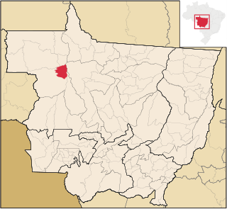
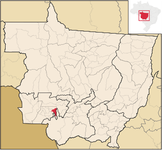
Nova Marilândia is a municipality in the state of Mato Grosso in the Central-West Region of Brazil, it is also the closest inhabitance to South America's Pole of inaccessibility

Porto Alegre do Norte Municipality in Center-West, Brazil

Porto Alegre do Norte is a municipality in the state of Mato Grosso in the Central-West Region of Brazil.

Nova Monte Verde Municipality in Center-West, Brazil

Nova Monte Verde is a municipality in the state of Mato Grosso in the Central-West Region of Brazil.

Brasnorte Municipality in Center-West, Brazil

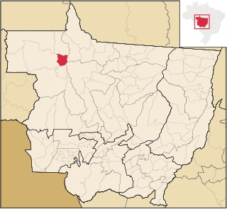
Brasnorte is a municipality in the state of Mato Grosso in the Central-West Region of Brazil.

Castanheira, Mato Grosso Municipality in Center-West, Brazil

Castanheira, Mato Grosso is a municipality in the state of Mato Grosso in the Central-West Region of Brazil.

Juruena Municipality in Center-West, Brazil

Juruena is a municipality in the state of Mato Grosso in the Central-West Region of Brazil.

Matupá Municipality in Center-West, Brazil

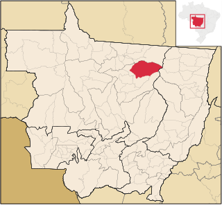
Matupá is a municipality in the state of Mato Grosso in the Central-West Region of Brazil.

Sapezal Municipality in Center-West, Brazil

Sapezal is a municipality in the state of Mato Grosso in the Central-West Region of Brazil.

Marcelândia Municipality in Center-West, Brazil

Marcelândia is a municipality in the state of Mato Grosso in the Central-West Region of Brazil.

União do Sul Municipality in Center-West, Brazil

União do Sul is a municipality in the state of Mato Grosso in the Central-West Region of Brazil.

Araputanga Municipality in Center-West, Brazil

Araputanga is a municipality in the state of Mato Grosso in the Central-West Region of Brazil.

Figueirópolis dOeste Municipality in Center-West, Brazil

Figueirópolis d'Oeste is a municipality in the state of Mato Grosso in the Central-West Region of Brazil.

Glória dOeste Municipality in Center-West, Brazil

Glória d'Oeste is a municipality in the state of Mato Grosso in the Central-West Region of Brazil.

Indiavaí Municipality in Center-West, Brazil

Indiavaí is a municipality in the state of Mato Grosso in the Central-West Region of Brazil.

Lambari dOeste Municipality in Center-West, Brazil

Lambari d'Oeste is a municipality in the state of Mato Grosso in the Central-West Region of Brazil.

Mirassol dOeste Municipality in Center-West, Brazil

Mirassol d'Oeste is a municipality in the state of Mato Grosso in the Central-West Region of Brazil.

Reserva do Cabaçal Municipality in Southeast, Brazil

Reserva do Cabaçal is a municipality in the state of Mato Grosso in the Central-West Region of Brazil.

Rio Branco, Mato Grosso Municipality in Southeast, Brazil

Rio Branco is a municipality in the state of Mato Grosso in the Central-West Region of Brazil.

Salto do Céu Municipality in Southeast, Brazil

Salto do Céu is a municipality in the state of Mato Grosso in the Central-West Region of Brazil.

São José dos Quatro Marcos Municipality in Southeast, Brazil

São José dos Quatro Marcos is a municipality in the state of Mato Grosso in the Central-West Region of Brazil.

References

  1. IBGE 2020
  2. "Divisão Territorial do Brasil" (in Portuguese). Divisão Territorial do Brasil e Limites Territoriais, Instituto Brasileiro de Geografia e Estatística (IBGE). July 1, 2008. Retrieved December 17, 2009.
  3. "Estimativas da população para 1º de julho de 2009" (PDF) (in Portuguese). Estimativas de População, Instituto Brasileiro de Geografia e Estatística (IBGE). August 14, 2009. Retrieved December 17, 2009.
  4. "Ranking decrescente do IDH-M dos municípios do Brasil" (in Portuguese). Atlas do Desenvolvimento Humano, Programa das Nações Unidas para o Desenvolvimento (PNUD). 2000. Archived from the original on October 3, 2009. Retrieved December 17, 2009.
  5. "Produto Interno Bruto dos Municípios 2002-2005" (PDF) (in Portuguese). Instituto Brasileiro de Geografia e Estatística (IBGE). December 19, 2007. Archived from the original (PDF) on October 2, 2008. Retrieved December 17, 2009.

Coordinates: 15°20′31″S58°51′57″W / 15.3419°S 58.8658°W / -15.3419; -58.8658