
Saint Lucia is a constitutional monarchy and an island country of the West Indies in the eastern Caribbean. The island was previously called Iouanalao and later Hewanorra, names given by the native Arawaks and Caribs (respectively), two Amerindian peoples. Part of the Windward Islands of the Lesser Antilles, it is located north/northeast of the island of Saint Vincent, northwest of Barbados and south of Martinique. It covers a land area of 617 km2 with an estimated population of over 180,000 people as of 2018. The nation's capital and largest city is Castries.

Saint Lucia was inhabited by the Arawak and Kalinago Caribs before European contact in the early 16th century. It was colonized by the British and French in the 17th century and was the subject of several possession changes until 1814, when it was ceded to the British by France for the final time. In 1958, St. Lucia joined the short-lived semi-autonomous West Indies Federation. Saint Lucia was an associated state of the United Kingdom from 1967 to 1979 and then gained full independence on February 22, 1979.
Transport in Saint Lucia includes transportation to and from Saint Lucia, which is a sovereign island country located in the eastern Caribbean Sea. It also includes transportation from one part of the island to another.

Castries is the capital and largest city of Saint Lucia, an island country in the Caribbean. The urban area has a population of approximately 20,000, while the eponymous district has a population of 70,000, as at May 2013. The city covers 80 km2 (31 sq mi).

Hewanorra International Airport, located near Vieux Fort Quarter, Saint Lucia, in the Caribbean, is the larger of Saint Lucia's two airports and is managed by the Saint Lucia Air and Seaports Authority (SLASPA). It is on the southern cape of the island, about 53.4 km (33.2 mi) from the capital city, Castries.

Gros Islet District, one of 10 first order subdivision of the Caribbean island nation of Saint Lucia which includes the island's northernmost point, Cap Point and the notable Cap Estate, where the renowned St. Lucia Golf and Country Club is located. Whilst the town of Gros Islet is an important administrative centre, Rodney Bay is the main financial center of the district.
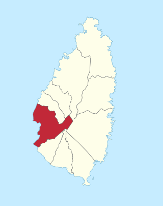
Soufrière is a district on the Southwest coast of Saint Lucia in the West Indies. Soufrière was the former capital of Saint Lucia during times of French rule. It is now a small fishing port with an emerging tourism industry. It has several tourist sites, including a "drive-in" volcano, the Diamond Botanical Gardens with waterfall and historic mineral baths, plus the nearby beaches of Anse Chastanet to the north and Malgretout to the south.

Dennery District is one of 10 districts of the Caribbean island nation of Saint Lucia. The seat of Dennery District is the Dennery Village. The main economic activities are fishing, and the cultivation of lima beans, bananas, and other tropical fruit. The population of the quarter was estimated at 12,876 in 2002 and fell to 12,767 in 2010.

The island nation of Saint Lucia is divided into 10 districts. The name Quarters or Quartiers originally came from the French period in Saint Lucia. The 2001 and 2010 Census of Saint Lucia refers to the first level administrative divisions as districts. The FIPS and ISO standards regularly called these divisions quarters or quartiers in French. The former district of Dauphin Quarter was merged into Gros Islet District and the former district of Praslin Quarter was merged into Micoud District.

Choiseul District is one of the 10 districts of the Caribbean island nation of Saint Lucia. Located on the southwestern side of the island, the district is home to 6,130 people, according to the 2019 census. The seat of Choiseul District is the town of Choiseul.
Bank of Saint Lucia is a subsidiary of Eastern Caribbean Financial Holding Company. It was formed in July 2001 as a result of the merger between National Commercial Bank and the Saint Lucia Development Bank.

The Metropolitan Archdiocese of Castries is an archdiocese of the Latin Church of the Catholic Church in the Caribbean. The archdiocese consists of the entirety of the former British dependency of Saint Lucia and is a metropolitan see, the suffragans of the Castries Province being the Dioceses of Roseau, Saint George's in Grenada, St. John's-Basseterre and Kingstown. The archdiocese is a member of the Antilles Episcopal Conference.

The George Odlum Stadium is a 9,000 capacity football stadium in Vieux Fort, Saint Lucia.

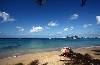
Saint Lucia, an island nation in the Caribbean islands, has a relatively large tourism industry. Due to the relatively small land area of the country, most of the governmental promotion is performed by the state-operated Saint Lucia Tourism Authority, led by Executive Chairperson Agnes.
Rodney Bay is a town and bay located in the Gros Islet District on the island of Saint Lucia. Gros Islet is one of the ten districts in the island. It can be found on the northwestern coast of the island above the Castries District, where the capital of St. Lucia is, and the former Dauphin quarter. St. Lucia is a small island in North America located in the Caribbean Sea and it is the largest of the Caribbean's Windward Islands. The Windward islands include Martinique, Saint Vincent and the Grenadines, Barbados, Trinidad and Tobago and Grenada. It is in a chain of islands in the Lesser Antilles with Martinique to the north and Saint Vincent and the Grenadines to the south. These islands are southeast of the islands of Puerto Rico and Haiti. Out of the two airports in St.Lucia, Hewanorra and Charles airport, Rodney Bay is closer to the latter.
La Tourney is a town in Vieux Fort District in the island country of Saint Lucia. La Tourney is in the La Tourney/Cedar Heights section of Vieux Fort District, which has a population of 706. La Tourney is located on the southern coast of Saint Lucia, close to Hewanorra International Airport. There is also a 127 m (417 ft) high Tourney Mountain nearby at 13°44′34″N60°57′55″W.
Beane Air Force Base was a United States Air Force base located near Vieux Fort, Saint Lucia, in the Caribbean Sea. It is now the site of Hewanorra International Airport.
Santa Lucia Airport refers to Felipe Ángeles International Airport, an air force base and site of the new airport for Mexico City after cancellation of the Texcoco airport project, Tecámac, State of Mexico, or it may refer to:

Vieux Fort is a town located near the southernmost point of Saint Lucia, a Caribbean island nation. It is named after a fort that used to watch out towards Saint Vincent towards the south. The population of the town was 4,574 in 2000 while the surrounding district of Vieux Fort has a total population of about 15,132 in 2010.


