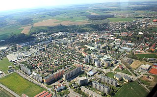
Historically Vimperk has been known as an important regional trade centre, being located on the Golden Trail from Passau to Prachatice. Vimperk is also renowned for its glass-making and printing traditions.
Administrative division
Vimperk consists of 22 municipal parts (in brackets population according to the 2021 census):[2]
Vimperk I (504)
Vimperk II (5,460)
Vimperk III (375)
Arnoštka (6)
Bořanovice (72)
Boubská (101)
Cejsice (18)
Hrabice (124)
Klášterec (32)
Korkusova Huť (35)
Křesanov (37)
Lipka (83)
Michlova Huť (12)
Modlenice (3)
Pravětín (85)
Skláře (23)
Solná Lhota (14)
Sudslavice (35)
U Sloupů (84)
Veselka (8)
Vnarovy (14)
Výškovice (60)
Geography
Vimperk is located about 17 kilometres (11mi) south of Prachatice and 50km (31mi) west of České Budějovice. The southern half of the municipal territory lies the Bohemian Forest and is protected as the Šumava Protected Landscape Area; the northern part lies in the Bohemian Forest Foothills. The highest point is the Šerava mountain at 1,061m (3,481ft) above sea level. Other high mountains include Kamenná hora at 1,057m (3,468ft) and Kupa at 1,044m (3,425ft). The town is situated in the Volyňka River valley.
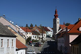
Svobody Square with Church of the Visitation of the Virgin Mary
The whole area was covered by deep forest until the middle of the 13th century, when the Vimperk Castle was founded.[4] The castle was most likely founded by King Ottokar II to protect the border and the new branch of the Golden Trail, the important trade route from Passau to Bohemia. In the 1260s, Ottokar II lent the manor and the castle, which included the walled fortress with a tower house and a palace, to the noble family of Janovic. In 1370, the properties of Janovic family forfeited to the royal crown.[5]
From the end of the 14th century, the Vimperk estate was a property of the Kaplíř of Sulevice noble family. During their rule, the settlement and the castle were merged into a single fortified unit and an outpost, mighty round tower Haselburg, was built.[5] Despite the era of the Hussite Wars, Vimperk prospered, and in 1479, it was granted the town rights by King Vladislaus II. After it was owned by the Malovec of Chýnov family for a short period, Vimperk was acquired by the Rosenberg family in the 16th century. During their rule, the trade on the Golden Trail reached its peak.[4] Probably during the 16th century the castle began to be rebuilt into the Renaissance residence.[5]
During the war in 1547 led by Czech Protestants against the King Ferdinand I, the citizens of Vimperk sided with the Czech Protestants. After Ferdinand's eventual triumph he gained Vimperk among his spoils. in 1553 he sold Vimperk to Jáchym of Hradec, but it was seized by William of Rosenberg. William's brother Peter Vok of Rosenberg (the last member of the Rosenberg family) sold the town in 1601 to Volf Novohradský of Kolowrat, who sided with the Czech Protestants during the rebellion of 1618.
Between 1622 and 1624, Jáchym Novohradský of Kolowrat built new castle buildings over portions of the castle that had been destroyed. This construction and other expensive activities ruined him financially so that he was forced in to sell the castle in 1630 to Oldřich, Count of Eggenberg. The Eggenberg family owned Vimperk Castle until 1719, when the House of Eggenberg died out and all of the Eggenberg holdings, including the Český Krumlov estate, fell to the Schwarzenberg family.[5]
In 1857, the town suffered yet another fire which caused extensive damage to many of the buildings on the main town square and to the castle. A fundraising was announced, to which Emperor Franz Joseph I also contributed, and within a year all the houses were repaired.[6]
In 1938, Vimperk was annexed by Nazi Germany and administered as part of the Reichsgau Sudetenland. All non-Germanic people were expelled. At the end of World War II, all German people were expelled from Vimperk. In 1945, American Allied Forces liberated Vimperk, which is commemorated by a plaque in the centre of the town.
In the 19th century, Vimperk became an industrial centre of the Bohemian Forest region. The industrial character of the town remained in the years 1945–1989. After 1989, the industry began to decline and many businesses closed. The town began to focus more on tourism.[4]
The largest employer based in the town is a branch of the Rohde & Schwarz company, which is a manufacturer of electrical devices. It has more than 900 employees and belongs to the largest employers in the entire region.[10]
Transport
The I/4 road, which connects Strakonice with the Czech-German border, passes through the town.
Vimperk is located on the railway line Strakonice–Volary.
Sights
Vimperk Castle
The Vimperk Castle is the main landmark of the town. The Schwarzenberg family was the last private proprietor of the castle. In 1947, the Vimperk Castle was nationalized by the Czechoslovak state. Since 2015, it has been owned by the National Heritage Institute. A part of the property serves as a museum, and the headquarters of the Šumava National Park and Šumava Protected Landscape Area are also located there.[5]
There are three churches in Vimperk: Church of Saint Bartholomew, Church of the Visitation of the Virgin Mary, and Church of the Most Sacred Heart of Jesus. Church of Saint Bartholomew is oldest sacral building in the town. It was built in the second half of the 13th century in its today's form is in the pseudo-Gothic style.[11] The Church of the Visitation of the Virgin Mary is located on the town square and since its construction it has been the spiritual centre of Vimperk. It was built in the 14th century, before 1365.[12]
Prachatice is a town in the South Bohemian Region of the Czech Republic. It has about 11,000 inhabitants. The historic town centre is well preserved and is protected by law as an urban monument reservation.
Czech nobility consists of the noble families from historical Czech lands, especially in their narrow sense, i.e. nobility of Bohemia proper, Moravia and Austrian Silesia – whether these families originated from those countries or moved into them through the centuries. These are connected with the history of Great Moravia, Duchy of Bohemia, later Kingdom of Bohemia, Margraviate of Moravia, the Duchies of Silesia and the Crown of Bohemia, the constitutional predecessor state of the modern-day Czech Republic.
Třeboň is a spa town in Jindřichův Hradec District in the South Bohemian Region of the Czech Republic. It has about 8,300 inhabitants. The historic town centre with the castle complex is well preserved and is protected by law as an urban monument reservation.
Strakonice is a town in the South Bohemian Region of the Czech Republic. It has about 23,000 inhabitants.
Rychnov nad Kněžnou is a town in the Hradec Králové Region of the Czech Republic. It has about 11,000 inhabitants. The historic town centre is well preserved and is protected by law as an urban monument zone.
Husinec is a town in Prachatice District in the South Bohemian Region of the Czech Republic. It has about 1,400 inhabitants. It is known as the birthplace of one of the main figures in Czech history, Jan Hus. The historic town centre is well preserved and is protected by law as an urban monument zone.
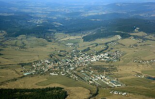
Volary is a town in Prachatice District in the South Bohemian Region of the Czech Republic. It has about 3,700 inhabitants. It is located in the Bohemian Forest, close to the border with Germany. An area in the northern part of the town with timber-framed Alpine-type buildings is well preserved and is protected by law as a village monument reservation.
Netolice is a town in Prachatice District in the South Bohemian Region of the Czech Republic. It has about 2,500 inhabitants. The historic town centre is well preserved and is protected by law as an urban monument zone.
Prachatice District is a district in the South Bohemian Region of the Czech Republic. Its capital is the town of Prachatice.
Bavorov is a town in Strakonice District in the South Bohemian Region of the Czech Republic. It has about 1,600 inhabitants. The historic town centre is well preserved and is protected by law as an urban monument zone.
Soběslav is a town in Tábor District in the South Bohemian Region of the Czech Republic. It has about 7,100 inhabitants. The historic town centre is well preserved and is protected by law as an urban monument zone.
Sedlice is a town in Strakonice District in the South Bohemian Region of the Czech Republic. It has about 1,300 inhabitants. The historic town centre is well preserved and is protected by law as an urban monument zone.
Přídolí is a market town in Český Krumlov District in the South Bohemian Region of the Czech Republic. It has about 700 inhabitants.
Strážný is a market town in Prachatice District in the South Bohemian Region of the Czech Republic. It has about 400 inhabitants.
Mšec is a market town in Rakovník District in the Central Bohemian Region of the Czech Republic. It has about 900 inhabitants.
Český Krumlov is a town in the South Bohemian Region of the Czech Republic. It has about 13,000 inhabitants. It is known as a tourist centre, which is among the most visited places in the country. The historic centre with the Český Krumlov Castle complex is protected by law as an urban monument reservation, and since 1992, it has been a designated UNESCO World Heritage Site because of its well-preserved Gothic, Renaissance and Baroque architecture.
Dešenice is a market town in Klatovy District in the Plzeň Region of the Czech Republic. It has about 700 inhabitants.
Čkyně is a municipality and village in Prachatice District in the South Bohemian Region of the Czech Republic. It has about 1,600 inhabitants.
Lhenice is a market town in Prachatice District in the South Bohemian Region of the Czech Republic. It has about 2,100 inhabitants.
Stachy is a municipality and village in Prachatice District in the South Bohemian Region of the Czech Republic. It has about 1,100 inhabitants. The historic part of the village is protected by law as a village monument reservation. The local part of Chalupy is protected as a village monument zone.
↑ Mommsen, Hans; Kováč, Dušan; Malíř, Jiří (2001). "Im Widerstreit der Selbstbestimmungsansprüche: vom Habsburgerstaat zur Tschechoslowakei–die Deutschen der böhmischen Länder 1918 bis 1919". Der Erste Weltkrieg und die Beziehungen zwischen Tschechen, Slowaken und Deutschen (in German). Klartext. p.201. ISBN3-88474-951-X.
This page is based on this Wikipedia article Text is available under the CC BY-SA 4.0 license; additional terms may apply. Images, videos and audio are available under their respective licenses.