St Helier is one of the twelve parishes of Jersey, the largest of the Channel Islands in the English Channel. St Helier has a population of 35,822 – over one-third of the total population of Jersey – and is the capital of the island.

St Clement is one of the twelve parishes of Jersey in the Channel Islands. Its parish hall is around 3.6 kilometres (2.2 mi) south-east of St Helier. The parish has a population of 9,221 and is the second most densely populated.

Grouville is one of the twelve parishes of Jersey in the Channel Islands. The parish is around 3.9 kilometres (2.4 mi) east of St Helier. The parish covers a surface area of 4,354 vergées (7.8 km²). The parish includes the south-east portion of the main island of the Bailiwick of Jersey, as well as the Minquiers islets several miles to the south, and is dominated by the broad sweep of the Royal Bay of Grouville. It borders St. Clement, St. Saviour and St. Martin.

St Martin is one of the twelve parishes of Jersey in the Channel Islands. It is 5.5 kilometres (3.4 mi) north-east of St Helier. It has a population of 3,763. The parish covers 10.3 km2 (4.0 sq mi).

Trinity is one of the twelve parishes of Jersey in the Channel Islands. It is 5.8 kilometres (3.6 mi) north of St Helier. It has a population of 3,156. The parish covers 6,975 vergées. Les Platons in the north of the parish is the highest point in Jersey. The parish borders St John, St Helier, St Saviour and St Martin.

St John is one of the twelve parishes of Jersey and is around 7.3 kilometres (4.5 mi) north of St Helier on the north coast of the island. It has a surface area of 8.7 km2. St John's Village is also the name of the main village in the parish.
St Ouen is one of the twelve parishes of Jersey in the Channel Islands. It is around 8.8 kilometres (5.5 mi) north-west of St Helier. It has a population of 4,097. The parish is the largest parish by surface area, covering 8,525 vergées (15 km2), and is located in part on a peninsula.

St Lawrence is one of the twelve parishes of Jersey in the Channel Islands. It is located 8.0 kilometres (5.0 mi) west of St Helier. The parish covers 5,258 vergées (9.5 km2) and occupies the centre of the Island. St Lawrence Village is also the name of a village in the parish.
A vingtaine is a political subdivision of Jersey. They are subdivisions of the various parishes of Jersey, and one, La Vingtaine de la Ville, in Saint Helier is further divided into two cantons.

The Vingtaine de la Ville is one of the six vingtaines of Saint Helier in Jersey, and roughly corresponds to the historic town centre and harbours. It is divided into two cantons:
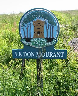
The National Trust for Jersey is a charitable organisation which aims at preserving and safeguarding sites of historic, aesthetic and natural interest in Jersey.

Vingtaine de la Moye is one of the four vingtaines of the Parish of St. Brélade in Jersey in the Channel Islands.
La Grande Vingtaine is one of the three vingtaines of St. Clement in the Channel Island of Jersey. It lies to the east of La Vingtaine du Rocquier, and spans the area between Le Hocq and the parish's border with Grouville.

Vingtaine du Rocquier is one of the three vingtaines of the Parish of Saint Clement in Jersey. Rotchi means rock or rocky place in Jèrriais, and the vingtaine covers generally low-lying coastal terrain stretching north from Le Hocq and rising up hillsides. Within the vingtaine are Saint Clement's school (primary) and Le Rocquier School.

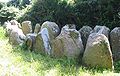
The dolmens of Jersey are neolithic sites, including dolmens, in Jersey. They range over a wide period, from around 4800 BC to 2250 BC, these dates covering the periods roughly designated as Neolithic, or “new stone age”, to Chalcolithic, or “copper age”.
La Vingtaine du Nord is one of the three vingtaines of the Parish of St John in Jersey, Channel Islands. It contains the second highest point in Jersey at Mont Mado (473 ft).

La Motte is a tidal island, and listed archaeological site, also known as Green Island, located in the Vingtaine de Samarès in the parish of St Clement on the south-east coast of Jersey, Channel Islands.

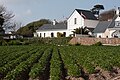
Samarès Manor is a manor house with medieval origins in the Vingtaine de Samarès, in the parish of St. Clement in Jersey, and is the traditional home of the Seigneur de Samarès. The name Samarès is an old French word meaning salt-marsh, and much of the low-lying surrounding areas are or were coastal marshes.

Archaeology is promoted in Jersey by the Société Jersiaise and by Jersey Heritage. Promotion in the Bailiwick of Guernsey being undertaken by La Société Guernesiaise, Guernsey Museums, the Alderney Society with World War II work also undertaken by Festung Guernsey.
This page is based on this
Wikipedia article Text is available under the
CC BY-SA 4.0 license; additional terms may apply.
Images, videos and audio are available under their respective licenses.