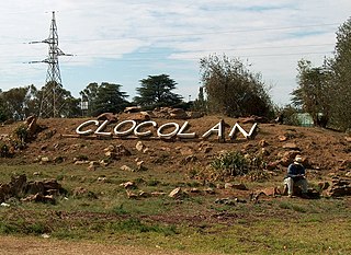
Clocolan, officially renamed Hlohlolwane, was established in 1906, is a small town in the Free State Province of South Africa. The Basotho called the place Hlohlolwane. New inhabitants mispronounced the name and called it Clocolan.

Standerton is a large commercial and agricultural town lying on the banks of the Vaal River in Mpumalanga, South Africa, which specialises in cattle, dairy, maize and poultry farming. The town was established in 1876 and named after Boer leader Commandant A. H. Stander. During the First Boer War a British garrison in the town was besieged by the Boers for three months. General Jan Smuts won this seat during elections and went on to assist in setting up the League of Nations. Standerton is part of the Lekwa Local Municipality.
White River is a small holiday and farming town situated just north of Mbombela in Mpumalanga, South Africa. The farms in the region produce tropical fruits, macadamia nuts, vegetables, flowers and timber. As of 2011, White River had a population of 16,639.
Alldays is a small town in the Limpopo province of South Africa that serves a large area of private game and hunting farms. It has a population of 2,987.

Britstown is a small farming town situated in the Northern Cape province of South Africa, in the Pixley ka Seme District Municipality, Emthanjeni Local Municipality. The town is named after Hans Brits who settled here after he accompanied David Livingstone on a venture into the interior.
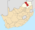
Blouberg Municipality is a local municipality within the Capricorn District Municipality, in the Limpopo province of South Africa, bordering Botswana. It takes its name from the Blouberg, a mountain range located to the west of the western end of the Soutpansberg mountain range, north west of the town of Vivo. Blouberg is home to some of the most spectacular rock climbing in South Africa. The rock climbing destination is famous for its big wall natural climbing with route lengths up to 350m. The vegetation ranges from sub-tropical savanna at the base, to alpine near the summit.

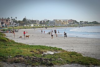
Bloubergstrand is a seaside suburb of the City of Cape Town, South Africa, along the shores of Table Bay, 15 kilometres (9.3 mi) due north of the city centre of Cape Town. The name Bloubergstrand literally means "blue mountain beach" in Afrikaans, and is derived from Blaauwberg, a nearby hill. Bloubergstrand is mainly a residential area, and attracts large numbers of visitors especially kitesurf enthusiasts. The beach at Bloubergstrand is a popular location for a classic view of Table Mountain across the bay and is one of the world's top kitesurf destinations. Robben Island is located 6.9 kilometres (4.3 mi) west of the coast of Bloubergstrand.

Alexandria is a small farming town in the Eastern Cape of South Africa and is situated 100 km North East of Gqeberha, Eastern Cape, on the way to Bushman's River Mouth, Kenton-on-Sea and Port Alfred. Alexandria is part of the Ndlambe Local Municipality in the Sarah Baartman District Municipality of the Eastern Cape.
Melkbosstrand is a coastal town located on the South West Coast of South Africa, 30 km north of Cape Town. It forms part of the City of Cape Town Metropolitan Municipality, the municipality governing Cape Town and its greater metropolitan area.

Table View is a West Coast suburb of Cape Town, South Africa, named after its view of Table Mountain. It has expanded rapidly since the 1970s and has extensions such as Flamingo Vlei, Sunridge, West Riding, Parklands, and Killarney. Table View has various shopping malls, such as Bayside Mall and Table Bay Mall.
Kerugoya is the biggest town in Kirinyaga County, located 10 kilometres east of Karatina and 40 kilometres west of Embu. It is situated in the former Kirinyaga district. Travel directions by road from Nairobi, is through Thika road past Thika, Kenol and Makuyu. The road leads through Makutano until Sagana town, where a road branches off the East towards Kagio town up to Kirinyaga University branching North towards the town.
Dihlabeng Municipality is a local municipality within the Thabo Mofutsanyane District Municipality, in the Free State province of South Africa. It was established after the first general local government elections on 5 December 2000, which heralded the final phase of local government reform as envisaged in 1994 at the onset of the process of democratisation and the end of apartheid. The seat is Bethlehem.
Modderfontein is a small town on the East Rand of Gauteng, South Africa. It began as a mining town adjacent to the Mud River, hence its name which is Afrikaans for "mud spring" or "fountain". It is located in the City of Johannesburg Metropolitan Municipality, adjacent to Kempton Park in the neighbouring City of Ekurhuleni Metropolitan Municipality.
Impendle is a town in Umgungundlovu District Municipality in the KwaZulu-Natal province of South Africa.
Senwabarwana, also known as Bochum, is a town in the Blouberg Local Municipality of the Capricorn District Municipality in the Limpopo province of South Africa. The town is the seat of the Blouberg Local Municipality. It is located about 93 km northwest of the city Polokwane.
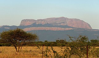
The Blouberg, meaning "Blue Mountain" in Dutch, is a range of mountains in the Limpopo Province, at the far north of South Africa. It is located in Blouberg Local Municipality, Capricorn District. The mountain is entrenched in the history of the local Northern Sotho people, and they have different names for its various parts.
Indermark is a village in the Capricorn District Municipality in the Limpopo province of South Africa. The village is situated in the Blouberg Local Municipality.
Ga-Sebotse, also known as Pinkie, is a large village in Ga-Matlala in the Blouberg Local Municipality of the Capricorn District Municipality of the Limpopo province of South Africa. It is located 73 km northwest of Polokwane and 37 km southwest of Senwabarwana.
Mamehlabe is a large village in Ga-Matlala in the Blouberg Local Municipality of the Capricorn District Municipality of the Limpopo province of South Africa. It is located about 10 km northwest of Tibane on the Matlala Road.
Ga-Lamola, also known as Rosenkrantz Farm, is a sparsely populated village in Ga-Matlala in the Blouberg Local Municipality of the Capricorn District Municipality of the Limpopo province of South Africa. It is located 73 km northwest of Polokwane and 32 km southeast of Senwabarwana.