Polokwane, also known as Pietersburg, is a city and the capital of the Limpopo Province of South Africa. It is South Africa's largest urban centre north of Gauteng. It was one of the host cities of the 2010 FIFA World Cup.
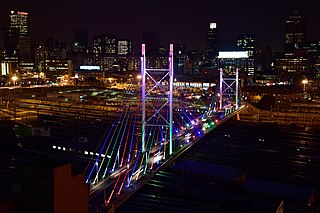
Johannesburg is the most populous city in South Africa, classified as a megacity; it is one of the 100 largest urban areas in the world. According to Demographia, the Johannesburg–Pretoria urban area is the 26th-largest in the world in terms of population, with 14,167,000 inhabitants. It is the provincial capital and largest city of Gauteng, which is the wealthiest province in South Africa. Johannesburg is the seat of the Constitutional Court, the highest court in South Africa. Most of the major South African companies and banks have their head offices in Johannesburg. The city is located within the mineral-rich Witwatersrand hills, the epicentre of the international-scale mineral, gold and (specifically) diamond trade.

South Africa occupies the southern tip of Africa, its coastline stretching more than 2,850 kilometres from the desert border with Namibia on the Atlantic (western) coast southwards around the tip of Africa and then northeast to the border with Mozambique on the Indian Ocean. The low-lying coastal zone is narrow for much of that distance, soon giving way to a mountainous escarpment that separates the coast from the high inland plateau. In some places, notably the province of KwaZulu-Natal in the east, a greater distance separates the coast from the escarpment. Although much of the country is classified as semi-arid, it has considerable variation in climate as well as topography. The total land area is 1,220,813 km2 (471,359 sq mi). It has the 23rd largest Exclusive Economic Zone of 1,535,538 km2 (592,875 sq mi).


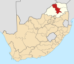
Limpopo is the northernmost province of South Africa. It is named after the Limpopo River, which forms the province's western and northern borders. The capital and largest city in the province is Polokwane, while the provincial legislature is situated in Lebowakgomo.
Carletonville is a town in Gauteng and the seat of the Merafong City Local Municipality in the West Rand District Municipality in Gauteng, South Africa, just north of the richest gold-mining area in the world. At 3,749 m, Western Deep Levels holds the record for the world's deepest gold mine.
Lephalale, also known as Ellisras, is a coal mining town in the Limpopo province of South Africa immediately east of the Waterberg Coalfield. The town was established as Ellisras in 1960 and named after Patrick Ellis and Piet Erasmus who settled on a farm there in the 1930s. In 2002, Ellisras was renamed Lephalale by the provincial government of Limpopo, after the main river that crosses the municipality. Lephalale is divided into three main subsections, Ellisras, Onverwacht and Marapong. Lephalale is derived from the setswana language meaning "to flow".

Vaalwater is a small town situated on the Mokolo River in the Limpopo province of South Africa.

Mokopane, also known as Potgietersrus, is a town in the Limpopo province of South Africa.
Musina, also known as Messina, is the northernmost town in the Limpopo province of South Africa. It is located near the confluence of the Limpopo River with the Sand River and the border to Zimbabwe with a population of between 20,000 and 40,000. Iron ore, coal, magnetite, graphite, asbestos, diamonds, semi-precious stones and copper are mined in the region.
Hoedspruit is a town situated at the foot of the Klein Drakensberg, in the Limpopo province of South Africa, on the railway line from Tzaneen to Kaapmuiden.

Phalaborwa is a town in the Mopani District Municipality, Limpopo province, South Africa.

Tzaneen is a large tropical garden town situated in the Mopani District Municipality of the Limpopo province in South Africa. It is situated in a high rainfall fertile region with tropical and subtropical agriculture taking place in a 20,000 square kilometres (7,700 sq mi) region. It is Limpopo's second largest town after Polokwane.
The Venetia Diamond Mine is South Africa's largest producer of diamonds, since 1995. It is situated close to the South African town of Alldays in the Limpopo province and is located within the 360 km² Venetia Limpopo Nature Reserve.

Concor Holdings (Proprietary) Limited. is a South African construction and mining services company. It is active throughout Southern Africa, involved in civil engineering, buildings, roads and mining projects. Concor returned as an independent brand in late 2016.

Mapungubwe National Park is a national park in the Limpopo Province, South Africa. The park protects the historical site of Mapungubwe Hill, which was the capital of the Kingdom of Mapungubwe, as well as the wildlife and riverine forests along the Limpopo River. The Mapungubwe Hill was the site of a community dating back to the Iron Age. Evidence has shown that it was a prosperous community. Archaeologists also uncovered the famous Golden Rhinoceros of Mapungubwe figurine from the site.

Aggeneys is a mining town established in 1976 on a farm of that name, situated between Pofadder and Springbok in the Northern Cape, South Africa.

Greater Mapungubwe Transfrontier Conservation Area is a cultural TFCA, formerly known as the Limpopo–Shashe Transfrontier Conservation Area.
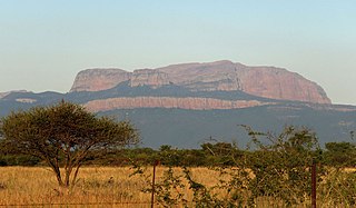
The Blouberg, meaning "Blue Mountain" in Dutch, is a range of mountains in the Limpopo Province, at the far north of South Africa. It is located in Blouberg Local Municipality, Capricorn District. The mountain is entrenched in the history of the local Northern Sotho people, and they have different names for its various parts.
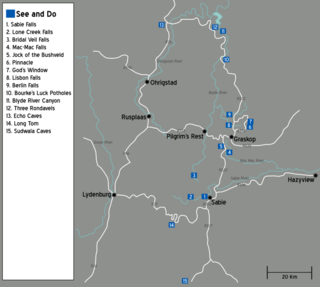
The Panorama Route is a scenic road in South Africa connecting several cultural and natural points of interest. The route, steeped in the history of South Africa, is in Mpumalanga province, centred around the Blyde River Canyon, the world's third largest canyon. It features numerous waterfalls, one of the largest afforested areas in South Africa, and several natural landmarks. The route starts at the foot of the Long Tom Pass just outside Lydenburg, following the natural descent from the Great Escarpment to the Lowveld, and ending at the border of the Mpumalanga and Limpopo provinces near the Echo Caves.