Vollmershain

Last updated
Vollmershain
Location of Vollmershain within Altenburger Land district
Vollmershain in ABG.pngGöhrenHaselbach
Germany adm location map.svg
Red pog.svg
Vollmershain
Thuringia location map.svg
Red pog.svg
Vollmershain
Coordinates: 50°51′19″N12°17′18″E / 50.85528°N 12.28833°E / 50.85528; 12.28833 Coordinates: 50°51′19″N12°17′18″E / 50.85528°N 12.28833°E / 50.85528; 12.28833
Country Germany
State Thuringia
District Altenburger Land
Municipal assoc. Oberes Sprottental
Government
   Mayor (202228) Gerd Junghanns [1]
Area
  Total5.00 km2 (1.93 sq mi)
Elevation
250 m (820 ft)
Population
 (2020-12-31) [2]
  Total310
  Density62/km2 (160/sq mi)
Time zone UTC+01:00 (CET)
  Summer (DST) UTC+02:00 (CEST)
Postal codes
04626
Dialling codes 034496
Vehicle registration ABG
Website www.vollmershain.de

Vollmershain is a municipality in the Verwaltungsgemeinschaft of Oberes Sprottental in the Thuringian landkreis of Altenburger Land in Germany.

Contents

Geography

The town's site

The village of Vollmershain is located along 4 km of the Sprotte. The highest part of the community is 306.2 m high on the side of the Mühlberg (308.1 m).

Neighbouring communities

Other municipalities near Vollmershain are Heukewalde, Jonaswalde, Posterstein, Nöbdenitz, Thonhausen, and the Weißbach district of Schmölln in the Landkreis of Altenburger Land.

History

Related Research Articles

Altenburger Land is a district in Thuringia, Germany. It is bounded by the district of Greiz, the Burgenlandkreis (Saxony-Anhalt), and the districts Leipzig, Mittelsachsen and Zwickau in Saxony. The district is a member of the Central German Metropolitan Region.

<span class="mw-page-title-main">Dobitschen</span> Municipality in Thuringia, Germany

Dobitschen is a municipality in the Altenburger Land district, in the far eastern part of Thuringia, Germany. It borders on the municipalities Schmölln, Göllnitz, Mehna and Starkenberg. It is subdivided into the Ortsteile Dobitschen, Meucha, Pontewitz and Rolika.

<span class="mw-page-title-main">Lucka</span> Town in Thuringia, Germany

Lucka is a town in the Thuringian landkreis of Altenburger Land.

<span class="mw-page-title-main">Schmölln</span> Town in Thuringia, Germany

Schmölln is a town in Thuringia, Germany, landkreis of Altenburger Land. It lies on the river Sprotte.

<span class="mw-page-title-main">Jonaswalde</span> Municipality in Thuringia, Germany

Jonaswalde is a municipality in the Thuringian district of Altenburger Land. It belongs to the Verwaltungsgemeinschaft of Oberes Sprottental.

<span class="mw-page-title-main">Rückersdorf, Thuringia</span> Municipality in Thuringia, Germany

Rückersdorf is a municipality in the eastern part of the Thuringian landkreis of Greiz and belongs to the Verwaltungsgemeinschaft of Wünschendorf/Elster.

<span class="mw-page-title-main">Heyersdorf</span> Municipality in Thuringia, Germany

Heyersdorf is a municipality in the Thuringian district of Altenburger Land.

<span class="mw-page-title-main">Heukewalde</span> Municipality in Thuringia, Germany

Heukewalde is a German municipality in the Thuringian Landkreis of Altenburger Land. It belongs to the Verwaltungsgemeinschaft of Oberes Sprottental.

<span class="mw-page-title-main">Posterstein</span> Municipality in Thuringia, Germany

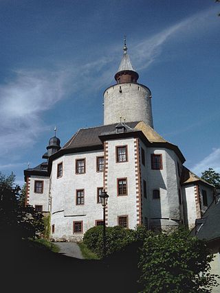
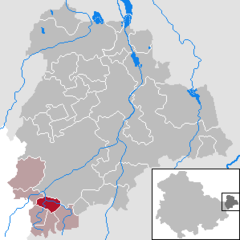
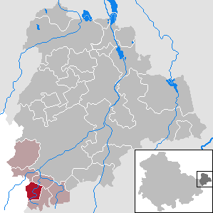
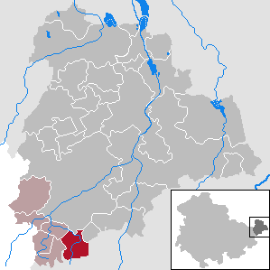
Posterstein is a German municipality in the Thuringian Landkreis of Altenburger Land.

<span class="mw-page-title-main">Paitzdorf</span> Municipality in Thuringia, Germany

Paitzdorf is a German municipality in the Thuringian Landkreis of Greiz. It belongs to the Verwaltungsgemeinschaft of Wünschendorf/Elster.

<span class="mw-page-title-main">Thonhausen</span> Municipality in Thuringia, Germany

Thonhausen is a municipality in the district of Altenburger Land in Thuringia, Germany. It belongs to the Verwaltungsgemeinschaft of Oberes Sprottental.

<span class="mw-page-title-main">Starkenberg</span> Municipality in Thuringia, Germany

Starkenberg is a municipality in the district Altenburger Land, in Thuringia, Germany. On 1 December 2008, it incorporated the former municipalities Naundorf and Tegkwitz.

<span class="mw-page-title-main">Langenleuba-Niederhain</span> Municipality in Thuringia, Germany

Langenleuba-Niederhain is a municipality in the district Altenburger Land, in Thuringia, Germany.

<span class="mw-page-title-main">Mehna</span> Municipality in Thuringia, Germany

Mehna is a municipality in the district Altenburger Land, in Thuringia, Germany.

<span class="mw-page-title-main">Nobitz</span> Municipality in Thuringia, Germany

Nobitz is a municipality in the district Altenburger Land, in Thuringia, Germany. The nearby Nobitz airfield was used by Ryanair for flights to and from London Stansted between 2003 and 2011.

<span class="mw-page-title-main">Rositz</span> Municipality in Thuringia, Germany

Rositz is a municipality in the district Altenburger Land, in Thuringia, Germany.

<span class="mw-page-title-main">Treben</span> Municipality in Thuringia, Germany

Treben is a municipality in the district Altenburger Land, in Thuringia, Germany.

<span class="mw-page-title-main">Windischleuba</span> Municipality in Thuringia, Germany

Windischleuba is a municipality in the district Altenburger Land, in Thuringia, Germany.

Altenburger Land I is an electoral constituency represented in the Landtag of Thuringia. It elects one member via first-past-the-post voting. Under the current constituency numbering system, it is designated as constituency 43. It covers the western part of Altenburger Land.

Altenburger Land II is an electoral constituency represented in the Landtag of Thuringia. It elects one member via first-past-the-post voting. Under the current constituency numbering system, it is designated as constituency 44. It covers the eastern part of Altenburger Land.

References

  1. Gewählte Bürgermeister - aktuelle Landesübersicht, Freistaat Thüringen, accessed 10 November 2022.
  2. "Bevölkerung der Gemeinden, erfüllenden Gemeinden und Verwaltungsgemeinschaften in Thüringen Gebietsstand: 31.12.2020". Thüringer Landesamt für Statistik (in German). June 2021.