Heyersdorf

Last updated
Heyersdorf
Location of Heyersdorf within Altenburger Land district
Heyersdorf in ABG.pngGöhrenHaselbach
Germany adm location map.svg
Red pog.svg
Heyersdorf
Thuringia location map.svg
Red pog.svg
Heyersdorf
Coordinates: 50°50′N12°20′E / 50.833°N 12.333°E / 50.833; 12.333 Coordinates: 50°50′N12°20′E / 50.833°N 12.333°E / 50.833; 12.333
Country Germany
State Thuringia
District Altenburger Land
Government
   Mayor (202127) Wilfried Koch [1]
Area
  Total3.78 km2 (1.46 sq mi)
Elevation
290 m (950 ft)
Population
 (2020-12-31) [2]
  Total114
  Density30/km2 (78/sq mi)
Time zone UTC+01:00 (CET)
  Summer (DST) UTC+02:00 (CEST)
Postal codes
04626
Dialling codes 03762
Vehicle registration ABG

Heyersdorf is a municipality in the Thuringian district of Altenburger Land.

Contents

Geography

Heyersdorf is located near the municipalities of Ponitz, the city of Schmölln, and Thonhausen in the district of Altenburger Land; as well as near the city of Crimmitschau in the Saxon district of Zwickauer Land.

History

Until 1920, Heyersdorf was part of the Kingdom of Saxony.

Politics

Together with Ponitz, Heyersdorf is the assigning municipality for Gößnitz.

Business and infrastructure

Heyersdorf is located on Bundesautobahn 4.

Twin towns

Heyersdorf is twinned with:

Related Research Articles

<span class="mw-page-title-main">Dobitschen</span> Municipality in Thuringia, Germany

Dobitschen is a municipality in the Altenburger Land district, in the far eastern part of Thuringia, Germany. It borders on the municipalities Schmölln, Göllnitz, Mehna and Starkenberg. It is subdivided into the Ortsteile Dobitschen, Meucha, Pontewitz and Rolika.

<span class="mw-page-title-main">Göllnitz</span> Municipality in Thuringia, Germany

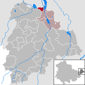
Göllnitz is a municipality in the district Altenburger Land, in Thuringia, Germany.

<span class="mw-page-title-main">Schmölln</span> Town in Thuringia, Germany

Schmölln is a town in Thuringia, Germany, landkreis of Altenburger Land. It lies on the river Sprotte.

<span class="mw-page-title-main">Jonaswalde</span> Municipality in Thuringia, Germany

Jonaswalde is a municipality in the Thuringian district of Altenburger Land. It belongs to the Verwaltungsgemeinschaft of Oberes Sprottental.

<span class="mw-page-title-main">Rückersdorf, Thuringia</span> Municipality in Thuringia, Germany

Rückersdorf is a municipality in the eastern part of the Thuringian landkreis of Greiz and belongs to the Verwaltungsgemeinschaft of Wünschendorf/Elster.

<span class="mw-page-title-main">Vollmershain</span> Municipality in Thuringia, Germany

Vollmershain is a municipality in the Verwaltungsgemeinschaft of Oberes Sprottental in the Thuringian landkreis of Altenburger Land in Germany.

<span class="mw-page-title-main">Heukewalde</span> Municipality in Thuringia, Germany

Heukewalde is a German municipality in the Thuringian Landkreis of Altenburger Land. It belongs to the Verwaltungsgemeinschaft of Oberes Sprottental.

<span class="mw-page-title-main">Posterstein</span> Municipality in Thuringia, Germany

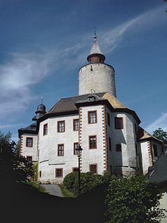
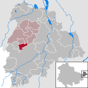
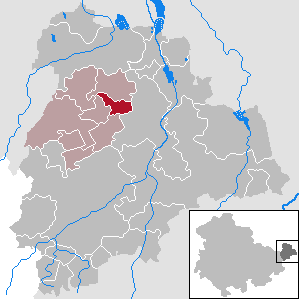
Posterstein is a German municipality in the Thuringian Landkreis of Altenburger Land.

<span class="mw-page-title-main">Paitzdorf</span> Municipality in Thuringia, Germany

Paitzdorf is a German municipality in the Thuringian Landkreis of Greiz. It belongs to the Verwaltungsgemeinschaft of Wünschendorf/Elster.

<span class="mw-page-title-main">Thonhausen</span> Municipality in Thuringia, Germany

Thonhausen is a municipality in the district of Altenburger Land in Thuringia, Germany. It belongs to the Verwaltungsgemeinschaft of Oberes Sprottental.

<span class="mw-page-title-main">Starkenberg</span> Municipality in Thuringia, Germany

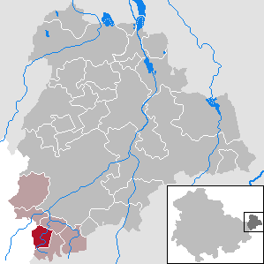
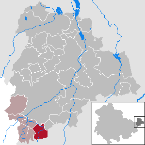
Starkenberg is a municipality in the district Altenburger Land, in Thuringia, Germany. On 1 December 2008, it incorporated the former municipalities Naundorf and Tegkwitz.

<span class="mw-page-title-main">Göhren, Thuringia</span> Municipality in Thuringia, Germany

Göhren is a municipality in the district of Altenburger Land, in Thuringia, Germany.

<span class="mw-page-title-main">Haselbach, Thuringia</span> Municipality in Thuringia, Germany

Haselbach is a municipality in the district Altenburger Land, in Thuringia, Germany.

<span class="mw-page-title-main">Fockendorf</span> Municipality in Thuringia, Germany

Fockendorf is a municipality in the district Altenburger Land, in Thuringia, Germany.

<span class="mw-page-title-main">Göpfersdorf</span> Municipality in Thuringia, Germany

Göpfersdorf is a municipality in the district of Altenburger Land, in Thuringia, Germany. Göpfersdorf consists of two districts.

<span class="mw-page-title-main">Lödla</span> Municipality in Thuringia, Germany

Lödla is a municipality in the district Altenburger Land, in Thuringia, Germany.

<span class="mw-page-title-main">Monstab</span> Municipality in Thuringia, Germany

Monstab is a municipality in the district Altenburger Land, in Thuringia, Germany. Monstab is located about 6 kilometers west from Altenburg.

<span class="mw-page-title-main">Ponitz</span> Municipality in Thuringia, Germany

Ponitz is a municipality in the district Altenburger Land, in Thuringia, Germany.

Altenburger Land I is an electoral constituency represented in the Landtag of Thuringia. It elects one member via first-past-the-post voting. Under the current constituency numbering system, it is designated as constituency 43. It covers the western part of Altenburger Land.

Altenburger Land II is an electoral constituency represented in the Landtag of Thuringia. It elects one member via first-past-the-post voting. Under the current constituency numbering system, it is designated as constituency 44. It covers the eastern part of Altenburger Land.

References

  1. Gewählte Bürgermeister - aktuelle Landesübersicht, Freistaat Thüringen, accessed 8 March 2022.
  2. "Bevölkerung der Gemeinden, erfüllenden Gemeinden und Verwaltungsgemeinschaften in Thüringen Gebietsstand: 31.12.2020". Thüringer Landesamt für Statistik (in German). June 2021.