W2W

Last updated

The W2W is the name of a cross-country cycle route in Northern England. It runs from Walney Island in Cumbria to Sunderland on the River Wear or Whitby (hence 'W2W', or Walney to Wear [and Whitby]).

Northern England Place in England

Northern England, also known as the North of England or simply the North, is the northern part of England, considered as a single cultural area. It extends from the Scottish border in the north to near the River Trent in the south, although precise definitions of its southern extent vary. Northern England approximately comprises three statistical regions: the North East, North West and Yorkshire and the Humber. These have a combined population of around 14.9 million as of the 2011 Census and an area of 37,331 km2. Northern England contains much of England's national parkland but also has large areas of urbanisation, including the conurbations of Greater Manchester, Merseyside, Teesside, Tyneside, Wearside, and South and West Yorkshire.

Walney Island island in the United Kingdom

Walney Island, also known as the Isle of Walney, is an island off the west coast of England, at the western end of Morecambe Bay in the Irish Sea. It is part of Barrow-in-Furness, separated from the mainland by Walney Channel, which is spanned by the Jubilee Bridge. Walney is the largest island of the Furness Islands group, both in population and size, as well as the largest English island in the Irish Sea. Its population at the 2011 UK Census was 10,651, distributed evenly across the island's two Wards of Walney North and Walney South.

Cumbria Ceremonial (geographic) county of England, UK

Cumbria is a ceremonial and non-metropolitan county in North West England. The county and Cumbria County Council, its local government, came into existence in 1974 after the passage of the Local Government Act 1972. Cumbria's county town is Carlisle, in the north of the county, and the only other major urban area is Barrow-in-Furness on the southwestern tip of the county.

Contents

History

The route was launched on 1 June 2005 to complement the popular Sea to Sea Cycle Route (C2C) that runs from Whitehaven to Sunderland. It is designed to be slightly harder and longer than this other route, totalling either 149 or 151 miles (240 or 243 km). When launched the route used sections of NCN Routes 72, 68 and 71 west of the Pennines. From Tan Hill to Sunderland a new Regional Route was created and given the number 20, with a blue background. In 2012, after improvements to meet National Cycle Network standards, it was upgrade to National Route 70. Route signs were changed to the number 70 with a red background [1] . Around the same time the sections on the route that had previously been Route 71 and 72 were re-signed as Route 70. In 2007 a southern branch from Barnard Castle to Whitby was added [2] . Orignaly classified as regional route 52, it was upgraded to National Cycle Route 165 in 2012. The Walney to Whitby route is 179 miles (288 km) [3] .

The Coast to Coast or Sea to Sea Cycle Route (C2C) is a 140 miles (230 km) cycle route opened in 1994. Combining sections of National Cycle Route 7 and National Cycle Route 71, it runs from Whitehaven or Workington on the west coast of Cumbria, and then crosses the Lake District and the Pennines in the north of England by using a variety of both on and off-road trails, ending on the north-east coast at Sunderland, Tyne and Wear, or at Tynemouth, Tyne and Wear. Claimed to be Great Britain's most popular long-distance cycle route, it is designed for the whole range of cyclists, from families to cycling club riders. Although a challenge with some hard climbs—the highest point being over 2,000 feet (610 m)—the C2C is completed by an average of between 12,800 and 15,000 cyclists every year.

Whitehaven coastal town and port, Cumbria, England

Whitehaven is a town and port on the west coast of Cumbria, near the Lake District National Park in England. Historically in Cumberland, it lies by road 38 miles (61 km) south-west of Carlisle and 45 miles (72 km) to the north of Barrow-in-Furness. It is the administrative seat of the Borough of Copeland, and has a town council for the parish of Whitehaven. The population of the town was 23,986 at the 2011 census.

National Cycle Network national cycling route network of the United Kingdom

The National Cycle Network (NCN) is the national cycling route network of the United Kingdom, which was established to encourage cycling throughout Britain, as well as for the purposes of bicycle touring. It was created by the charity Sustrans who were aided by a £42.5 million National Lottery grant. In 2017, the 16,575 mile network was used for over 786 million cycling and walking trips.

Route

W2W Route Map
Route 70
BSicon fENDEa.svg
0
Walney Island
BSicon fSTR+l.svg
BSicon fABZgr.svg
1
Route 700 leaves to E
BSicon fSTR.svg
BSicon fmTBHF.svg
2
Barrow in Furness
BSicon fSTR.svg
BSicon fmTBHF.svg
13
Ulverston
BSicon fSTRl.svg
BSicon fABZg+r.svg
14
Route 700 joins from E
BSicon fHST.svg
25
Cartmel
BSicon fSTR+l.svg
BSicon fABZgr.svg
25
Route 700 leaves to E
BSicon fSTRl.svg
BSicon fABZg+r.svg
27
Route 700 joins from E
BSicon fmTBHF.svg
27
Grange-over-Sands
BSicon fCONTgq.svg
BSicon fABZgr.svg
36
Route 700 leaves to S
BSicon fCONTgq.svg
BSicon fABZg+r.svg
38
Route 6 joins from S
BSicon fABZgl.svg
BSicon fCONTfq.svg
40
Route 6 leaves to N
BSicon fmTBHF.svg
43
Oxenholme
BSicon fCONTgq.svg
BSicon fABZg+r.svg
53
Route 68 joins from S
BSicon fHST.svg
63
Orton
BSicon fTEEl.svg
BSicon fCONTfq.svg
70
Routes 68 and 71 leave to N
BSicon fmTBHF.svg
76
Kirkby Stephen
BSicon fSTRdd.svg
82
BSicon fGIP.svg
87
Tan Hill
BSicon fCONTgq.svg
BSicon fABZgr.svg
Route 71 leaves to S
BSicon fHST.svg
95
Bowes
BSicon fBHF.svg
103
Barnard Castle
BSicon fSTRc2.svg
BSicon fABZ23.svg
BSicon fSTRc3.svg
Route 165
BSicon fSTR+1.svg
BSicon fdSTRc4.svg
BSicon fdSTRc1.svg
BSicon fSTR+4.svg
Route 70
Route 715 to N
106
BSicon fABZgl.svg
BSicon fSTR+r.svg
BSicon fHST.svg
117
Hamsterley
Croft-on-Tees
123
BSicon fHST.svg
BSicon fmTBHF.svg
BSicon fSTR.svg
121
Bishop Auckland
BSicon fSTR.svg
BSicon fSTRl.svg
BSicon fABZg+r.svg
126
Route 715 from S
Appleton Wiske
134
BSicon fHST.svg
BSicon fABZg+l.svg
BSicon fCONTfq.svg
133
Route 14 joins from N
Route 65 joins from S
140
BSicon fCONTgq.svg
BSicon fABZg+r.svg
BSicon fmTBHF.svg
135
Durham
Hutton Rudby
142
BSicon fHST.svg
BSicon fCONTgq.svg
BSicon fABZgr.svg
139
Route 14 leaves to S
Route 65 Leaves to N
143
BSicon fABZgl.svg
BSicon fCONTfq.svg
BSicon fSTR.svg
Great Ayton
150
BSicon fmTHST.svg
BSicon fCONTgq.svg
BSicon fABZg+r.svg
149
Route 1 joins from S
Route 168 to N
157
BSicon fTEEl.svg
BSicon fCONTfq.svg
BSicon fSTR.svg
Castleton
161
BSicon fmTHST.svg
BSicon fmTBHF.svg
150
Sunderland
Egton
171
BSicon fmTHST.svg
BSicon fABZg+l.svg
BSicon fCONTfq.svg
151
Route 7 joins from W
Whitby
179
BSicon fENDE.svg
BSicon fENDE.svg
152
Wearmouth
Route 1 to S
BSicon fCONTf.svg
BSicon fCONTf.svg
Route 1 to N

The W2W is a Y shaped route with one western leg from Walney to Barnard Castle, and two eastern legs Barnard Castle to Sunderland (northern) and Barnard Castle to Whitby (Southern).

Barnard Castle town in Durham, Britain

Barnard Castle is a market town in Teesdale, County Durham, England. It is named after the castle around which it was built. It is the main settlement in the Teesdale area, and is a popular tourist destination. The Bowes Museum has the best collection of European fine and decorative arts in the North of England, housed in a magnificent 19th-century French-style chateau. Its most famous exhibit is the 18th-century Silver Swan automaton, though art includes work by Goya and El Greco.

Western Leg

103 miles (166 km) Walney to Barnard Castle

Near Tan Hill W2W - Tan Hill to Sleightholme - geograph.org.uk - 365356.jpg
Near Tan Hill
Irish Sea Sea which separates the islands of Ireland and Great Britain

The Irish Sea separates the islands of Ireland and Great Britain; linked to the Celtic Sea in the south by St George's Channel, and to the Inner Seas off the West Coast of Scotland in the north by the Straits of Moyle. Ireland and all countries that comprise the United Kingdom are on its shoreline: Scotland on the north, England on the east, Wales on the southeast, and Northern Ireland and the Republic of Ireland on the west.

Barrow-in-Furness town and seaport in the county of Cumbria, England

Barrow-in-Furness is a town and borough in Cumbria, North-West England. Historically part of Lancashire, it was incorporated as a municipal borough in 1867 and merged with Dalton-in-Furness Urban District in 1974 to form the Borough of Barrow-in-Furness. At the tip of the Furness peninsula, close to the Lake District, it is bordered by Morecambe Bay, the Duddon Estuary and the Irish Sea. In 2011, Barrow's population was 57,000, making it the second largest urban area in Cumbria after Carlisle, although it is geographically closer to the whole of Lancashire and most of Merseyside. Natives of Barrow, as well as the local dialect, are known as Barrovian.

Furness peninsula and region in south Cumbria, England

Furness is a peninsula and region of Cumbria in northwestern England. Together with the Cartmel Peninsula it forms North Lonsdale, historically an exclave of Lancashire.

North Eastern Leg

49 miles (79 km) Barnard Castle to Sunderland

Near Brancepeth Brandon to Bishop Auckland path, near Brancepeth - geograph.org.uk - 124385.jpg
Near Brancepeth
Hamsterley, Bishop Auckland village and civil parish in County Durham, England

Hamsterley is a village in County Durham, England. It is situated a few miles west of Bishop Auckland.

Durham, England City in England

Durham is a historic city and the county town of County Durham in North East England. The city lies on the River Wear, to the south-west of Sunderland, south of Newcastle upon Tyne and to the north of Darlington. Founded over the final resting place of St Cuthbert, its Norman cathedral became a centre of pilgrimage in medieval England. The cathedral and adjacent 11th-century castle were designated a World Heritage Site by UNESCO in 1986. The castle has been the home of Durham University since 1832. HM Prison Durham is also located close to the city centre. City of Durham is the name of the civil parish.

Bishop Auckland Market town and civil parish in County Durham, England

Bishop Auckland is a market town and civil parish in County Durham in north east England. It is located about 12 miles (19 km) northwest of Darlington, 12 miles (19 km) southwest of Durham and 5 miles (8 km) southeast of Crook at the confluence of the River Wear with its tributary the River Gaunless. According to the 2001 census, Bishop Auckland has a population of 24,392, increasing to 25,455 at the 2016 estimate.

South Eastern Leg

76 miles (122 km) Barnard Castle to Whitby

The Durham Dales is the name given to a large area of landscape in the west of County Durham, consisting primarily of the Durham portion of the North Pennines, in England.

Tees Valley Place in England

The Tees Valley is a city region in the North East of England around the lower reaches of the River Tees.

Croft-on-Tees village and civil parish in North Yorkshire, UK

Croft-on-Tees is a village and civil parish in the Richmondshire district of North Yorkshire, England. It has also been known as Croft Spa, and from which the former Croft Spa railway station took its name. It lies 11 miles (18 km) north-north west of the county town of Northallerton.

Footnotes

  1. "W2W renumbered to Route 70 / 165". W2W cycle route. Retrieved 23 January 2018.
  2. Sustrans (2007). Discover Three Rivers : cycle routes map. Bristol: Sustrans. ISBN   1901389685.
  3. "Walney to Wear [and Whitby] (W2W) - Map". Sustrans. Retrieved 23 January 2018.
  4. "W2W — Grange Promenade now open for cycling". cyclingw2w.info.
Map all coordinates using: OpenStreetMap  
Download coordinates as: KML  ·  GPX

Coordinates: 54°27′59″N2°06′05″W / 54.4663°N 2.1013°W / 54.4663; -2.1013 (W2W cycle route)

Related Research Articles

Tyne and Wear County of England

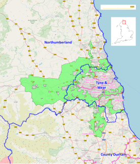
Tyne and Wear is a metropolitan county in the North East region of England around the mouths of the rivers Tyne and Wear. It came into existence in 1974 after the passage of the Local Government Act 1972. It consists of the five metropolitan boroughs of South Tyneside, North Tyneside, City of Newcastle upon Tyne, Gateshead and City of Sunderland. It is bounded on the east by the North Sea, and has borders with Northumberland to the north and County Durham to the south.

Trans Pennine Trail

The Trans Pennine Trail is a long-distance path running from coast to coast across Northern England entirely on surfaced paths and using only gentle gradients. It forms part of European walking route E8 and is part of the National Cycle Network as Route 62.

Ryhope village along the southern boundary of the City of Sunderland, in Tyne and Wear, North East England

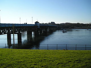
Ryhope is a coastal village along the southern boundary of the City of Sunderland, in Tyne and Wear, North East England. With a population of approximately 14,000, measured at 10.484 in the 2011 census, Ryhope is 2.9 miles to the centre of Sunderland, 2.8 miles to the centre of Seaham, and 1.2 miles from the main A19.

Rookhope village in United Kingdom

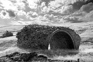
Rookhope is a village in County Durham, in England. A former lead and fluorspar mining community, it first existed as a group of cattle farms in the 13th Century. It is situated in the Pennines to the north of Weardale. W. H. Auden once called Rookhope 'the most wonderfully desolate of all the dales'.

Weardale Way is a footpath that follows the River Wear in the North East of England. It is 73 miles long, starting at the Lindesfarne Memorial on the sea wall at Roker. It then passes through Chester-le-Street, Durham, Bishop Auckland, Wolsingham and Stanhope. The path ends outside the Post Office in the village of Wearhead in County Durham.

The Pennine Cycleway is a Sustrans-sponsored route in the Pennines range in northern England, an area often called the "backbone of England". The route passes through the counties of Derbyshire, West Yorkshire, Lancashire, North Yorkshire, Cumbria and Northumberland. It is part of the National Cycle Network (NCN). Sustrans founder John Grimshaw calls it 'the best National Cycle Network route of the lot'.

Teesdale Way

The Teesdale Way is a long distance walk between the Cumbrian Pennines and the North Sea coast of North Yorkshire in England. The walk is 100 miles (160 km) in length; it links in with other long distance walks such as the Pennine Way and the E2 European Walk between Harwich and Stranraer.

National Cycle Route 1 route of the National Cycle Network in the UK

National Cycle Route 1 is a route of the National Cycle Network, running from Dover to Shetland. The 1,695-mile-long (2,728 km) cycle-path is located in the United Kingdom.

National Cycle Route 14 forms part of the National Cycle Network in North East England. It connects Darlington in County Durham with South Shields on the River Tyne. The route has currently (2016) a length of 86 miles (138 km). Much of it uses paths along disused railway lines and is thus free from motor traffic.

National Cycle Route 72

National Route 72 of the National Cycle Network, in North England is also called "Hadrian's Cycleway". It starts at Kendal and makes its way around the Cumbrian coast via Barrow-in-Furness and Whitehaven to Silloth, and then across the country through Carlisle via Newcastle upon Tyne to Tynemouth at the northern shore or to South Shields at the Tynes south shore, where the cycleway ends at Arbeia Roman Fort. Much of its route is very close to Hadrian's Wall.

River Wear river in North East England

The River Wear in North East England rises in the Pennines and flows eastwards, mostly through County Durham to the North Sea in the City of Sunderland. At 60 mi (97 km) long, it is one of the region's longest rivers, wends in a steep valley through the cathedral city of Durham and gives its name to Weardale in its upper reach and Wearside by its mouth.

Way of the Roses Coast to Coast cycle route from Morecambe in Lancashire to Bridlington in Yorkshire

The Way of the Roses is the newest of Great Britain's coast-to-coast, long-distance cycle routes and is based on minor roads, disused railway lines and specially constructed cycle paths. It lies entirely within the counties of Lancashire and Yorkshire, crossing the Yorkshire Dales and the Yorkshire Wolds in the north of England, passing through the historic cities of Lancaster and York and scenic towns and villages including Settle, Pateley Bridge and Ripon.

National Cycle Route 65 Route of the National Cycle Network in the UK

National Cycle Network (NCN) Route 65 is a Sustrans National Route that runs from Hornsea on the North Sea Coast of The East Riding of Yorkshire via Hull and York to Middlesbrough. It is fully open and signed.

North East Green Belt

The North East Green Belt, also known as the Tyne & Wear Green Belt, is a non-statutory green belt environmental and planning policy that regulates the rural space in part of the North East region of England. It is centred on the county of Tyne and Wear, with areas of belt extending into Northumberland and County Durham. The belt functions to protect surrounding towns and villages outside the Tyneside/Newcastle-upon-Tyne and Wearside/Sunderland conurbations from further convergence. It is managed by local planning authorities on guidance from central government.

National Cycle Network (NCN) Route 70 is a Sustrans National Route that runs from Walney Island in Cumbria to Sunderland. The route is fully open and signed. From end to end the route is 149 miles (240 km), but two sections are shared with other NCN routes leaving Route 70 at 128 miles (206 km).

National Cycle Route 688 National Cycle Network (NCN) Route 688 is a Sustrans National Route that runs from Winterburn to Linton-on-Ouse[2]. It is 55 miles (89 km).

National Cycle Network (NCN) Route 688 is a Sustrans National Route that runs from Winterburn to Linton-on-Ouse. It is 55 miles (89 km), fully open and signed.

National Cycle Route 165 National Cycle Network (NCN) Route 165 is a Sustrans National Route that runs from Barnard Castle to Whitby.

National Cycle Network (NCN) Route 165 is a Sustrans National Route that runs from Barnard Castle to Whitby. The route is 74 miles (119 km) in length and is fully open and signed in both directions.