Hutt Valley portal of the Wainuiomata Tunnel | |
Overview | |
---|---|
Location | Lower Hutt, Wellington, New Zealand |
Coordinates | 41°14′49.53″S174°55′26.08″E / 41.2470917°S 174.9239111°E |
Status | abandoned as road tunnel, converted to utility tunnel |
Start | Tunnel Grove, Gracefield, Lower Hutt |
End | Waiu Street, Wainuiomata, Lower Hutt |
Operation | |
Work begun | January 25, 1932 |
Owner | Greater Wellington Regional Council |
Traffic | pedestrian/cyclist and automotive (planned) |
Character | road (planned); utility (current) |
Technical | |
No. of lanes | 2 (planned) |
Highest elevation | 100 metres (328 ft) |
Lowest elevation | 34 metres (112 ft) |
Tunnel clearance | 16 feet (4.9 m) |
Width | 25 feet 6 inches (7.77 m) |
Grade | 1 in 15 |
Route map | |
![]() |
The Wainuiomata Tunnel was planned to improve access to the Wainuiomata Valley in the Wellington region of New Zealand’s North Island as part of a scheme to commence residential development there in the 1930s. Construction started in 1932 but was halted a couple of years later when only partly completed due to a lack of funds brought about by economic depression.
The tunnel was never opened to road traffic, and other than a brief stint of military service during World War II, remained unused until sold in 1975. Thereafter it was completed as a utility tunnel, initially carrying only a water pipe, but later other services were added.
Wainui-o-Mata Development Limited was formed for the purpose of developing the Wainuiomata Valley through the acquisition of land, subdivision, and sale of residential lots. An important part of the project was the construction of a tunnel linking the Hutt Valley and Wainuiomata Valley for improving access to the new settlement. [1]
Like the then recently completed Mount Victoria Tunnel in Wellington, the Wainuiomata Tunnel was designed to allow for two lanes of opposing general vehicular traffic with a raised pedestrian pathway on the north side. [2] Starting from a point near the industrial park at Gracefield, it would rise on a gradient of 1 in 15 to emerge at the foot of the hills in Wainuiomata near the existing hill road. [1] [3] It was to be 26 feet 6 inches (8.08 m) wide, 18 feet (5.5 m) high, and have a length of 49 chains (3,200 ft; 990 m). [4] The footpath would be 4 feet (1.2 m) wide, 3 feet (0.91 m) above the floor of the tunnel. [3]
The Railways Department became particularly interested in the tunnel and realised it would be advantageous for them to obtain the right to access the tunnel before their competitors were able to establish competing services. To this end, they entered into an agreement on 1 October 1928 with Wainuiomata Development for the sole right to operate “motor or electrical passenger transportation” through the tunnel between Wainuiomata and Wellington City, Lower Hutt, or Petone. The agreement also committed the parties to the following: [5]
Wainuiomata Development called for tenders to construct the tunnel in October 1931 [2] and awarded a contract for the same to Templeton Tunnel Construction Company. [4] [6]
Work commenced on 25 January 1932 [7] using subsidised labour from a work relief scheme to find employment for those affected by the economic depression. [8] [9] A workers camp was erected; flat land was cleared around the portal on which buildings were erected for the workshop and powerhouse. Plant included an electric motor for running air compressors, ventilation, and the equipment used to apply the concrete lining to the completed tunnel walls. Formwork for the tunnel portal was assembled and the hillside prepared for the building of the portal. Additional men were due to start work at the site after 1 February. [7]
Unlike the standard practice for tunnel construction in which at least two faces are advanced simultaneously (either end of the tunnel), it was decided in the case of the Wainuiomata Tunnel that work would only take place from the western end towards Wainuiomata. This was done for drainage; on such a steep grade it was easier to work uphill and let the water that flowed into the tunnel drain out naturally rather than have to pump it out (as would be the case if they had worked downhill from the Wainuiomata end). [10] It was noted, however, that if needed up to three 8-hour shifts per day could be deployed at both ends of the tunnel to improve progress. The men working in the tunnel found that the ground they were excavating was not ideal for tunnelling, and often encountered soft earth or “rotten” rock. [4]
The first pass on the tunnel shaft was not to excavate down to the full depth of the completed tunnel. Rather, an additional 3 feet (0.91 m) of earth was to be removed before the sealed roadway could be laid through the tunnel. [3]
Various reports from the early 1930s noted steady progress. [3] [4] However, as the financing of works related to the Wainuiomata development relied in part on the sale of land in the valley, the effect of economic depression at the time was to deny the Company revenue from this source as real estate activity slowed, depriving it of the funds it needed to continue the development. Consequently, the Company temporarily suspended all work on the tunnel in April 1934 as it sought alternative finance to restart the project. [11] These efforts were to no avail, and it was noted in 1936 that the Company had “ceased practically all activity” at the tunnel construction site [12] having completed 17 chains (1,100 ft; 340 m) (roughly one third) of its total length, with about 15 chains (990 ft; 300 m) of that lined. [1]
During the 1935 general election campaign in November of that year, the Labour candidate for the Hutt electorate, Walter Nash, criticised his opponent for supporting the expenditure of unemployment subsidies on the improvement of access to Wainuiomata including work on both the widening of the hill road and the driving of the tunnel through the hill. [13]
The Quartermaster-General approached the Wainuiomata Development Company in 1942 on behalf of the New Zealand Army to lease the tunnel. Their intention was to use the tunnel primarily for the storage of explosives but potentially also as an air raid shelter. They sought a term covering the duration of the war plus six months, to which the Company was agreeable, on the proviso that the Company be able to terminate the agreement with six months notice if they decided to resume work on the tunnel and it was not required for “essential war purposes”. The lease covered the land and buildings at the tunnel, at a rate of £156 per annum, commencing on 2 April 1942.
Having obtained the Company’s permission, the Army authorised modifications to be made at the tunnel for the preparation of the magazine on 8 April 1942. Work included installation of electric lighting, an upgrade of the drainage, erection of a security fence enclosing the entire tunnel section with a gate allowing truck access, levelling inside the tunnel to make it suitable for stacking the explosives, and the building of a loading dock to facilitate the transfer of goods to and from the trucks. The Public Works Department handed over the completed magazine to the Army on 8 June 1942.
Early termination of the lease was requested when the Quartermaster-General advised the Company that the Army intended to vacate the site effective 15 September 1944. This date was missed, and it was not until 26 February 1945 that possession was relinquished, once all stores had been removed and restoration works completed. [14]
After the suspension of construction on the tunnel in the 1930s, there was optimism through to the 1950s that it would be restarted at some point, particularly after residential development commenced at Wainuiomata in 1941.
A conference was held around 1956 at which the Public Works Department, the Hutt City Council, and the development company were represented to consider the future of the tunnel. It was agreed that the tunnel, in its present form, was unsuitable for use either by road or rail traffic. The amount of space allowed for the roadway was not wide enough for the requirements of contemporary road traffic. It was estimated that the tunnel could be completed to suit requirements for around £600,000 (in 1966), which would likely involve the removal of the existing lining so the size of the bore could be increased. [1]
During the 1963 general election campaign, the Labour candidate for Petone, Michael Moohan, stated that the issue of the Wainuiomata Tunnel was a “dead duck”. In response to a question from a constituent, he noted that the tunnel was not wide enough for modern traffic requirements and was too steep to be turned into a rail tunnel. [15]
By the 1970s, replacement of the water supply pipe that was running through the Waiwhetu Tunnel had become necessary. The Wellington Regional Water Board purchased Wainuiomata Tunnel from Wainuiomata Development Company in 1975, intending to use it for a much larger, replacement water pipe. [16] Even after this acquisition there was opposition to the proposal to lay a water main through the tunnel, as such action would preclude its completion as a road tunnel at some point in the future.
A contract for the completion of the tunnel was let to Codelfa Construction NZ Limited. They started work early in 1980, reaching Wainuiomata in September of that year. The section of tunnel excavated at this time was completed to a smaller width of 2.4 metres (7 ft 10 in). [16]
After the tunnel was abandoned as a means of providing road access to Wainuiomata, other routes gained prominence. Wainuiomata Road was upgraded and presently is the main access route at the southern end of the valley.
Another idea that gained popularity, especially as a way to provide a second road access route and an alternative to the hill road, [17] is a link between Wainuiomata and the suburb of Naenae in the Hutt Valley. [18] [19] The most likely option would be a road connecting Upper Fitzherbert Road, Wainuiomata, via a tunnel, to Seddon Street in Naenae.
Greater Wellington Regional Council is responsible for the tunnel, and also maintains the water supply pipe that runs through it. The tunnel also now carries a sewer pipeline and telecommunications cables.
When the Hutt City Council wanted to construct a new wastewater treatment plant at Seaview in the 1990s, they attempted to secure access to the Wainuiomata Tunnel to build the sewer pipeline to connect the new plant to Wainuiomata. As this wasn’t an option at the time, they were offered, and accepted, the alternative of the nearby smaller, and much older, Waiwhetu Tunnel that had previously been used for a water supply pipe. In 2001, negotiations between the Regional Council and Hutt City Council resulted in an agreement for the latter to be able to use the Wainuiomata Tunnel and some associated land for which an easement was granted for the installation of their sewer pipe. [20]
The tunnel is occasionally opened to the public for organised tours. [21]
The Hutt River flows through the southern North Island of New Zealand. It flows south-west from the southern Tararua Range for 56 kilometres (35 mi), forming a number of fertile floodplains, including Kaitoke, central Upper Hutt and Lower Hutt.
Wainuiomata is a large dormitory suburb of Lower Hutt, in the Wellington metropolitan area in New Zealand. Its population was estimated as being 19,840 as of June 2023, with a density of 1,600 people per km2. European settlement of Wainuiomata began in the 1850s with timber-felling and farming and began to grow in the 1920s. After World War 2 there was rapid population expansion, with Wainuiomata earning the nickname 'Nappy Valley' because of the large number of families with young children. From the late 1980s the economy slowed and the population decreased, but since about 2020 there has been a housing boom and corresponding increase in population. Wainuiomata is noted for being the origin of New Zealand's kōhanga reo movement.
The Wainuiomata River runs southwest through the Wainuiomata Valley located in the southern Remutaka Range in the North Island, New Zealand.
The Wairarapa Line is a secondary railway line in the south-east of the North Island of New Zealand. The line runs for 172 kilometres (107 mi), connects the capital city Wellington with the Palmerston North - Gisborne Line at Woodville, via Lower Hutt, Upper Hutt and Masterton.
Petone railway station is a dual platform, suburban railway station located in the Lower Hutt, New Zealand suburb of Petone. It is on the Hutt Valley section of the Wairarapa Line, 10.5 km (6.5 mi) north of Wellington, and is the junction for the Melling Branch to Melling, which diverges westward from the main line to the north of the station. The station is served by Metlink suburban services, operated by Transdev Wellington, to Wellington, Melling, Taita, Upper Hutt and Masterton.
The Hutt Valley Line is the electrified train service operated by Transdev Wellington on behalf of Metlink on the section of the Wairarapa Line railway between Wellington and Upper Hutt, New Zealand.
The Transmission Gully Motorway is a 27-kilometre-long (17-mile), four-lane motorway north of Wellington, New Zealand; it is part of the State Highway 1 route. Construction began on 8 September 2014 and completion was originally scheduled for April 2020, but contractual negotiations as well as difficulties resulting from the COVID-19 pandemic caused delays. The motorway was officially opened on 30 March 2022 and opened to public traffic the following day.
Waterloo railway station is a dual-platform suburban railway station located in Lower Hutt, New Zealand, and serving immediately the suburbs of Waterloo, Lower Hutt Central and Woburn. The station stands on the Hutt Valley section of the Wairarapa Line, 15.5 km (9.6 mi) north of Wellington. Trains stopping at Waterloo run to Wellington, Taita, Upper Hutt and Masterton, as well as to points in between. Waterloo serves as a major bus-rail interchange, connecting buses to and from central Lower Hutt, Naenae and Wainuiomata with trains to and from Wellington.
Multiple proposals have been made for a branch line railway to Wainuiomata as part of the Wellington commuter railway network. Despite strong local pressure at times during the 20th century, none of the proposals have come to fruition. There are currently (2021) no plans under consideration to build a rail line to Wainuiomata, although in 2021 a Christchurch-based property development company advertised townhouses in Wainuiomata as in "close proximity" to a non-existent Wainuiomata Train Station.
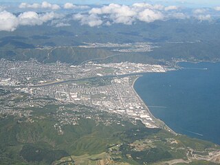
Lower Hutt is a city in the Wellington Region of New Zealand. Administered by the Hutt City Council, it is one of the four cities that constitute the Wellington metropolitan area.
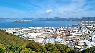
Gracefield is an industrial suburb of Lower Hutt City, located at the bottom of the North Island of New Zealand.
Seaview is an industrial suburb of the city of Lower Hutt, in Wellington, New Zealand. Situated on the eastern coast of the Hutt Valley, the suburb lies between Te Awa Kairangi / the Hutt River and Petone, and the bays of Eastbourne to the south. Seaview is a centre for bulk liquid fuel storage for the lower half of the North Island, and a site for heavy industry. It is also a base for support services for trucks and transportation businesses and the location of the wastewater treatment plant for drainage from the Hutt Valley. Seaview is home to the Port Road Drags, the longest-running street drag races in Australasia.
Hutt County was one of the former counties of New Zealand. It occupied the south-western corner of the North Island, extending south from the Waikanae River and lying to the west of the summits of the Rimutaka Ranges. The county's name arose from the fact that a large amount of its land area lay in the Hutt River catchment.
Water supply and sanitation in the Wellington region involves the provision of the "three waters" – drinking water, stormwater, and wastewater services in the Greater Wellington region.
Water supply in the Wellington region involves the provision of drinking water services in the Greater Wellington region of New Zealand.
Wainuiomata Regional Park is a regional park located near Wainuiomata, Lower Hutt in the Wellington Region of New Zealand. It is administered by Wellington Regional Council. The name of the park was changed from Wainuiomata Recreation Area to Wainuiomata Regional Park in January 2022.
Point Howard is a suburb on the eastern side of Wellington Harbour, in Lower Hutt, New Zealand.
Ernest Albert Barry was a New Zealand educator and politician. He was a Lower Hutt city councillor and was deputy mayor from 1977 to 1980.
The Waiwhetu artesian aquifer, sometimes referred to as the Hutt aquifer, is a pressurized zone of water-retaining sand, gravel and boulders beneath the Hutt Valley and Wellington Harbour in New Zealand. The aquifer provides about 40% of the public fresh water supply for Lower Hutt and Wellington city. Water from the Hutt River begins to flow underground south from Taita Gorge, then becomes pressurized under a seal of clay. Water is extracted from the pressurized area for public use, but concerns about overuse and damage by earthquakes have led to investigations of alternative sources of fresh water.