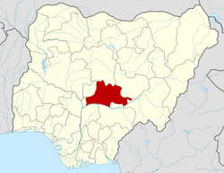
Wamba | |
---|---|
LGA and town | |
Nickname: Wamba | |
Motto: The Heartland of Cassava | |
Coordinates: 8°56′0″N8°36′0″E / 8.93333°N 8.60000°E | |
Country | Nigeria |
State | Nasarawa State |
Headquarters | Wamba |
Government | |
• Type | Democratic |
• Executive Chairman | Hon. Bala Asiru |
Time zone | UTC+1 (WAT) |
Wamba Local Government Areas of Nigeria Local Government Area is one of the 13 local government Areas in Nasarawa State, North-central Nigeria, with its headquarters situated in Wamba Town.
It has an estimated land area of 1,156 km2 and a population of about 72,894 based on the 2006 census estimates.
Wamba local government is an agrarian sub-state, it is known for casava, pidgeion pea, palm carnel and oil, productions respectively.
Wamba also has minerals deposit like lead, barite, tantalite, columbite, and gems such as Aquamarine and gold. Yet to be exploited officially.
Wamba is both heteroethnic heteroreligious, Among the nation's that make up the area are:
Arum, Atoro, Buh, Kantana, Kulere, Ninzom, Ninkada, Rindere, and Yashi.
Wamba Local government is renowned for the spectacular and beautiful Farin Ruwa Falls. One of the longest Cascades in Africa. It presents a long Cascade of white rapids from the Highlands of Plateau states down to the foothills, ending with the main attraction Farin Ruwa Falls, in Wamba Local government. [1]
The postal code of the area is 960. [2]
The summer months in Wamba are January through April, with March being the hottest month. From June to October is considered the cool season, with August being the coolest month. [3]
Nasarawa State is a state in the North Central region of Nigeria, bordered to the east by the states of Taraba and Plateau, to the north by Kaduna State, to the south by the states of Benue and Kogi, and to the west by the Federal Capital Territory. Named for the historic Nasarawa Emirate, the state was formed from the west of Plateau State on 1 October 1996. The state has thirteen local government areas and its capital is Lafia, located in the east of the state, while a key economic centre of the state is the Karu Urban Area—suburbs of Abuja—along the western border with the FCT.
Yenagoa is a Local Government Area and capital city of Bayelsa State, Southern Nigeria. It is located at the Niger-Delta region of the country at coordinates 4°55′29″N6°15′51″E.
Lafia is a city in Nigeria's North Central region. It is the capital and largest city of Nasarawa State, with a population of 509,300 inhabitants as of the 2021 census. And it's the Headquarter of Lafia Emirate Council.
Abdullahi Adamu is a Nigerian politician who was the governor of Nasarawa State in Nigeria from 29 May 1999 to 29 May 2007. He is a member and former national chairman of the ruling Party All Progressives Congress (APC).
Bebeji is a Local Government Area in Kano State, Nigeria. Its headquarters are in the town of Bebeji.
Kankia is a Local Government Area in Katsina State, Nigeria. and has its headquarters is in the town of Kankia on Kano - Katsina road A9 highway at12°32′57″N7°49′31″E.. Towns and villages that make up Kankia Local Government Area include Kafin Dangi, Sukuntuni, Rimaye, Sabuwar Duniya, Tafashiya, Gaza, Kafin-soli, and Kankia. The population of Kankia Local Government Area is estimated at 151,434 inhabitants at the 2006 census with the majority of the area’s dwellers being members of the Hausa and the Fulani ethnic divisions. The Hausa and the Fufulde languages are widely spoken in the area with Islam as the LGA’s most practiced religion. The paramount traditional ruler in Kankia LGA is the Hakimi Kankia while notable landmarks in the area include the Kankiya Iro School of Hecalth Technology, Kankia and the Kankia General Hospital. The postal code of the area is 822
Fagge is a Local Government Area in Kano State, Nigeria, within the state metropolitan. Its headquarters are in the suburb of Waje.
Sanga is a Local Government Area in southern Kaduna State, Nigeria. Its headquarters is in the town of Gbantu. The Local Government Council is chaired by Bisallah Malam. It has an area of 1,821 km2 and had a population of 151,485 as at the 2006 census. The postal code of the area is 801.
Kagarko is a Local Government Area in southern Kaduna State of Nigeria. Its headquarters are in the town of Kagarko. It has an area of 2,356 km2 and a population of 239,058 at the 2006 census. The Local Government Council is chaired by Nasara Rabo. The postal code is 802.
Karu is a Local Government Area in Nasarawa State, central Nigeria. It is close in proximity to the Federal Capital Territory of Nigeria. It has an area of 2,640 km2. Karu local government has its headquarters in New Karu town. It was originally built to house the capital's civil servants and lower income families, but had no running water or good sanitation system. Karu has grown in population beyond its original planned capacity. Ensure Administrative convenience and bring government closer to the grass root people, Karshi Development Area was created with its administrative secretariat at Uke.
Keffi Local Government Area and a traditional and commercial town in Nasarawa State, north central Nigeria. Its headquarters are in the town of Keffi. Keffi is 50 kilometers from Abuja. Nasarawa State university is located along the Keffi-Akwanga expressway.
Toto is a Local Government Area in Nasarawa State, Nigeria. Its headquarters is in the town of Toto.
Doma is a Local Government Area in Nasarawa State, Nigeria. Its headquarters are in the town of Doma. Doma LGA houses Special Forces Command, Federal Science and Technical College, Olam Rice Farm and Doma Dam.
Awe is a Local Government Area in Nasarawa State, Nigeria. The LGA's headquarters is in Awe Town. Awe has a population of 116,080 and total land mass is 2800
Keana is a town and Local Government Area in Nasarawa State, North Central, Nigeria. Its headquarters are in the town of Keana. It has an area of 1,048.1 km2 and a population of about 80,000. It is home to Federal Government Girls College, Keana.
Birnin Magaji/Kiyaw is a Local Government Area in Zamfara State, Nigeria. Its headquarters are in the town of Birnin Magaji in the north of the LGA at12°33′00″N6°49′00″E. The LGA is also named from the town of Kiyaw to the south.
The Nigerian National Assembly delegation from Nasarawa State comprises three Senators and five Representatives.
Farin Ruwa Falls is a waterfall found in the central region of Nigeria. It is among the highest waterfalls in Nigeria. It is significant among Africa's falls when the total height covered by the waterfall is considered.
The 2023 Nasarawa State gubernatorial election will take place on 18 March 2023, to elect the Governor of Nasarawa State, concurrent with elections to the Nasarawa State House of Assembly as well as twenty-seven other gubernatorial elections and elections to all other state houses of assembly. The election—which was postponed from its original 11 March date—will be held three weeks after the presidential election and National Assembly elections. Incumbent APC Governor Abdullahi Sule is eligible to run for re-election and has been renominated by his party.
Tudun Wada is a local government area in Kano State. The postal code is 710104.