
Nor Lípez is a province in the Bolivian department of Potosí. Its seat is Colcha "K", also called Villa Martín. The majority of the area of the province was titled as the Nor Lípez Native Community Land on 19 April 2011. One of the largest mines of Bolivia, the San Cristóbal Mine, is located near San Cristóbal in Colcha "K" municipality.

Sur Lípez or Sud Lípez is a province in the Potosí Department in Bolivia. The seat of the province is San Pablo de Lípez.
Luru Mayu Lake is a lake in Bolivia located in the Potosí Department, Sud Lípez Province, San Pablo de Lípez Municipality. At an elevation of 4,666 m, its surface area is 12 km². It lies in the Eduardo Avaroa Andean Fauna National Reserve, northwest of a mountain called Luru Mayu. The lake is named after a river which originates in the mountains south and southeast of the lake.

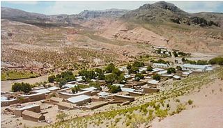
San Pablo de Lípez Municipality is the first municipal section of the Sur Lípez Province in the Potosí Department in Bolivia. Its seat is San Pablo de Lípez.
San Antonio de Esmoruco is the third municipal section of the Sur Lípez Province in the Potosí Department in Bolivia. Its seat is San Antonio de Esmoruco.

Kuntur Wasi is a 5,272-metre-high (17,297 ft) mountain in the Andes of Bolivia. It is situated in the Potosí Department, Sud Lípez Province, San Pablo de Lípez Municipality. Kuntur Wasi lies north of the Lluch'a Mayu (Llucha Mayu) east of San Pablo de Lípez.
Q'illu Salli is a 4,918-metre-high (16,135 ft) mountain in the Andes of Bolivia. It is situated in the Potosí Department, Sud Lípez Province, San Pablo de Lípez Municipality. Q'illu Salli lies south-east of San Pablo de Lípez, south-west of the mountain Kuntur Wasi and south of the river Lluch'a Mayu (Llucha Mayu).
Yuraq Urqu is a 4,504-metre-high (14,777 ft) mountain in the Andes of Bolivia. It is situated in the Potosí Department, Sud Lípez Province, San Pablo de Lípez Municipality, southwest of San Pablo de Lípez. Yuraq Urqu lies between the Qullpa Mayu in the north and the Yana Mayu in the south, north of Yana Urqu.
Yana Urqu is a 4,623-metre-high (15,167 ft) mountain in the Andes of Bolivia. It is located in the Potosí Department, Sud Lípez Province, San Pablo de Lípez Municipality, south-west of San Pablo de Lípez. Yana Urqu lies between the little rivers Yana Mayu in the north and Ñañu Mayu in the south. It is situated south of the peak of Yuraq Urqu.
P'aqu Urqu is a 5,182-metre-high (17,001 ft) mountain in the Andes of Bolivia. It is located in the Potosí Department, Sud Lípez Province, San Pablo de Lípez Municipality, southwest of San Pablo de Lípez. P'aqu Urqu lies between the mountains Yuraq Urqu and Yana Urqu in the northwest and Waqrayuq in the southeast.
Muruq'u is a 5,681-metre-high (18,638 ft) mountain in the Andes of Bolivia. It is situated in the Potosí Department, Sud Lípez Province, in the north of the Esmoruco Municipality, southwest of Guadalupe. Muruq'u lies southeast of P'aqu Urqu and Waqrayuq.
Nina Urqu is a 4,742-metre-high (15,558 ft) mountain in the Andes of Bolivia. It is situated in the Potosí Department, Sud Lípez Province, in the north of the Esmoruco Municipality, south-west of Guadalupe. Nina Urqu lies south-east of the mountains P'aqu Urqu, Waqrayuq and Muruq'u.
Ch'aska Urqu is a mountain in the Andes of Bolivia, about 4,640 metres (15,223 ft) high. It is situated in the Potosí Department, Sud Lípez Province, San Pablo de Lípez Municipality. Ch'aska Urqu lies west of the mountain Muruq'u and north-east of the mountains Palti Urqu and Q'illu Urqu.
Q'illu Urqu is a 4,526-metre-high (14,849 ft) mountain in the Andes of Bolivia. It is situated in the Potosí Department, Sud Lípez Province, San Pablo de Lípez Municipality. Q'illu Urqu lies south-west of the mountain Ch'aska Urqu and north-east of the mountain Palti Urqu. The river Qaqa Pallqa flows along its western slope.
Michina is a 5,537-metre-high (18,166 ft) mountain in the Cordillera Occidental in the Bolivian Andes. It is located in the Potosí Department, Sur Lípez Province, San Pablo de Lípez Municipality, at the border with Chile. Michina lies within the borders of the Eduardo Avaroa Andean Fauna National Reserve. It is situated south of Tocorpuri.
Suni K'ira is a 5,899-metre-high (19,354 ft) volcano in Bolivia. It is located in the Potosí Department, Nor Lípez Province, Colcha "K" Municipality, and in the Sud Lípez Province, San Pablo de Lípez Municipality. It lies north of the Uturunku volcano.
T'iyuyuq is a 5,015-metre-high (16,453 ft) mountain in Bolivia. It is located in the Potosí Department, Sud Lípez Province, San Pablo de Lípez Municipality. It lies southeast of Lípez and east of Suni K'ira.

Ch'iqlla is a 5,709-metre-high (18,730 ft) mountain in Bolivia. It is located in the Potosí Department, Sud Lípez Province, San Pablo de Lípez Municipality. Ch'iqlla lies between the Ch'iqu volcano in the north and Laguna Colorada in the south.
Luru Mayu is a 5,888-metre-high (19,318 ft) mountain in Bolivia. It is located in the Potosí Department, Sud Lípez Province, San Pablo de Lípez Municipality. It lies in the Eduardo Avaroa Andean Fauna National Reserve, southeast of a lake named Luru Mayu.

Sanawrya is a 5,654-metre-high (18,550 ft) mountain in Bolivia. It is located in the Potosí Department, Sud Lípez Province, San Pablo de Lípez Municipality. It lies in the Eduardo Avaroa Andean Fauna National Reserve, northeast of Laguna Colorada.


