
Randolph County is a county located in the U.S. state of West Virginia. As of the 2020 census, the population was 27,932. Its county seat is Elkins. The county was founded in 1787 and is named for Edmund Jennings Randolph.

Mingo County is a county in the U.S. state of West Virginia. As of the 2020 census, the population was 23,568. Its county seat and largest city is Williamson. Created in 1895, Mingo is West Virginia's newest county, named for the historic Iroquoian Mingo people.

Berkeley County is located in the Shenandoah Valley in the eastern panhandle region of West Virginia in the United States. The county is part of the Hagerstown–Martinsburg metropolitan area. As of the 2020 census, the county population was 122,076, making it the second-most populous of West Virginia's 55 counties, behind Kanawha County. The City of Martinsburg is the county seat.

Marmet is a town in Kanawha County, West Virginia, United States, along the Kanawha River. The population was 1,501 at the 2020 census.

Delbarton is a town in Mingo County, West Virginia, United States. The population was 522 at the 2020 census.
Kermit is a town in Mingo County, West Virginia, United States. The population was 406 at the 2010 census. Kermit is located along the Tug Fork, opposite Warfield, Kentucky. The Norfolk Southern Railway's Kenova District runs through town.
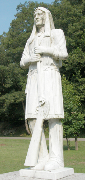
Logan the Orator was a Cayuga orator and war leader born of one of the Six Nations of the Haudenosaunee Confederacy. After his 1760s move to the Ohio Country, he became affiliated with the Mingo, a tribe formed from Seneca, Cayuga, Lenape and other remnant peoples. He took revenge for family members killed by Virginian long knives in 1774 in what is known as the Yellow Creek Massacre. His actions against settlers on the frontier helped spark Dunmore's War later that year.

The Guyandotte River is a tributary of the Ohio River, approximately 166 mi (267 km) long, in southwestern West Virginia in the United States. It was named after the French term for the Wendat Native Americans. It drains an area of the unglaciated Allegheny Plateau south of the Ohio between the watersheds of the Kanawha River to the northeast and Twelvepole Creek and the Big Sandy River to the southwest. Via the Ohio River, it is part of the Mississippi River watershed.
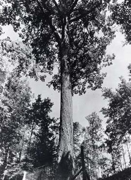
The Mingo Oak was a white oak in the U.S. state of West Virginia. First recognized for its age and size in 1931, the Mingo Oak was the oldest and largest living white oak tree in the world until its death in 1938.

The Battle of Blair Mountain was the largest labor uprising in United States history and is the largest armed uprising since the American Civil War. The conflict occurred in Logan County, West Virginia, as part of the Coal Wars, a series of early-20th-century labor disputes in Appalachia.
Daniel Greathouse (c.1752—1775) was a settler in colonial Virginia. His role in the Yellow Creek massacre in 1774 was instrumental in starting Lord Dunmore's War.

The West Virginia coal wars (1912–1921), also known as the mine wars, arose out of a dispute between coal companies and miners.
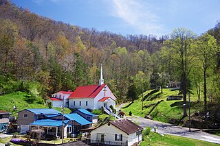
Mingo — sometimes known as Mingo Flats — is an unincorporated community in Randolph County, West Virginia, United States. It is located on U.S. Route 219, 15.5 miles (24.9 km) south-southwest of Huttonsville. It is named for the historic Iroquoian Mingo people.

This is a list of the National Register of Historic Places listings in Mingo County, West Virginia.
Myrtle is an unincorporated community in Mingo County, West Virginia, United States. Myrtle is located on U.S. Route 119 and the Trace Fork, 8 miles (13 km) northeast of Williamson. Myrtle had a post office, which opened on September 2, 1891, and closed on August 22, 1992.
The coal towns, or "coal camps" of Mingo County, West Virginia were situated to exploit the area's rich coal seams. Many of these towns were located in deep ravines that afforded direct access to the coal through the hillsides, allowing mined coal to be dropped or conveyed downhill to railway lines at the valley floor. Many of these encampments were set up as coal towns, and when their mines closed, the towns vanished. Mingo County covers the Williamson Coalfield and a small portion of the Logan Coalfield. Below is partial listing of known coal towns within the Williamson Coalfield and a small portion of the Logan Coalfield. Further listings are available here
Horsepen was an unincorporated community in Mingo County, West Virginia, United States. Their Post Office no longer exists.
Greyeagle is an unincorporated community in Mingo County, West Virginia, United States. Their post office no longer exists.
Cinderella is an unincorporated community and coal town in Mingo County, West Virginia, United States.


