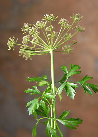
Parsley, or garden parsley is a species of flowering plant in the family Apiaceae that is native to Greece, Morocco and the former Yugoslavia. It has been introduced and naturalized in Europe and elsewhere in the world with suitable climates, and is widely cultivated as a herb, and a vegetable.
The following is a set–index article, providing a list of lists, for the cities, towns and villages within the jurisdictional United States. It is divided, alphabetically, according to the state, territory, or district name in which they are located.
Lea Ann Parsley is a retired American skeleton racer from Granville, Ohio. She was the first female skeleton athlete to win a world cup medal for the United States and earned a silver medal in the women's skeleton event, a first in Olympic history, during the 2002 Salt Lake City Olympic Winter Games. She was also one of eight athletes chosen to carry the World Trade Center flag into the Opening Ceremony of the 2002 Winter Olympics.

Quick is a small unincorporated community in Kanawha County, West Virginia, United States. It is located along Indian Creek Road. The community is where Whitoak Fork and Blue Creek come together and meet. It is also where the abandoned railroad that follows Blue Creek joins the road, and follows it all the way to the community of Hitop, along Pond Fork. Its post office is closed.
Belva is an unincorporated community and census-designated place in west Nicholas County and north Fayette County, West Virginia, United States; while the CDP only includes the Nicholas County portion, the Fayette County portion is considered part of the community. The town is situated at the bottomland surrounding the convergence of Bells Creek with Twentymile Creek and, subsequently, Twenty Mile Creek with the Gauley River. Belva is also the location of the convergence of two state highways: West Virginia Route 16 and West Virginia Route 39.
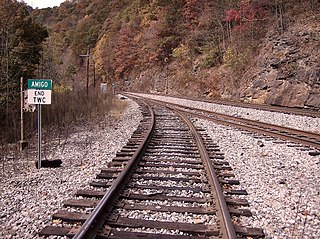
Amigo is an unincorporated community in Raleigh County, West Virginia, United States. The community is located on West Virginia Route 16 at the confluence of the Guyandotte River and Winding Gulf. The Amigo Post Office closed on October 22, 2011; it was established in 1915.

Pluto is an unincorporated community in Raleigh County, West Virginia. The elevation is 2,589 feet.
Surveyor is an unincorporated community in Raleigh County, West Virginia, United States. Surveyor is located on West Virginia Route 305, 7 miles (11 km) west of Beckley. Surveyor has a post office with ZIP code 25932.
Dickinson, also known as Quincy, is an unincorporated community in Kanawha County, West Virginia, United States. Dickinson is located on the north bank of the Kanawha River, 3 miles (4.8 km) southeast of Belle. The community is served by U.S. Route 60.
Corton is an unincorporated community in Kanawha County, West Virginia, United States. Corton is located on the Elk River and West Virginia Route 4, 4 miles (6.4 km) east of Clendenin.
Coco is an unincorporated community in Kanawha County, West Virginia, United States.
Beury is an unincorporated community and coal town in Fayette County, West Virginia, United States.
Parsley or garden parsley most often refers to the widely cultivated culinary herb Petroselinum crispum
Pursley is an unincorporated community in Tyler County, West Virginia, United States. Its post office is closed.
Crickmer is an unincorporated community in Fayette County, West Virginia, United States.
Lively is an unincorporated community in Fayette County, West Virginia, United States.
Weir is an unincorporated community in Kanawha County, West Virginia, United States. Its post office is called Falling Rock.
Legg is an unincorporated community in Kanawha County, West Virginia, United States. Its post office is closed.
Rensford is an unincorporated community in Kanawha County, West Virginia, United States. Its post office is closed. It was also known as Point Lick.
Bryce is an unincorporated community in Fayette County, West Virginia, United States.


