A ZIP Code is a postal code used by the United States Postal Service (USPS) in a system it introduced in 1963. The term ZIP is an acronym for Zone Improvement Plan; it was chosen to suggest that the mail travels more efficiently and quickly when senders use the code in the postal address. The basic format consists of five digits. An extended ZIP+4 code was introduced in 1983 which includes the five digits of the ZIP Code, followed by a hyphen and four additional digits that reference a more specific location.
POSTNET is a barcode symbology used by the United States Postal Service to assist in directing mail. The ZIP Code or ZIP+4 code is encoded in half- and full-height bars. Most often, the delivery point is added, usually being the last two digits of the address or PO box number.
ZIP Code Tabulation Areas (ZCTAs) are statistical entities developed by the United States Census Bureau for tabulating summary statistics. These were introduced with the Census 2000 and continued with the 2010 Census. This new entity was developed to overcome the difficulties in precisely defining the land area covered by each ZIP code. Defining the extent of an area is necessary in order to tabulate census data for that area.

Arcola is an unincorporated community in Upper Providence Township, Montgomery County, Pennsylvania, United States. Arcola is located on Perkiomen Creek 6.5 miles (10.5 km) west-northwest of Norristown. Arcola has a post office with ZIP code 19420, which opened on June 4, 1889.

Allaire is an unincorporated community located within Wall Township in Monmouth County, New Jersey, United States. As of the 2010 United States Census, the ZIP Code Tabulation Area for ZIP Code 07727 had a population of 7,050.
Cadogan is an unincorporated community in Cadogan Township, Armstrong County, Pennsylvania, United States. The community is located along the Allegheny River and Pennsylvania Route 128 5.3 miles (8.5 km) southwest of Kittanning. Cadogan has a post office with ZIP code 16212.
Nicktown is an unincorporated community in Cambria County, Pennsylvania, United States. The community is located at the junction of Pennsylvania Route 271 and Pennsylvania Route 553, 3.4 miles (5.5 km) south-southwest of Northern Cambria. Nicktown has a post office with ZIP code 15762, which opened on November 11, 1870.
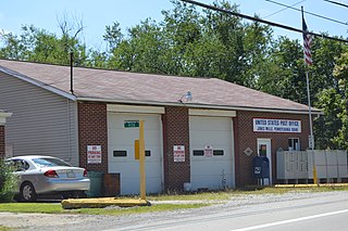
Claridge is an unincorporated community in Westmoreland County, Pennsylvania, United States. The community is 3.3 miles (5.3 km) northeast of Manor. Claridge has a post office with ZIP code 15623, which opened on January 25, 1886.
Jacobs Creek is an unincorporated community in Westmoreland County, Pennsylvania, United States. The community is located at the mouth of Jacobs Creek on the Youghiogheny River, 1.5 miles (2.4 km) south of Smithton. Jacobs Creek has a post office with ZIP code 15448, which opened on December 14, 1865.
Keisterville is an unincorporated community in Fayette County, Pennsylvania, United States. The community is located near Pennsylvania Route 43 5.5 miles (8.9 km) northwest of Uniontown. Keisterville has a post office with ZIP code 15449.
Leisenring is an unincorporated community in Fayette County, Pennsylvania, United States. The community is 3.2 miles (5.1 km) west-southwest of Connellsville. The Leisenring post office carries ZIP code 15455.
Merrittstown is an unincorporated community in Fayette County, Pennsylvania, United States. The community is located along Pennsylvania Route 166 3.5 miles (5.6 km) south of Brownsville. Merrittstown has a post office with ZIP code 15463.
Alverton is an unincorporated community in Westmoreland County, Pennsylvania, United States. The community is located along Pennsylvania Route 981 2.5 miles (4.0 km) west of Mount Pleasant. Alverton has a post office with ZIP code 15612.
Jones Mills is an unincorporated community in Westmoreland County, Pennsylvania, United States. The community is located along Pennsylvania Routes 31 and 381 2.8 miles (4.5 km) east-southeast of Donegal. Jones Mills has a post office with ZIP code 15646, which opened on May 23, 1850.
Wendel is an unincorporated community in Westmoreland County, Pennsylvania, United States. The community is 2.2 miles (3.5 km) south of Irwin. Wendel has a post office with ZIP code 15691, which opened on April 24, 1908.
Whitney is an unincorporated community in Westmoreland County, Pennsylvania, United States. The community is 5 miles (8.0 km) south-southwest of Latrobe. Whitney has a post office with ZIP code 15693.
Shawville is an unincorporated community in Clearfield County, Pennsylvania, United States. The community is located along the West Branch Susquehanna River at the intersection of Pennsylvania Route 879 and Pennsylvania Route 970, 5.1 miles (8.2 km) northeast of Clearfield. Shawville has a post office with ZIP code 16873.
Winburne is an unincorporated community in Clearfield County, Pennsylvania, United States. The community is 6.2 miles (10.0 km) northeast of Philipsburg. Winburne has a post office with ZIP code 16879.
Spring Glen is an unincorporated community in Schuylkill County, Pennsylvania, United States. The community is located along Pennsylvania Route 25 5.3 miles (8.5 km) east of Gratz. Spring Glen has a post office with ZIP code 17978, which opened on February 24, 1880.
Lehman is an unincorporated community in Lehman Township, Luzerne County, Pennsylvania, United States. The community is located along Pennsylvania Route 118 3.4 miles (5.5 km) west-southwest of Dallas. Lehman has a post office with ZIP code 18627, which opened on January 18, 1826.


