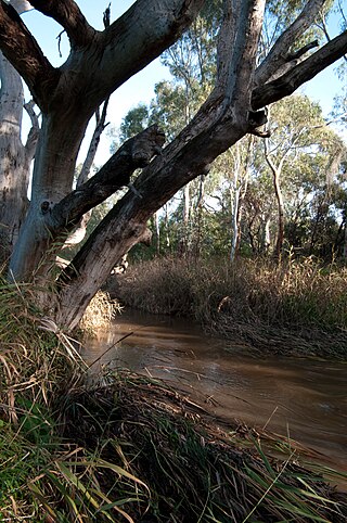
The Sturt River as it makes its way through Warriparinga.
Warriparinga, also spelt Warriparingga (meaning Windy Place in the local Kaurna language), is a nature reserve comprising 3.5 hectares (8.6 acres) in the metropolitan suburb of Bedford Park, in the southern suburbs of Adelaide, South Australia. Also known as Fairford, Laffer's Triangle, and the Sturt Triangle, Warriparinga is bordered by Marion Road, Sturt Road, and South Road, and is traversed by the Sturt River as it exists from Sturt Gorge to travel west across the Adelaide Plains.
It has historical, cultural and environmental significance as a traditional Kaurna ceremonial meeting place and as a site of early European settlement. Culturally, Warriparinga has particular significance to the Kaurna people through its association with the TjilbrukeDreaming story and as the beginning of the Tjilbruke Trail. An interpretive museum, the Living Kaurna Cultural Centre is located on the site and recognises this tradition. The area also has historical significance as an early European settlement site, as it was settled in the 1840s soon after the establishment of South Australia. A heritage-listed farmhouse remains on the site, having remained essentially unchanged after modifications were made in the 1920s, and the land contains grape vines and fruit trees planted by the early settlers.
In 1998 the site was redeveloped as a native wetland. Stocked with native vegetation and fish, the wetland was designed to filter water from the Sturt River before it reached the Patawalonga River.
Geography and location
Bounded by Sturt Road to the north, Marion Road to the west, and South Road to the south east, Warriparinga is part of a triangular section of land located in the southern Adelaide suburb of Bedford Park in the City of Marion. The site is traversed by the Sturt River which emerges from Sturt Gorge to enter Warriparinga as it starts to make its way along the Adelaide Plains, eventually joining the Patawalonga River. A portion of the Sturt River's flow is diverted on the site to form the Warriparinga Wetlands, while the river runs along a concrete drain once it leaves Warriparinga and continues in this vein until it joins the Patawalonga in Glenelg North.[1]
Pre-European settlement
A scarred tree at Warriparinga. Bark was removed to produce a shield or tray.
Prior to European settlement, Warriparinga played a significant role in the traditions of the local Kaurna people[1] – Warriparinga is the gateway to the TjilbrukeDreaming, which relates the story of how many of the springs south of Adelaide were formed.[2] Warriparinga was also a camping ground for the indigenous population, with kangaroos, emus and wallabies in the area, along with supplies of native food. Evidence of the traditional uses of the land includes a scarred tree, possibly used to make a shield or dish, and a number of scatter sites in the area where archaeologists have found aboriginal implements.[3]
Tjilbruke Dreaming
In the Dreaming, Tjilbruke's nephew, Kulultuwi, joined Tjilbruke and his half brothers, Jurawi and Tetjawi, on a hunt. Tjilbruke became separated from his nephews as he followed the tracks of an emu, returning to discover that Kulultuwi had killed the emu that Tjilbruke had been hunting. This was against local law, as the emu now belonged to Tjilbruke. Kulultuwi apologised, and, accepting his apology, Tjilbruke continued on his journey.[4]
With Tjilbruke gone, Kulultuwi was slain by his half brothers, on the grounds that Kulultuwi had broken the law by killing Tjilbruke's emu. They then bore his body to Warriparinga, where they intended to prepare it for burial. Tjilbruke came looking for Kulultuwi, and, determining that Kulultuwi had been murdered by his half brothers, killed Jurawi and Tetjawi at the site. Picking up his nephew's body, Tjilbruke carried him south to Patparno (Rapid Bay) for burial, resting at various locations along the path.[5] Where he rested his tears created freshwater springs, and, after Kulultuwi was buried, Tjilbruke's body turned to iron pyrite as his grief led him to choose to give up life as a man.[3] With the death of his body, his spirit transformed into a glossy ibis[6] – a motif that is featured in many aspects of Warriparinga today.
Post-European settlement
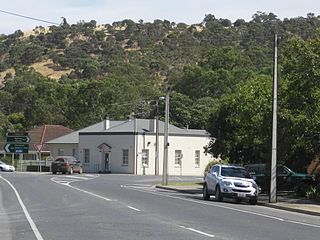
Fairford House at Warriparinga.
After the establishment of the City of Adelaide, the land was granted to George Fife Angas in 1839. Named after a local ford,[1] "Fairford" consisted of land and a single-roomed cottage. In 1843 George Angas leased the site to Henry William Trimmer. Trimmer worked the land for many years, eventually purchasing the site from the South Australian Company in 1862 for the sum of £1,118.[7]
Under Trimmer's custodianship, Fairford was developed to include over 13 acres (5.3 hectares) of vineyards – incorporating Gouais, Verdelho, Black Portugal and Grenache varieties – and various fruit trees. Henry Trimmer became a respected viticulturist, eventually taking on the role of Treasurer for the South Australian Vinegrowers' Association, although his "addiction to his own vintage" was to result in health problems later in life.[7] During this time the house was extended and a coach house was added to the property in the 1860s[1] – it is suggested by Dolling that these improvements may have been designed by colonial architect, (and Lord Mayor), Edmund Wright.[7]
Upon Trimmer's death in 1867, the property was passed to Trimmer's wife, Eliza Catherine Trimmer, and Edward Amand Wright, before being sold to Henry Laffer in 1876.[7] Henry Laffer continued farming the land, although his son, Albert, chose to focus more on fruit trees than vineyards and grazing.[3] The house was also modified during this period, with significant alterations occurring in the 1890s and again in 1923, at which point it took the form that it retains today – that of a 1920s bungalow.[8][9]
The Laffer family remained on the property for 112 years, earning it the new name of "Laffer's Triangle".[1]
Development
Over the years the property was considered for a number of projects, and parts of the land have been sold to various commercial and government interests. Warriparinga has been considered as the site for a number of major developments, such as the Marion Shopping Centre and Flinders Medical Centre – the latter moved because of concerns regarding a fault line that passes through the property, while the former was repositioned further west at the urging of both the investors and the Highways Department.[10] Projects that did go ahead included a holiday park, a (now defunct) restaurant, call centres, a science park as part of the failed Multifunction Polis project, and the Sturt police station.[8][11]
Three of the recent developments resulted in controversy. The first of these, the 1991 rebuilding of the South Road bridge over the Sturt River, led to the formation of the Friends of Laffer's Triangle when a local resident noticed the damage that the construction had caused to the local environment.[12] Environmental issues came to the fore during the planning of the Southern Expressway, along with concerns that the work would destroy a significant archaeological site at Warriparinga.[13] A similar combination of concerns resulted in changes to the Ansett Australia Call Centre after it was proposed in 2000, as both environmental and cultural issues led to a number of protests against its construction, although, like the other two projects, the call centre was eventually completed on the site.[14][15][16]
Renaming
Paul and Naomi Dixon started lobbying the Marion Council to protect the site in 1992, calling for the development of a "Warriparinga Interpretive Centre". Warriparinga, meaning "windy river place", was derived from a number of Kaurna names and variant spellings that have been recorded for the site, including Warri Parri, Warriparri, Warreparinga and Walpari.
As a result, in the early 1990s, the Friends of Laffer's Triangle changed their name to Friends of Warriparinga. As the plans developed the name started to be applied to the entire project and, over time, the site as a whole. Eventually the name was formally accepted for the Warriparinga Reserve and the Warriparinga Wetlands, and today the name has almost entirely replaced the earlier terms.[17]
Warriparinga Wetlands
One of the small ponds that make up part of the wetlands.
The Warriparinga Wetlands was a combined project by the Marion Council, the Patawalonga Catchment Water Management Board and the Land Management Corporation, who provided the land that was required.[18] Using a $1.7 million grant from the State Government, the wetlands were developed to filter water traveling along the Sturt River before it reached the Patawalonga.[19][20]
While the overall design was conducted by B C Tonkin and Associates,[21] the project involved a number of bodies, and, as no archaeological study had been previously undertaken on the site, one was organised. In addition, given the cultural significance of the site to the Kaurna people, representatives from the Kaurna Aboriginal Community and Heritage Association were included in the reference group.[18]
The final design consists of four ponds that are fed by water diverted from the Sturt River using a strategically placed fallen log. Native vegetation has been planted around the area, and incorporates native food sources and plants that were employed by the indigenous population for their fiber.[20] The ponds were stocked with a number of fish that were native to the area, including southern black bream (Acanthopagrus butcheri), bigheaded gudgeon (Philypnodon grandiceps), bridled goby (Arenigobius bifrenatus) and common galaxias (Galaxias maculatus).[19]
Work started on the new wetlands in June, 1998, and was completed by December of that year. The wetlands were officially opened by John Olsen, the then Premier of South Australia, on 16 December 1998.[20]
Awards
In 1999, a year after the wetlands were developed, the project was awarded a State CASE Earth Award. Created by the Civil Contractors Federation and Case Construction Equipment, the awards are intended to acknowledge environmental engineering within the civil engineering field.[22] A second award came in 2000 when the wetlands were granted a commendation in the South Australian Engineering Excellence Awards, at which the judges noted the attention that the developers had paid to the sensitive issues that were involved, given the mix of cultural, residential and business concerns, along with the engineering principles and practices that were employed at the site.[21]
Living Kaurna Cultural Centre
The entrance to the cultural centre.
First proposed in 1992 by Paul and Naomi Dixon, the Living Kaurna Cultural Centre (then known as the Warriparinga Interpretive Centre) was intended to educate visitors about the local Kaurna culture.[17][23] After several years of discussion, in 1998 the Marion Council received funding for the project through a federal grant of $1.45 million via the Federation Cultural and Heritage Program.[24]
Even with the funding now available, a number of setbacks occurred during development. Difficulties in finding compromise positions between stakeholders led the council to consider passing up the federal grant,[25] and while that problem was overcome, there were ongoing concerns about where to locate the project. The original intent had been to build the cultural centre on the opposite side of Sturt River to Fairford house, but infrastructure costs and changes to the design of the wetlands prevented this from going ahead.[9][26] Another site at Warriparinga was considered, but the construction of the Ansett Call Centre took precedence. The final location, next door to Fairford house, raised its own set of concerns, with suggestions that it would generate an architectural and cultural clash.[9][27] Nevertheless, the plan won the support of the council and Heritage SA, and proceeded accordingly.[27]
Work was completed on the Living Kaurna Cultural Centre by early September, 2002,[28] and it was officially opened later that month by representatives of the Kaurna people, the Marion Council Mayor, and local federal parliamentarian, Andrew Southcott.[29] The building was designed by Phillips/Pilkington Architects Pty Ltd and Habitable Places, and features a corrugated iron roof modeled to resemble the sweep of an ibis' wings, drawing a direction connection to the Tjilbruke Dreaming. The building incorporates an art gallery, a café, a retail area and a large stage, and the centre is used for education, cultural events, and retail sales of aboriginal and related produce.[23][28]
Art installations and cultural events
Tjilbruke narna arra, Tjilbruke Gateway by Sherry Rankine, Margaret Worth and Gavin Malone.
Located on the site is Tjilbruke narna arra, Tjilbruke Gateway, a representation of the Tjilbruke Dreaming by artists Sherry Rankine, Margaret Worth and Gavin Malone.[30] Commissioned by the City of Marion, the work consists of a number of tree trunks clustered together, interwoven with symbolic representations of aspects from the Dreaming. Amongst these symbols are a number of circles around selected trunks, representing the freshwater springs that were created by Tjilbruke's tears; flows of coloured sands running through the work to represent the gully winds and the "flow of the river and of life"; and a representation of an ibis positioned above iron pyrite, symbolising Tjilbruke's final transformation.[1][3] The work was intended, amongst other aims, to provide a space in which the Dreaming stories could be related by members of the Kaurna people.[30]
Warriparinga has been the site of a number of significant cultural events in recent years. These include the "friendship fires" initiated in 1999 by Georgina Williams, which were lit at each full moon. The events brought together up to 150 people, and were used by members of the Kaurna people to help maintain a connection to the land.[31] A similar fire was lit in May, 2004, and allowed to burn for several days as part of the National Reconciliation Week. The 2004 fire served as the centrepiece of a number of local celebrations and events during that period – including a farewell ceremony for outgoing Mayor, Colin Haines, and a protest against the building of the Ansett Call Centre close to the site.[32] Other Reconciliation Week events held at Warriparinga include the 2009 launch of the first new bark canoe since European settlement. Built by Paul Dixon, the canoe was carved using traditional techniques from a tree found in nearby Mitchell Park.[33]
The Kaurna people are a group of Aboriginal people whose traditional lands include the Adelaide Plains of South Australia. They were known as the Adelaide tribe by the early settlers. Kaurna culture and language were almost completely destroyed within a few decades of the British colonisation of South Australia in 1836. However, extensive documentation by early missionaries and other researchers has enabled a modern revival of both language and culture. The phrase Kaurna meyunna means "Kaurna people".
Victoria Square, also known as Tarntanyangga, is the central square of five public squares in the Adelaide city centre, South Australia.
The Port River is part of a tidal estuary located north of the Adelaide city centre in the Australian state of South Australia. It has been used as a shipping channel since the beginning of European settlement of South Australia in 1836, when Colonel Light selected the site to use as a port. Before colonisation, the Port River region and the estuary area were known as Yerta Bulti by the Kaurna people, and used extensively as a source of food and plant materials to fashion artefacts used in daily life.
Hallett Cove is a coastal suburb of Adelaide, South Australia located in the City of Marion 21 kilometres south of the Adelaide city centre. It has a population of more than 12,000 people. Adjoining suburbs are Marino to the north, Trott Park and Sheidow Park to the east and Lonsdale to the south.
O'Halloran Hill is a suburb in the south of Adelaide, South Australia, situated on the hills south of the O'Halloran Hill Escarpment, which rises from the Adelaide Plains and located 18 km from the city centre via the Main South Road. The suburb is split between the Cities of Marion and Onkaparinga, and it neighbours Happy Valley, Hallett Cove, Trott Park and Darlington. It includes a large area of former farmland and commercial vineyards known as the Glenthorne Estate, which in 2018 became the Glenthorne National Park–Ityamaiitpinna Yarta.
The Ramindjeri or Raminjeri people were an Aboriginal Australian people forming part of the Kukabrak grouping now otherwise known as the Ngarrindjeri people. They were the most westerly Ngarrindjeri, living in the area around Encounter Bay and Goolwa in southern South Australia, including Victor Harbor and Port Elliot. In modern native title actions a much more extensive territory has been claimed.
Kaurna is a Pama-Nyungan language historically spoken by the Kaurna peoples of the Adelaide Plains of South Australia. The Kaurna peoples are made up of various tribal clan groups, each with their own parnkarra district of land and local dialect. These dialects were historically spoken in the area bounded by Crystal Brook and Clare in the north, Cape Jervis in the south, and just over the Mount Lofty Ranges. Kaurna ceased to be spoken on an everyday basis in the 19th century and the last known native speaker, Ivaritji, died in 1929. Language revival efforts began in the 1980s, with the language now frequently used for ceremonial purposes, such as dual naming and welcome to country ceremonies.
Bedford Park is a southern suburb of Adelaide in South Australia.
Clovelly Park is an inner southern suburb of Adelaide in the local government area of the City of Marion. Before becoming an 'advanced' suburb, it was a farm and vineyard. The suburb is bordered by Daws Road to the north, South Road to the east, Sturt Road to the south, and a combination of Percy Avenue and the Flinders railway line to the west. It is situated approximately 20 minutes from the Adelaide city centre, and about 2 minutes from Flinders University, Flinders Medical Centre and Westfield Marion.
Port Noarlunga is a suburb in the City of Onkaparinga, South Australia. It is a small sea-side suburb, with a population of 2,918, about 30 kilometres to the south of the Adelaide city centre and was originally created as a sea port. This area is now popular as a holiday destination or for permanent residents wishing to commute to Adelaide or work locally. There is a jetty that connects to a 1.6 kilometres natural reef that is exposed at low tide.
Tjilbruke is an important creation ancestor for the Kaurna people of the Adelaide plains in the Australian state of South Australia. Tjilbruke was a Kaurna man, who appeared in Kaurna Dreaming dating back about 11,000 years. The Tjilbruke Dreaming Track or Tjilbruke Dreaming Trail is a major Dreaming trail, which connects sites from within metropolitan Adelaide southwards as far as Cape Jervis, some of which are Aboriginal sacred sites of great significance.
The District Council of Yankalilla is a local government area centred on the town of Yankalilla on the Fleurieu Peninsula in South Australia.
Burton is a small residential suburb approximately 21 kilometres north of the CBD of Adelaide, South Australia. It is located five km north-west of Salisbury in the flat terrain of the Adelaide Plains. The suburb contains two wetland reserves, including Kaurna Park.
Yankalilla is an agriculturally based town situated on the Fleurieu Peninsula in South Australia, located 72 km south of the state's capital of Adelaide. The town is nestled in the Bungala River valley, overlooked by the southern Mount Lofty Ranges and acts as a service centre for the surrounding agricultural district.
The Patawalonga River is a river located in the western suburbs of the Adelaide metropolitan area, in the Australian state of South Australia. It drains an area of flat, swampy lands formerly known as the Cowandilla Plains or The Reedbeds, which in the mid-20th century were drained by engineering works, enabling the establishment of Adelaide Airport and the development of residential housing.
The Sturt River, also known as the Sturt Creek and Warri Parri (Warriparri) in the Kaurna language, is a river located in the Adelaide region of the Australian state of South Australia.
Brukunga is a small town in the Adelaide Hills, located approximately 40 kilometres (25 mi) east of Adelaide and 4 kilometres (2.5 mi) north of the town of Nairne.
The Ingalalla Waterfalls, also known as Ingalalla Falls, is a cascade waterfall in the Australian state of South Australia, located in the locality of Hay Flat within the District Council of Yankalilla, on an unnamed creek on the Fleurieu Peninsula.
William Henry Trimmer was a vigneron and politician in the early colony of South Australia.
The Reedbeds was in the 19th and early 20th centuries the generally recognised name for an area of seasonal freshwater wetlands to the west of Adelaide, South Australia comprising the floodplains of the River Torrens, and drained to Gulf St Vincent by the tidal estuaries of the Port River and the Patawalonga River. The ephemeral wetland was known as Witongga tarto to the indigenous Kaurna people. The area was also formerly known as the Cowandilla Plains. The wetlands were inundated annually by the winter flows of the River Torrens, and supported an abundance of wildlife, a valuable source of food for the Kaurna people during their summer camps along the coastal barrier dunes.
References
Ahwan, Lauren (20 September 2000). "Diverse Reasons for Wetlands Award". The Guardian. Messenger Newspapers. p.7.
Ahwan, Lauren (5 September 2001). "Little Sign of Science". The Guardian. Messenger Newspapers. p.1.
Amery, Rob; Williams, Georgina Yambo (2002). "Reclaiming Through Renaming: The Reinstatement of Kaurna Toponyms in Adelaide and the Adelaide Plains". In Hercus, Luise; Hodges, Flavia; Simpson, Jane (eds.). The Land is a Map: placenames of indigenous origin in Australia(PDF). Pandanus Books. ISBN1-74076-020-4. Retrieved 28 July 2009.
"A step back in time at Warriparinga". The Guardian. Messenger Newspapers. 13 June 2001. p.3.
Barnes, Lainie (29 August 2000). "Start on $12m call centre after dispute". The Advertiser. p.12.
Brown, Rachel (11 September 2002). "Australian-First Reconciliation Symbol Finished". The Guardian. Messenger Newspapers. p.10.
"Call centre a threat to river: group". The Guardian. Messenger Newspapers. 4 October 2000. p.9.
Cowham, Scott (13 June 2001). "Marion's Cultural Clash". The Guardian. Messenger Newspapers. p.3.
Dolling, Alison (1981). The History of Marion on the Sturt. Peacock Publications. ISBN0-909209-48-0.
Donley, R.J.R. (2001). Marion 1945–2000: A Suburban City. Peacock Publications. ISBN1-876087-52-8.
Duffy, Michael (2 October 1999). "Aboriginal grant could be passed up". The Advertiser. p.40.
"Environment award for wetland project". The Advertiser. 19 June 1999. p.23.
Gall, Lucy (22 October 2003). "Friendship Fire Lights Way to River". Weekly Times. Messenger Newspapers. p.3.
Gould, Janet; Heylen, Margaret; Graham, Fred (2000). "Examples of Working Together in South Australia"(PDF). Local Government Association of SA and Government of South Australia. Retrieved 27 July 2009.
Hurt, Jessica (15 October 2002). "Sharing Kaurna heritage". The Advertiser. p.40.
Lloyd, Tim (16 June 2001). "Suburban Designs Place Historical Perspectives Under the Spotlight". The Advertiser. p.34.
Malone, Gavin (2007). "Ways of Belonging: Reconciliation and Adelaide's Public Space Indigenous Cultural Markers". Geographical Research. 45 (2): 158–166. doi:10.1111/j.1745-5871.2007.00445.x.
Morgan, Huw (17 December 1999). "New wetland to filter water to Patawalonga". The Advertiser. p.21.
Osborne, Emily (31 March 2001). "New home for cultural centre". The Advertiser. p.35.
"Reconciliation Burns Bright in Warriparinga". The Guardian. Messenger Newspapers. 24 May 2000. p.3.
This page is based on this Wikipedia article Text is available under the CC BY-SA 4.0 license; additional terms may apply. Images, videos and audio are available under their respective licenses.