The Tjilbruke Dreaming pre-dates European contact, probably arising when the "Adelaide plains tribe", the Kaurna, settled the area at least 2,000 years BP (as evidenced by archaeological finds at Hallett Cove, where Kaurna campsites succeeded those of the Kartan people of Kangaroo Island, who had been there tens of thousands of years earlier).[2]Kaurna Yerta Parngkarra (Kaurna tribal country) stretches from Cape Jervis in the south, to Crystal Brook in the north, west to the Mount Lofty Ranges, across to Gulf Saint Vincent, including the plains and city of Adelaide.[4][5]
The Tjilbruke story became part of the southern Kaurna Dreaming.[2] It is more than a creation story; it assumes the status of a religion for some, sets standards and rules for living, and provides spiritual meaning. It is both lore and law.[3] The lore tells of a time when all the people lived in accord with peaceful trading laws which governed all their lives. The law was brought to the land, and "Old Tjirbruki", who lived as an ordinary man, a keeper of the law which came from the south, after the water covered the land (when Wongga Yerlo, or Gulf St Vincent, was created.[4]). Tjilbruke was renowned as a "great hunter and firemaker", and a hero of the Kaurna. He also played a role in helping to protect the animals and the territory of the Kaurna, while at the same time having respect towards neighbouring peoples. It was part of his and Kaurna way of life to value all life, whether animal or human.[6]
Variant spellings and versions
In about 1840, anthropologist Ronald Berndt recorded the spellings "Tjirbuk" or "Tjirbuki" from Ngarrindjeri man Albert Karlowan, as the name of a small wetland.[7] Anthropologist Norman Tindale of the South Australian Museum recorded the spelling as Tjirbruki, but Tjilbruke is the commonly used spelling today.[4]
Since the early 1980s the Williams family, of the Mullawirra and Mulla mai/Kudnarto clans, have been senior custodians of the Tjilbruke story, and Karl Winda Telfer has collaborated with Gavin Malone to share the story. Milerum, also known as Clarence Long, has also been a contributor. The Tjilbruke story is part of a bigger and more complex story known as the Munaintya Dreaming, that has been passed down through oral tradition through the years.[4]
Tjilbruke Dreaming story
The tale of Tjilbruke's journey down the east coast of Wongga Erlo/Gulf St Vincent is the best known of all Kaurna Dreaming stories, and has become a symbol of renewal of the Kaurna culture, although it was first recorded from Ngarrindjeri sources by Tindale and later Ronald and Catherine Berndt. It was recorded by Tindale over a period of many years up to 1964, but it was not until 1987 that he published the most complete version hitherto published, as The Wanderings of Tjirbruki: a tale of the Kaurna People of Adelaide.[8]
The story starts with an emu (kari) hunt by three men, Kulultuwi, Jurawi and Tetjawi. They were all nephews of Tjilbruke, but Kulultuwi had a special relationship to his uncle, as he was the son of his sister, and known as his nangari; the other two were his half-brothers.[4] Tjilbruke was responsible for Kulutwi, as an uncle as well as a father, to help him grow up correctly and do the right thing.[6] While the young men went hunting in the Tarndanya (Adelaide) area, across Mikkawomma (the plains) to Yerta Bulti (Port River estuary), driving the birds up Mudlangga (Le Fevre Peninsula), Tjilrbuke went fishing at Witu-wattingga (the Brighton area). After finishing his fishing, he set up camp at Tulukudangga/Tulukudank (Kingston Park and then started tracking an emu southwards. When Kulultuwi returned to the area, he found himself tracking the same emu as his uncle, which he was forbidden to do. However he killed the emu, and Tjilbruke, although initially angry, forgave him when he gave him some of the emu meat.[4] (In one version of the story, although Kulultuwi was not supposed to have killed the kari ahead of his uncle, Tjilbruke gave him permission to do so, as long as he gave him some of the meat.[9])
While Kulultuwi was cooking the emu meat over a fire, Jurawi and Tetjawi killed him with their spears, as punishment for his breaking the law of the clan. The brothers took the body to their clan campsite at Warriparri (Sturt River) and told them the story, and they started to dry the body with smoke, as custom dictated. After Tjilbruke found out, he was very upset, and speared the two nephews to death (in retaliation, applying the law, being a man of the law[9]), before carrying Kulultuwi's body to Tulukudangga, where an inquest and ceremony to complete the smoking of the body was held.[4]
After Kulultuwi's body had been smoked and dried,[9] Tjilbruke picked up the body and carried it firstly to Tulukudangga/Tulukudank. Here some versions of the story diverge slightly; one says that he wept at this point and his tears created this spring,[6] while another says that Tulukudangga was an existing spring at that place.[8] From Tulukudangga, Tjilbruke carried Kulultuwi's body all the way down the eastern side of Gulf St Vincent and onto and down the west coast of the Fleurieu Peninsula.[6] At sunset every night of his journey Tjilbruke cried over his nephew's body, and his tears transformed into freshwater springs at six locations:[1]
He arrived at a cave (perki[9]) at Rapid Bay, near Cape Jervis,[6] and then emerged from underground at Wateira nengal (Mount Hayfield) and created yellow ochre. He walked on to Lonkowar (The Bluff/Rosetta Head, in Ramindjeri country[4]), near Victor Harbor,[8] where he killed a grey currawong, rubbed its fat onto his body and tied its feathers onto his arms,[4] before transforming himself into a glossy ibis (or other wading bird;[6] in some sources, a blue crane[3]) as his spirit left his body. His body became the pyrite outcrop at Brukunga.[8]
Saddened by these events Tjilbruke decided he no longer wished to live as a man. His spirit became a bird, the Tjilbruke (Glossy Ibis), and his body became a martowalan (memorial) in the form of the baruke (iron pyrites) outcrop at Barrukungga, the place of hidden fire (Brukunga - north of Nairne in the Adelaide Hills). Tjilbruke was a master at fire-making.[8][9]
Creation of the Tjilbruke Dreaming Track (1986–2006)
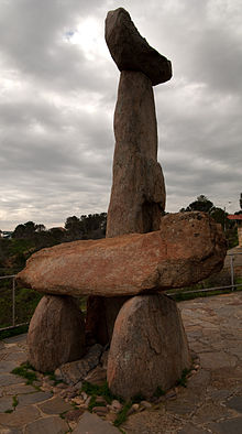
The Tjilbruke Monuments Committee was formed by Robert Edwards of the South Australian Museum (SAM), sculptor John Dowie and staff of the Sunday Mail in 1971. It was largely due to the efforts of Edwards and other non-Aboriginal people that drove the early promotion of Kaurna cultural tourism. A public appeal helped to fund the marking of the trail by plaques and sculptures, to pay homage to the Kaurna culture and to attract and educate tourists. In 1972 John Dowie created the sculpture known as the Tjilbruke Monument at Kingston Park, within the City of Holdfast Bay.[3][8]
Cairns were created at significant points along the Tjilbruke Trail articles and booklets were published in the 1980s, and the trail was included in Aboriginal Studies curricula. However, there was little input from Kaurna people at this stage.[3]
In 1981, Georgina Williams[Note 1] (SAM) began to research the trail. It was important to her "because Tjilbruke was to me an example of the law of my people and of the law related to the land and the places along the coast". A number of the sites have special spiritual significance, and in the 1980s, work by the successor to the Tjilbruke Monuments Committee, the Tjilbruke Track Committee, on the track became a central focus of Kaurna identity. The Committee was later renamed the Kaurna Heritage Committee and then grew into the Kaurna Aboriginal Community and Heritage Association (KACHA) in the 1990s, which became recognised as the representative body for all Kaurna people on cultural heritage and other matters.[3]
The Tjilbruke Dreaming Track, or Tjilbruke Dreaming Trail, marked by commemorative plaques at ten locations, was created during the 150th anniversary of British colonisation of South Australia (1986), along the coast in close proximity to the sea shore. Various events, mostly celebrating white history, were held throughout the year, with the final celebrations on December 28, 1986, 150th anniversary of the Proclamation of South Australia. However the Dreaming Track was one of about 30 Aboriginal projects which were considered, and was a major undertaking. While the original idea had been to erect a monument at Rosetta Head/The Bluff at Victor Harbor, the site where Tjilbruke’s spirit left earth and turned into the ibis, Georgina Williams pushed for the idea of the track, with several sites down the coast marked, "to provide a contemporary Kaurna presence within the physical public space of their own lands and in the public imagination".[8]
In 2005, the City of Marion partnered with the City of Holdfast Bay, City of Onkaparinga and Yankalilla District Council to develop the Kaurna Tappa Iri Regional Agreement 2005-2008 (Walking Together), in which the Tjilbruki Dreaming Trail featured significantly. In 2006, six Kaurna interpretive signs were installed along the trail, in a collaboration with the state government.[10] The markers have immense cultural and social significance for both Aboriginal and non-Aboriginal people, and help to bring Aboriginal cultural meaning to a wider audience.[8]
Heading south from the Tjilbruke Monument at Kingston Park, there are ten markers, located at the following places:[8]
8 Wirrina Cove Resort/Kongaratinga, entrance forecourt – site of the sixth spring
9 Rapid Bay/Patpangga, foreshore
10 Cape Jervis/Parawerangk, lookout car park
In 2009, a walkway was created to provide better access to Tulukudangga Spring at Kingston Park, with new interpretative signage.[8]
In the current City of Marion Reconciliation Plan, it is planned to "Collaborate with neighbouring Councils to promote the local Kaurna Tjilbruke Dreaming Tracks" in June 2022.[10]
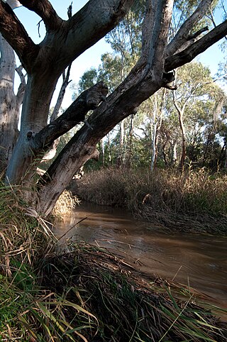
A federal government-funded reconciliation project in partnership with the City of Marion and the Kaurna community (Dixon and Williams clans) worked together to create a visitor and education centre for Indigenous and non-Indigenous people to come together and reconcile their differences in the now metropolitan suburb of Marion, South Australia at a site known as site at Warriparinga.[12] This site at Bedford Park within the grounds of Warriparinga wetland and Sturt River, a traditional ceremonial camp site for Kaurna people.[13] Opened in 2001,[10] it was named the Warriparinga Interpretive Centre, subsequently becoming the Living Kaurna Cultural Centre.[14]
There is a plaque at Mt Lofty Summit with information about Tjilbruke.[3]
Designed by Kokatha[17][18] artist Darryl Pfitzner "Mo" Milika, the outdoor art installationYerrakartarta, meaning "at random" or "without design", was created with the assistance of several other artists including Kaurna/Ngarrindjeri artist Muriel van der BylAM,[Note 2] ceramicists Jo Fraser, Stephen Bowers, and Jo Crawford from 1993 to 1994 on the forecourt of the Hyatt, now Intercontinental Hotel, on North Terrace in Adelaide. It was at the time "the largest Australian commission for an Aboriginal public artwork",[20][21] and represents the history of the land through the forms of animals forms cut into the pavement, and, on the wall surrounding the area, a huge ceramic mural depicting the Tjillbruke Dreaming story.[17][21]
2006: Warriparinga Walk Mural, under the Southern Expressway bridge at Warriparinga, Bedford Park
2002: Kaurna meyunna, Kaurna yerta tampendi – "Recognising Kaurna people and Kaurna land", Adelaide Festival Centre, with a carved stone to represent the springs
2007: Towilla Yerta Reserve, Port Willunga – pavement pattern includes a tear shape, and there is interpretive signage referring to the Dreaming
2009: Glow / Taltaityai, Walter Morris Drive, Port Adelaide, with representations of ibis and emus
Footnotes
↑ Williams is one of a number of Kaurna people, including Lewis O'Brien, Gladys Elphick, and Alice Rigney, who "are the driving force behind a cultural revival" and were responsible for introducing Kaura perspectives into the SA education curriculum.[3]
The Kaurna people are a group of Aboriginal people whose traditional lands include the Adelaide Plains of South Australia. They were known as the Adelaide tribe by the early settlers. Kaurna culture and language were almost completely destroyed within a few decades of the British colonisation of South Australia in 1836. However, extensive documentation by early missionaries and other researchers has enabled a modern revival of both language and culture. The phrase Kaurna meyunna means "Kaurna people".
Victoria Square, also known as Tarntanyangga, is the central square of five public squares in the Adelaide city centre, South Australia.
The Port River is part of a tidal estuary located north of the Adelaide city centre in the Australian state of South Australia. It has been used as a shipping channel since the beginning of European settlement of South Australia in 1836, when Colonel Light selected the site to use as a port. Before colonisation, the Port River region and the estuary area were known as Yerta Bulti by the Kaurna people, and used extensively as a source of food and plant materials to fashion artefacts used in daily life.
Hallett Cove is a coastal suburb of Adelaide, South Australia located in the City of Marion 21 kilometres south of the Adelaide city centre. It has a population of more than 12,000 people. Adjoining suburbs are Marino to the north, Trott Park and Sheidow Park to the east and Lonsdale to the south.
O'Halloran Hill is a suburb in the south of Adelaide, South Australia, situated on the hills south of the O'Halloran Hill Escarpment, which rises from the Adelaide Plains and located 18 km from the city centre via the Main South Road. The suburb is split between the Cities of Marion and Onkaparinga, and it neighbours Happy Valley, Hallett Cove, Trott Park and Darlington. It includes a large area of farmland and commercial vineyards known as the Glenthorne Estate.
Marino is a coastal suburb in the south of Adelaide, South Australia that's surrounded by a conservation park and rugged coastline. This suburb is a brilliant place for families to develop an adventurous life in a unique setting with most houses having sea views and access to meandering public open spaces. The suburb even has its own working lighthouse. Marino's elevated position provides panoramic views of the ocean – Gulf St Vincent, the metropolitan beaches and Adelaide CBD. Marino has access to the North or South via Brighton Road, has two railway stations on the main Seaford Line and a host of walking and cycle trails to the neighbouring beaches and wine region. A community cooperative has purchased a restaurant building on the beachfront on Marine Parade. It's called Marino Rocks Social. The cooperative's first project is to run a cafe. The cooperative has 250 members, all with equal status, who have invested money or effort and is completely independent of other local community associations.
Kaurna is a Pama-Nyungan language historically spoken by the Kaurna peoples of the Adelaide Plains of South Australia. The Kaurna peoples are made up of various tribal clan groups, each with their own parnkarra district of land and local dialect. These dialects were historically spoken in the area bounded by Crystal Brook and Clare in the north, Cape Jervis in the south, and just over the Mount Lofty Ranges. Kaurna ceased to be spoken on an everyday basis in the 19th century and the last known native speaker, Ivaritji, died in 1929. Language revival efforts began in the 1980s, with the language now frequently used for ceremonial purposes, such as dual naming and welcome to country ceremonies.
Seacliff Park is a suburb of Adelaide partly in the City of Marion and the City of Holdfast Bay. The suburb is adjacent to South Brighton in the north, Seaview Downs to the east, Hallett Cove to the south, and Marino and Seacliff on its western side. The suburb is divided diagonally by Ocean Road, with the northern part of the suburb mainly residential, and the southern park partly occupied by a golf course and a quarry.
Port Noarlunga is a suburb in the City of Onkaparinga, South Australia. It is a small sea-side suburb, with a population of 2,918, about 30 kilometres to the south of the Adelaide city centre and was originally created as a sea port. This area is now popular as a holiday destination or for permanent residents wishing to commute to Adelaide or work locally. There is a jetty that connects to a 1.6 kilometres long natural reef that is exposed at low tide. The beach is large and very long and has reasonable surfing in the South Port area whose name is taken from its location - "South of the Port".
Warriparinga, also spelt Warriparingga, is a nature reserve comprising 3.5 hectares in the metropolitan suburb of Bedford Park, in the southern suburbs of Adelaide, South Australia. Also known as Fairford, Laffer's Triangle and the Sturt Triangle, Warriparinga is bordered by Marion Road, Sturt Road and South Road, and is traversed by the Sturt River as it exists from Sturt Gorge to travel west across the Adelaide Plains.
The District Council of Yankalilla is a local government area centred on the town of Yankalilla on the Fleurieu Peninsula in South Australia.
Carrickalinga is a small coastal town in South Australia about 60 kilometres (37 mi) south of Adelaide on the Fleurieu Peninsula overlooking Gulf St Vincent. The town has no shops, with the nearest being in Normanville, one kilometre away. Haycock Point separates two beaches, sometimes referred to as North Carrickalinga and South Carrickalinga beaches, both on Yankalilla Bay. Carrickalinga Creek discharges into the sea south of the town.
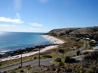
Sellicks Beach, formerly spelt Sellick's Beach, is a suburb in the Australian state of South Australia located within Adelaide metropolitan area about 47 kilometres (29 mi) from the Adelaide city centre. It is an outer southern suburb of Adelaide and is located in the local government area of the City of Onkaparinga at the southern boundary of the metropolitan area. It is known as Witawali or Witawodli by the traditional owners, the Kaurna people, and is of significance as being the site of a freshwater spring said to be created by the tears of Tjilbruke, the creator being.
Moana is an outer coastal suburb in the south of Adelaide, South Australia. The suburb is approximately 36.4 km from the Adelaide city centre. It lies within the City of Onkaparinga local government area, and neighbours the suburbs Seaford, Maslin Beach, Seaford Rise and Port Noarlunga It is divided into two by Pedler Creek and the associated sand dune reserve. The beach is often referred to as Moana Beach.
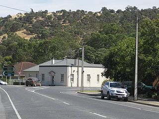
Yankalilla is an agriculturally based town situated on the Fleurieu Peninsula in South Australia, located 72 km south of the state's capital of Adelaide. The town is nestled in the Bungala River valley, overlooked by the southern Mount Lofty Ranges and acts as a service centre for the surrounding agricultural district.
Kingston Park is a small beachside suburb, 17 kilometres (11 mi) south of the Adelaide city centre. Kingston Park is within the City of Holdfast Bay and flanked by the neighbouring suburbs of Marino to the south and Seacliff to the north and east.
Hallett Cove Conservation Park is a protected area in the Australian state of South Australia located in the suburb of Hallett Cove on the coast of Gulf St Vincent about 22 kilometres south of the centre of the state capital of Adelaide.
Port Willunga is a semi-rural suburb of Adelaide, South Australia. It is known as Wirruwarrungga or Ruwarunga by the traditional owners, the Kaurna people, and is of significance as being the site of a freshwater spring said to be created by the tears of Tjilbruke, the creator being.
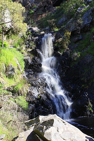
The Ingalalla Waterfalls, also known as Ingalalla Falls, is a cascade waterfall in the Australian state of South Australia, located in the locality of Hay Flat within the District Council of Yankalilla, on an unnamed creek on the Fleurieu Peninsula.
Wirrina Cove is a locality and holiday resort on the Fleurieu Peninsula, South Australia. It is located between the coastal towns of Second Valley and Normanville on Yankalilla Bay. The holiday resort was developed from around 1972, and is located about 90 kilometres (56 mi) south of Adelaide.
↑ City of Onkaparinga (July 2017). Annual Report 2016-17 (Report). In December the stone cairn that marks the Tjirbruki/Tjilbruke Dreaming Track natural spring at Port Noarlunga was reinstated in the reserve atop Witton Bluff. This reserve has since been named Tutu Wirra Reserve, meaning 'lookout park' in the Kaurna language. The new location for the cairn was selected through engagement with a local Kaurna elder. The cairn at Port Noarlunga is one of four Tjirbruki/Tjilbruke markers along the coastline in our region.
1 2 "Yerrakartarta". The Rambling Wombat. 4 October 2017. Retrieved 21 November 2020.
↑ Milika, Darryl Pfitzner. "Introduction". Aboriginal Art & Amateur Astronomy: A Confluence of Culture, Creativity, Art & Science. Retrieved 21 November 2020.
1 2 Milika, Darryl Pfitzner. "Art Gallery". Aboriginal Art & Amateur Astronomy: A Confluence of Culture, Creativity, Art & Science. Retrieved 21 November 2020.
External links
Nganu and Tjilbruke: a tale of two heroes on YouTube (April 2020, video, 10 mins) "This short story is used with permission from the Monash University through partnership between Kaurna Warra Karrpanthi Aboriginal Corporation and South Australian Commission for Catholic Schools, in consultation with Kaurna Elder Uncle Lewis O’Brien."
This page is based on this Wikipedia article Text is available under the CC BY-SA 4.0 license; additional terms may apply. Images, videos and audio are available under their respective licenses.