
Protected areas of South Australia consists of protected areas located within South Australia and its immediate onshore waters and which are managed by South Australian Government agencies. As of March 2018, South Australia contains 359 separate protected areas declared under the National Parks and Wildlife Act 1972, the Crown Land Management Act 2009 and the Wilderness Protection Act 1992 which have a total land area of 211,387.48 km2 (81,617.16 sq mi) or 21.5% of the state's area.

The Ikara-Flinders Ranges National Park is situated approximately 400 km north of Adelaide in the northern central part of South Australia's largest mountain range, the Flinders Ranges. The park covers an area of 912 km², northeast of the small town of Hawker. The Heysen Trail and Mawson Trails pass through the park.

Mount Wellington, officially kunanyi / Mount Wellington, incorporating its Palawa kani name, is a mountain in the southeast coastal region of Tasmania, Australia. It is the summit of the Wellington Range and is within the Wellington Park reserve. Located at the foothills of the mountain is much of Tasmania's capital city, Hobart.

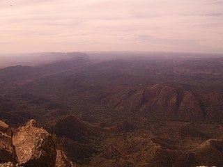
The Flinders Ranges are the largest mountain range in South Australia, which starts about 200 km (125 mi) north of Adelaide. The discontinuous ranges stretch for over 430 km (265 mi) from Port Pirie to Lake Callabonna. The Adnyamathanha people are the Aboriginal group who have inhabited the range for tens of thousands of years.

The Vulkathunha-Gammon Ranges National Park is a protected area in the Australian state of South Australia located in the northern Flinders Ranges, immediately southwest of and adjacent to the Arkaroola Protection Area. They encompass some of the most rugged and spectacular country in South Australia.

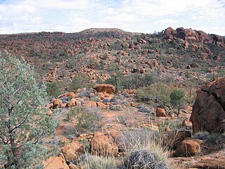
Arkaroola is the common name for the Arkaroola Wilderness Sanctuary, a wildlife sanctuary situated on 610 square kilometres of freehold and pastoral lease land in South Australia. It is located 700 kilometres north of the Adelaide city centre in the Northern Flinders Ranges, adjacent to the Vulkathunha-Gammon Ranges National Park and the Mawson Plateau. The most common way to get there is by car, but air travel can be chartered from Parafield Airport, Adelaide Airport or Aldinga Airfield. It was used as a location set for the 2002 film The Tracker.

The Mount Lofty Ranges are the range of mountains just to the east of Adelaide in the Australian state of South Australia.
Wilpena Pound – also known by its Adnyamathanha name of Ikara, meaning "meeting place" – is a natural amphitheatre of mountains located 429 kilometres (267 mi) north of Adelaide, South Australia, Australia in the heart of the Ikara-Flinders Ranges National Park. It is accessible via a sealed road which continues on to the northern Flinders Ranges town of Blinman and to the south, Hawker.

Lake Frome is a large endorheic lake in the Australian state of South Australia located to the east of the Northern Flinders Ranges. It is a large, shallow, unvegetated salt pan, 100 kilometres (62 mi) long and 40 kilometres (25 mi) wide, lying mostly below sea level and having a total surface area of 259,615 hectares. It only rarely fills with brackish water flowing down usually dry creeks in the Northern Flinders Ranges from the west, or exceptional flows down the Strzelecki Creek from the north.

The yellow-footed rock-wallaby, formerly known as the ring-tailed rock-wallaby, is a member of the macropod family.
Reginald Claude Sprigg, was an Australian geologist and conservationist. At 17 he became the youngest Fellow of the Royal Society of South Australia. During 1946, in the Ediacara Hills, South Australia he discovered the Ediacara biota, an assemblage of some of the most ancient animal fossils known. He was involved with oceanographic research and petroleum exploration by various companies that he initiated. In 1968, he acquired a derelict pastoral lease, Arkaroola, and transformed it into a wildlife sanctuary and wilderness reserve.
The Mawson Plateau30°6′38″S139°25′19″E is part of the northern Flinders Ranges, located on the Mount Freeling pastoral lease in South Australia, 140 km east of Lyndhurst and adjacent to the northeastern boundary of Arkaroola.

Yudnamutana is an historic mining valley in the Northern Flinders Ranges, located at Mount Freeling, North West of Arkaroola on the edge of the wilderness sanctuary. It is accessible by four-wheel drive from the south. Ancient mining sites give the opportunity for ecologically responsible bush camping, but no supplies are available. Walks across the crests of the mountains deliver splendid views over the Flinders Ranges into the plains of the outback. The northern pass hosts black rocks of magnetite.

Mount Gee is located in the northern Flinders Ranges within the Arkaroola Wilderness Sanctuary, and is part of the Mount Painter inlier. It was named after a mining warden, Lionel Gee.

The Beverley Mine is Australia's third uranium mine and Australia's first operating in-situ recovery mine. It is located in South Australia in the gazetted locality of Wooltana about 35 km from Lake Frome at the northern end of the Flinders Ranges.It officially opened in 2001. The original Beverley uranium deposit was discovered by one of Bill Siller's companies in 1969 and was named after his wife—Beverley Siller.

The Flinders Peak Group is an unnamed range of hills located on the northern edge of the Scenic Rim Region, south west of Logan City and south east of the City of Ipswich in South East Queensland, Australia. The summit in the Range is Flinders Peak reaching 680 metres (2,230 ft) above sea level.
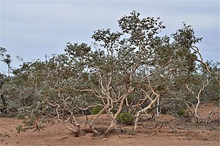
Eucalyptus gillii, known as the curly mallee, Arkaroola mallee, or silver mallee, is a species of mallee or small tree that is endemic to inland Australia. It has smooth bark, sometimes with rough bark near the base, often only juvenile, usually glaucous leaves in the crown, flower buds in groups of between seven and eleven, pale yellow flowers and barrel-shaped or shortened spherical fruit.
Spriggite is an uranyl hydroxide mineral with chemical formula Pb3(UO2)6O8(OH)2·3H2O. Its type locality is Mt Painter region, Arkaroola region, Flinders Ranges, South Australia. It was named after Reginald C. Sprigg (1919–1994).
Arkaroola Protection Area is a protected area located about 600 km (370 mi) north of the Adelaide city centre in the Australian state of South Australia. It was established in 2012 by the Arkaroola Protection Act 2012 "to provide for the proper management and care of the area; and to prohibit mining activities in the area". The protection area is reported as satisfying the definition of a "category II National Park".
Warratyi is the site of a prehistoric rock shelter in the Flinders Ranges in South Australia. Located around 550 kilometres (340 mi) north of Adelaide and about 200 kilometres (120 mi) inland, it has been identified as the oldest known site of human habitation in inland Australia. Newspapers reported that this rock shelter was discovered by chance in 2011 by a local resident who stumbled upon it while looking for somewhere to go to the toilet. Researchers found thousands of artefacts and bone fragments, which enabled them to date the shelter's occupation to a number of periods between 49,000 and 10,000 years ago. The finds include the earliest evidence in Australia of the development of bone and stone-axe technology, the use of ochre, and interaction with megafauna such as Diprotodon.