Washington State Route 519

Last updated • 4 min readFrom Wikipedia, The Free Encyclopedia

WA-519.svg

State Route 519

Washington State Route 519
SR 519 highlighted in red
Route information
Auxiliary route of I-5
Maintained by WSDOT
Length1.09 mi [1]  (1.75 km)
Existed1991 [2] –present
Major junctions
South endI-90.svg I-90 in Seattle
Major intersectionsWA-99.svg SR 99 in Seattle
North endFerry Sign.svg Colman Dock in Seattle
Location
Country United States
State Washington
County King
Highway system
WA-518.svg SR 518 WA-520.svg SR 520

State Route 519 (SR 519) is a state highway in Seattle, Washington, United States. It connects Interstate 90 (I-90) to the Port of Seattle and Colman Dock, which serves as the terminus of two ferry routes. The highway travels along city streets, including two named for Seattle Mariners personalities: Edgar Martinez Drive and Dave Niehaus Way, as well as Alaskan Way. SR 519 was established in 1991 on preexisting streets that were first built in the early 20th century. State projects moved the southern terminus of SR 519 in 2010 to its current location and temporarily rerouted it during demolition of the Alaskan Way Viaduct.

Contents

Route description

The northern terminus of SR 519 at Colman Dock (Pier 52) on the Central Waterfront of Seattle viewed from the Columbia Center Colman Dock (Pier 52) from Columbia Center.jpg
The northern terminus of SR 519 at Colman Dock (Pier 52) on the Central Waterfront of Seattle viewed from the Columbia Center

SR 519 begins as Edgar Martinez Drive, named for former Seattle Mariners player Edgar Martínez, [3] in the SoDo neighborhood south of Downtown Seattle. The highway begins at an elevated intersection with 4th Avenue and the western terminus of I-90. [4] The highway travels west over BNSF Railway tracks, heading north to King Street Station, [5] and turns north onto Dave Niehaus Way, named for former Mariners sportscaster Dave Niehaus, [6] at an intersection with South Atlantic Street. Dave Niehaus Way continues north along the west side of T-Mobile Park and Lumen Field before becoming 1st Avenue. SR 519 turns west onto South Dearborn Street and north onto Alaskan Way at an intersection with ramps serving SR 99 at the south portal of its downtown tunnel. The highway ends at an intersection with Yesler Way at Colman Dock (Pier 52), [1] which is served by two state ferry routes to Bremerton and Bainbridge Island. [7] Alaskan Way continues north along the city's waterfront towards Lower Queen Anne. [8]

The highway primarily serves as a connector to Colman Dock, the Port of Seattle, and the city's waterfront. [7] Every year, the Washington State Department of Transportation (WSDOT) conducts a series of surveys on its highways in the state to measure traffic volume. This is expressed in terms of annual average daily traffic (AADT), which is a measure of traffic volume for any average day of the year. Average traffic volumes on the highway in 2019 ranged from a minimum of 12,000 vehicles on Alaskan Way near Colman Dock to a maximum of 33,000 vehicles on 1st Avenue near T-Mobile Park. [9] The state government has designated SR 519 as a Highway of Statewide Significance, which includes principal arterials that are needed to connect major communities in the state. [10]

History

SR 519 northbound on Alaskan Way after the demolition of the viaduct State Route 519 (Alaskan Way) northbound from South King Street.jpg
SR 519 northbound on Alaskan Way after the demolition of the viaduct

SR 519 was codified in 1991 as a state highway and began at the western terminus of I-90, then at 4th Avenue S., and traveled west onto Royal Brougham Way and north on Alaskan Way to Colman Dock. [2] The city streets in Seattle used by SR 519 were constructed after the series of regrades in the early 20th century filled a mudflat in SoDo. [11] By 1916, Alaskan Way (then known as Railroad Avenue) was paved and had its rails removed to handle growing traffic. [12] [13] The Alaskan Way Viaduct was built above Alaskan Way between 1950 and 1953 and narrowed the street after Colman Dock was transferred to Washington State Ferries in 1951. [14] [15] Ferry routes were incorporated into the state highway system in 1994, as SR 304 and SR 305 were extended to Seattle and SR 339 was created. [16]

WSDOT completed their South Seattle Intermodal Access Project in May 2010, which improved SR 519 and the western terminus of I-90 to better handle freight traffic heading to the Port of Seattle. New bridges over BNSF Railway tracks were built on Royal Brougham Way and off-ramps to I-90 that connect to Edgar Martinez Drive. SR 519 was later moved onto Edgar Martinez Drive in 2010 as a direct extension of I-90 after the construction of the new ramp and improvements to an intersection with Atlantic Street. [17] [18] Until then, SR 519 had used a section of South Royal Brougham Way and 4th Avenue South to reach the I-90 ramps. [19] SR 519 is routed onto two streets named for Seattle Mariners personalities: Edgar Martinez Drive, dedicated in 2005, [3] and Dave Niehaus Way, dedicated in 2010. [6] During the construction of the Alaskan Way Viaduct replacement tunnel, WSDOT closed SR 519 and Alaskan Way between King Street and Yesler Way in May 2012, re-routing the highway to a temporary alignment. [20] Alaskan Way is planned to be widened to eight lanes to accommodate bus lanes and turn lanes for the ferry terminal. [21]

Major intersections

The entire highway is in Seattle, King County.

mi [1] kmDestinationsNotes
0.000.00East plate blue.svg
I-90.svg
To plate blue.svg
I-5.svg
I-90 east to I-5  / 4th Avenue Spokane
0.380.61To plate.svg
North plate.svg
WA-99.svg
To SR 99 north / South Royal Brougham Way
0.731.17South plate.svg
WA-99.svg
SR 99 south / Alaskan Way / South Dearborn Street
1.091.75Ferry Sign.svg Colman Dock at Yesler Way  Bremerton Ferry (SR 304), Bainbridge Ferry (SR 305) Alaskan Way continues north
1.000 mi = 1.609 km; 1.000 km = 0.621 mi

Related Research Articles

<span class="mw-page-title-main">Washington State Route 99</span> Highway in the Seattle metropolitan area, Washington, U.S.

State Route 99 (SR 99), also known as the Pacific Highway, is a state highway in the Seattle metropolitan area, part of the U.S. state of Washington. It runs 49 miles (79 km) from Fife to Everett, passing through the cities of Federal Way, SeaTac, Seattle, Shoreline, and Lynnwood. The route primarily follows arterial streets, including Aurora Avenue, and has several freeway segments, including the tolled SR 99 Tunnel in Downtown Seattle. SR 99 was officially named the William P. Stewart Memorial Highway by the state legislature in 2016, after a campaign to replace an unofficial moniker honoring Confederate president Jefferson Davis.

<span class="mw-page-title-main">Alaskan Way Viaduct</span> Former elevated highway in Seattle, Washington

The Alaskan Way Viaduct was an elevated freeway in Seattle, Washington, United States, that carried a section of State Route 99. The double-decked freeway ran north–south along the city's waterfront for 2.2 miles (3.5 km), east of Alaskan Way and Elliott Bay, and traveled between the West Seattle Freeway in SoDo and the Battery Street Tunnel in Belltown.

<span class="mw-page-title-main">Alaskan Way Seawall</span> Seawall in Seattle, Washington

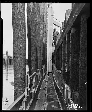
The Alaskan Way Seawall is a seawall which runs for approximately 7,166 feet (2,184 m) along the Elliott Bay waterfront southwest of downtown Seattle from Bay Street to S. Washington Street. The seawall is being rebuilt in the 2010s as part of a waterfront redevelopment megaproject estimated to cost over $1 billion.

<span class="mw-page-title-main">Washington State Route 525</span> Highway in Washington

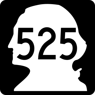
State Route 525 (SR 525) is a 30.68-mile-long (49.37 km) state highway located in Snohomish and Island counties in the western region of the U.S. state of Washington. SR 525 begins at an interchange with Interstate 5 (I-5) and I-405 in Lynnwood and travels north to SR 99 as a four-lane controlled-access freeway. From Lynnwood, the highway serves Mukilteo and becomes the terminus of SR 526 before taking its ferry route to Clinton on Whidbey Island. SR 525 traverses the island's interior as part of the Whidbey Island Scenic Byway before the designation ends at an intersection with SR 20 south of Coupeville.

<span class="mw-page-title-main">Washington State Route 16</span> State highway in the U.S. state of Washington

State Route 16 (SR 16) is a 27.16-mile-long (43.71 km) state highway in the U.S. state of Washington, connecting Pierce and Kitsap counties. The highway, signed as east–west, begins at an interchange with Interstate 5 (I-5) in Tacoma and travels through the city as a freeway towards the Tacoma Narrows. SR 16 crosses the narrows onto the Kitsap Peninsula on the partially tolled Tacoma Narrows Bridge and continues through Gig Harbor and Port Orchard before the freeway ends in Gorst. The designation ends at an intersection with SR 3 southwest of the beginning of its freeway through Bremerton and Poulsbo. SR 16 is designated as a Strategic Highway Network (STRAHNET) corridor within the National Highway System as the main thoroughfare connecting Tacoma to Naval Base Kitsap and a part of the Highways of Statewide Significance program.

<span class="mw-page-title-main">Washington State Route 526</span> Highway in Washington

State Route 526 (SR 526), also known as the Boeing Freeway, is a state highway in Snohomish County, Washington, United States. The east–west highway travels 4.52 miles (7.27 km) and connects SR 525 in Mukilteo to Interstate 5 (I-5) in southern Everett. The highway serves the Boeing Everett Factory and Paine Field; it also serves as a main route to the city of Mukilteo and the state-run ferry to Whidbey Island.

<span class="mw-page-title-main">Transportation in Seattle</span> Overview of transportation modes and routes in Seattle, Washington, U.S.

Transportation in Seattle is largely focused on the automobile like many other cities in western North America; however, the city is just old enough for its layout to reflect the age when railways and trolleys predominated. These older modes of transportation were made for a relatively well-defined downtown area and strong neighborhoods at the end of several former streetcar lines, now mostly bus lines.

<span class="mw-page-title-main">California State Route 480</span> Former highway in California

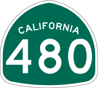
State Route 480 was a state highway in San Francisco, California, United States, consisting of the elevated double-decker Embarcadero Freeway, the partly elevated Doyle Drive approach to the Golden Gate Bridge and the proposed and unbuilt section in between. The unbuilt section from Doyle Drive to Van Ness Avenue was to have been called the Golden Gate Freeway and the Embarcadero Freeway as originally planned would have extended from Van Ness along the north side of Bay Street and then along the Embarcadero to the San Francisco-Oakland Bay Bridge.

The Washington State Department of Transportation is a governmental agency that constructs, maintains, and regulates the use of transportation infrastructure in the U.S. state of Washington. Established in 1905, it is led by a secretary and overseen by the governor. WSDOT is responsible for more than 20,000 lane-miles of roadway, nearly 3,000 vehicular bridges and 524 other structures. This infrastructure includes rail lines, state highways, state ferries and state airports.

<span class="mw-page-title-main">Washington State Route 202</span> State highway in King County, Washington, US

State Route 202 (SR 202) is a state highway in the U.S. state of Washington, serving part of the Seattle metropolitan area. It runs southeasterly for 31 miles (50 km) in the Eastside region of King County, connecting Woodinville, Redmond, Fall City, and North Bend. The highway begins at SR 522 in Woodinville, intersects SR 520 in Redmond and SR 203 in Fall City, and terminates at Interstate 90 (I-90) in North Bend. The entire highway is designated as the Cascade Valleys Scenic Byway, a state scenic and recreational highway.

<span class="mw-page-title-main">Washington State Route 524</span> Highway in Washington

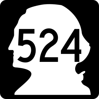
State Route 524 (SR 524) is a suburban state highway in the U.S. state of Washington, located entirely within Snohomish County. It begins at SR 104 in Edmonds and travels east past SR 99, Interstate 5 (I-5), under I-405, past SR 527 and SR 9 to end at SR 522 in Maltby. The road also has two spur routes, one connecting to SR 104 in Edmonds and another connecting to I-5 in Lynnwood.

<span class="mw-page-title-main">Interstate 90 in Washington</span> Interstate Highway in Washington

Interstate 90 (I-90), designated as the American Veterans Memorial Highway, is a transcontinental Interstate Highway that runs from Seattle, Washington, to Boston, Massachusetts. It crosses Washington state from west to east, traveling 298 miles (480 km) from Seattle across the Cascade Mountains and into Eastern Washington, reaching the Idaho state line east of Spokane. I-90 intersects several of the state's other major highways, including I-5 in Seattle, I-82 and U.S. Route 97 (US 97) near Ellensburg, and US 395 and US 2 in Spokane.

<span class="mw-page-title-main">Washington State Route 166</span> State highway in Kitsap County, Washington, US

State Route 166 (SR 166) is a 5.13-mile (8.26 km) long state highway serving the city of Port Orchard within Kitsap County in the U.S. state of Washington. The highway begins at an interchange with SR 16 west of Port Orchard and travels along the Sinclair Inlet to Downtown Port Orchard and ends as Mile Hill Drive at Whitter Avenue near the eastern city limits. SR 166 was originally a branch of State Road 14 and later Primary State Highway 14 (PSH 14) before being designated as SR 160 after the 1964 highway renumbering. SR 160 was moved south in 1993 and the old alignment through Port Orchard became SR 166, which was extended in 2010 to the eastern city limits.

<span class="mw-page-title-main">Washington State Route 304</span> State highway in northwestern Washington, US

State Route 304 (SR 304) is a state highway in Kitsap County, Washington, United States. It connects SR 3, a regional freeway, to the Puget Sound Naval Shipyard and downtown Bremerton. The designation of SR 304 continues onto the Seattle–Bremerton ferry operated by Washington State Ferries to Colman Dock in Downtown Seattle, terminating at SR 519 on Alaskan Way.

<span class="mw-page-title-main">Washington State Route 305</span> State highway in northwestern Washington, US

State Route 305 (SR 305) is a 13.50-mile-long (21.73 km) state highway in the U.S. state of Washington, primarily serving Bainbridge Island in Kitsap County and connecting it to Seattle in King County via the Seattle–Bainbridge Island ferry. The highway travels north through Bainbridge Island and leaves the island on the Agate Pass Bridge into the Kitsap Peninsula. SR 305 continues northwest through Poulsbo, intersecting SR 307 and ending at the SR 3 freeway. The highway was created during the 1964 highway renumbering and was preceded by Secondary State Highway 21A (SSH 21A), established in 1937. The ferry, part of the highway since 1994, is served by the Jumbo Mark-II-classMV Tacoma and MV Wenatchee and operates on a 35-minute crossing time.

<span class="mw-page-title-main">Alaskan Way</span> Street in Seattle, Washington

Alaskan Way, originally Railroad Avenue, is a street in Seattle, Washington, that runs along the Elliott Bay waterfront from just north of S. Holgate Street in the Industrial District—south of which it becomes East Marginal Way S.— to Broad Street in Belltown, north of which is Myrtle Edwards Park and the Olympic Sculpture Park. The right-of-way continues northwest through the park, just west of the BNSF Railway mainline, and the roadway picks up again for a few blocks at Smith Cove. It follows a route known in the late 19th century as the "Ram's Horn" because of its shape. The street gave its name to the Alaskan Way Viaduct, which until 2019 carried Washington State Route 99 through Downtown Seattle. The northern section of Alaskan Way is also signed as its honorary name, Dzidzilalich.

<span class="mw-page-title-main">Central Waterfront, Seattle</span> Neighborhood in Seattle

The Central Waterfront of Seattle, Washington, United States, is the most urbanized portion of the Elliott Bay shore. It runs from the Pioneer Square shore roughly northwest past Downtown Seattle and Belltown, ending at the Broad Street site of the Olympic Sculpture Park.

<span class="mw-page-title-main">State Route 99 tunnel</span> Highway tunnel in Seattle, Washington

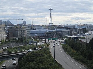
The State Route 99 tunnel, also known as the Alaskan Way Viaduct replacement tunnel, is a bored highway tunnel in the city of Seattle, Washington, United States. The 2-mile (3.2 km), double-decker tunnel carries a section of State Route 99 (SR 99) under Downtown Seattle from SoDo in the south to South Lake Union in the north.

<span class="mw-page-title-main">Colman Dock</span> Ferry terminal in Seattle, Washington, U.S.

Colman Dock, also called Pier 52, is the primary ferry terminal in Seattle, Washington, United States. The original pier is no longer in existence, but the terminal, now used by the Washington State Ferries system, is still called "Colman Dock". The terminal serves two routes to Bainbridge Island and Bremerton and has an adjacent passenger-only facility at Pier 50 for King County Water Taxi and Kitsap Fast Ferries routes.

<span class="mw-page-title-main">Mercer Street (Seattle)</span>

Mercer Street is a major east–west thoroughfare in the Lower Queen Anne and South Lake Union neighborhoods of Seattle, Washington. It travels 2 miles (3.2 km) and connects Elliott Avenue to the west and Interstate 5 to the east, serving as one of several downtown exits on the freeway. The street carries an average weekday volume of 38,000 vehicles on its central section.

References

  1. 1 2 3 Multimodal Planning Division (February 4, 2020). State Highway Log Planning Report 2019, SR 2 to SR 971 (PDF) (Report). Washington State Department of Transportation. pp. 1542–1543. Retrieved May 16, 2020.
  2. 1 2 "47.17.717: State route No. 519". Revised Code of Washington . Washington State Legislature. 1991. Retrieved February 2, 2013.
  3. 1 2 Vinh, Tan (March 6, 2005). "Slugger christens Edgar Martinez Drive". The Seattle Times . Retrieved February 2, 2013.
  4. "SR 519: Junction SR 90/Royal Brougham Way" (PDF). Washington State Department of Transportation. March 27, 2018. Retrieved March 10, 2021.
  5. 2011 Washington State Rail System (PDF) (Map). Washington State Department of Transportation. January 2012. Archived from the original (PDF) on June 12, 2013. Retrieved February 2, 2013.
  6. 1 2 Baker, Geoff (April 5, 2011). "Street outside Safeco Field to be named "Dave Niehaus Way South"". The Seattle Times. Retrieved March 10, 2021.
  7. 1 2 "Corridor Sketch Summary – SR 519: I-90 Jct to Seattle Ferry Terminal" (PDF). Washington State Department of Transportation. January 28, 2019. Retrieved March 10, 2021.
  8. Google (March 9, 2021). "State Route 519" (Map). Google Maps . Google. Retrieved March 9, 2021.
  9. "Traffic Data GeoPortal". Washington State Department of Transportation. Retrieved March 10, 2021.
  10. "Transportation Commission List of Highways of Statewide Significance" (PDF). Washington State Transportation Commission. July 26, 2009. Retrieved February 2, 2013.
  11. Dorpat, Paul (May 24, 2000). "Seattle Central Waterfront Tour, Part 6: From Railroad Avenue to Alaskan Way". HistoryLink . Retrieved February 2, 2013.
  12. Larson Anthropological Archaeological Services Limited (March 2004). "Draft Environmental Impact Statement - Appendix M: Archaeological Resources and Traditional Cultural Places Technical Memorandum" (PDF). Draft Environmental Impact Statement: SR 99: Alaskan Way Viaduct & Seawall Replacement Project. Washington State Department of Transportation. p. 67. Retrieved February 2, 2013.
  13. Ott, Jennifer (September 13, 2011). "Alaskan Way Viaduct, Part 1: Early Transportation Planning". HistoryLink. Retrieved February 2, 2013.
  14. Ott, Jennifer (December 19, 2011). "First section of Seattle's Alaskan Way Viaduct opens on April 4, 1953". HistoryLink. Retrieved February 2, 2013.
  15. Stein, Alan J. (June 2, 2001). "Turning Point 9: The Sound and the Ferry: The Birth of Washington State Ferries". HistoryLink. Retrieved February 2, 2013.
  16. Washington State Legislature (March 30, 1994). "Chapter 209: Substitute House Bill 2618 - Ferry Routes Included in State Highway Routes". Session Laws of the State of Washington (1994 ed.). Olympia, Washington: Washington State Legislature. Retrieved February 2, 2013. AN ACT Relating to state highway routes; amending RCW 47.17.080, 47.17.081, 47.17.175, 47.17.305, 47.17.317, 47.17.556, 47.17.560, and 47.17.735; and adding new sections to chapter 47.17 RCW.
  17. "SR 519 - S Seattle Intermodal Access - Complete May 2010". Washington State Department of Transportation. May 2010. Retrieved April 30, 2007.
  18. Staff (2010). "State Highway Log: Planning Report 2010, SR 2 to SR 971" (PDF). Washington State Department of Transportation. p. 5. Retrieved February 2, 2013.
  19. Washington State Department of Transportation (2004). Washington State Highways, 2004–2005 (PDF) (Map). 1:842,000. Olympia: Washington State Department of Transportation. Downtown Seattle inset. Archived from the original (PDF) on September 24, 2021. Retrieved September 27, 2021.
  20. SR 99 Tunnel Project: Keeping waterfront traffic moving during SR 99 tunnel construction (JPG) (Map). Washington State Department of Transportation. May 2012. Retrieved February 2, 2013.
  21. Lindblom, Mike (November 16, 2016). "'8-lane highway' on Seattle's waterfront? Critics challenge post-viaduct plan". The Seattle Times. Retrieved March 10, 2021.
Template:Attached KML/Washington State Route 519
KML is from Wikidata