State Route 512 | ||||
---|---|---|---|---|
Route information | ||||
Maintained by WSDOT | ||||
Length | 12.06 mi [1] (19.41 km) | |||
Existed | 1964–present | |||
Major junctions | ||||
West end | I-5 in Lakewood | |||
East end | SR 161 / SR 167 in Puyallup | |||
Location | ||||
Country | United States | |||
State | Washington | |||
Counties | Pierce | |||
Highway system | ||||
|
State Route 512 (SR 512) is a suburban state-maintained freeway in Pierce County, Washington, United States. It travels 12 miles (19 km) from west to east, connecting Interstate 5 (I-5) in Lakewood to SR 7 in Parkland and SR 167 in Puyallup. The freeway travels north–south through Puyallup, concurrent with SR 161.
The freeway follows the route of several county roads that were incorporated into Secondary State Highway 5G (SSH 5G) in 1937. The highway was renumbered to SR 512 in 1964 and gradually replaced by a freeway that was constructed between 1959 and 1973. The Puyallup section was initially built as a two-lane expressway until further funding was allocated by the state government to complete it as a four-lane freeway in 1976.
Further projects widened sections of SR 512 and added new interchanges to address increased demand caused by urban development along the freeway. Recent proposals have included interchange upgrades and the addition of high-occupancy vehicle lanes (HOV lanes).
SR 512 begins at a partial cloverleaf interchange with I-5 in Lakewood, a suburb of Tacoma in the Seattle metropolitan area. The interchange only uses three cloverleaf ramps, with turns from southbound I-5 to eastbound SR 512 allowed via a traffic signal; beyond the interchange, the highway continues west to an intersection with South Tacoma Way. [2] The six-lane freeway travels southeast along the north side of Joint Base Lewis–McChord and intersects Steele Street before it enters the suburban Parkland area. SR 512 then intersects Pacific Avenue (part of SR 7) at an interchange near the Pacific Lutheran University campus. [3] [4]
The freeway continues east with four lanes through Midland, where it passes under overpasses for school buses and the Tacoma Rail system, before an interchange with Portland Avenue near Franklin Pierce High School. [5] SR 512 then crosses over Swan Creek and enters the exurban area of Summit, where it passes residential subdivisions and farms that surround a junction with Canyon Road, the main route to the Frederickson industrial area. [6] The freeway travels into Puyallup and intersects 94th Avenue East on the west side of the South Hill Mall. It then turns north and reaches an interchange with SR 161 at 31st Avenue Southwest, marking the beginning of a concurrency between the two state routes. [3]
SR 512 and SR 161 continues north through the residential neighborhoods of Puyallup towards the Washington State Fairgrounds and turns east to intersect Meridian Street. The freeway then travels around downtown Puyallup to the east and intersects Pioneer Avenue before it crosses over the BNSF Railway's Seattle Subdivision tracks and the Puyallup River. [5] [7] SR 512 terminates shortly after crossing the river at a trumpet interchange with SR 167. [8] SR 161 travels west with SR 167 to an intersection with Meridian Avenue, which it follows to Federal Way; SR 167 continues east to Sumner and turns north onto the Valley Freeway. [3] [9]
SR 512 is maintained by the Washington State Department of Transportation (WSDOT), which conducts an annual survey on state highways to measure traffic volume in terms of average annual daily traffic. Average traffic volumes on the highway in 2016 ranged from a minimum of 44,000 vehicles at its eastern terminus with SR 167 to a maximum of 110,000 near its western terminus at I-5. [10] The entire route of SR 512 is designated as part of the National Highway System, a national network of roads identified as important to the national economy, defense, and mobility, [11] and is listed as a Highway of Statewide Significance by the state legislature. [12]
The first road to connect Fort Steilacoom and areas of modern-day Lakewood to the Puyallup Valley was Byrd's Mill Road, established in 1852 and designated by the Oregon territorial government as an official government road. It was later upgraded into a military road and saw use during the 1855 Puget Sound War to carry soldiers and evacuated settlers from the Puyallup Valley. [13] Byrd's Mill Road was designated as a state historical road in 1941 by the Washington state government, which funded the erection of historic markers at two sites. [14] [15]
By the turn of the 20th century, Lakeview (now Lakewood) was connected to Parkland and Puyallup by a series of country roads that were straightened in the early 1910s to form Lakeview–Puyallup Road (now 112th Street South). [16] [17] [18] The road remained graveled until a series of paving projects were completed by the county government in the 1920s and 1930s with funding from the state govrenment. [19] [20] [21] It was then incorporated into the state highway system in 1937 as Secondary State Highway 5G (SSH 5G), which connected Primary State Highway 5 (PSH 5) in Puyallup to PSH 1 in Lakeview. [16] [22] [23] The highway used a section of Meridian Avenue that was later co-signed with SSH 5N, which was created in 1955. [24] [25]
The state government approved plans for a network of limited-access freeways in July 1953, including SSH 5G as part of a system to serve Puyallup. [26] The freeway would connect PSH 1 (replaced by I-5) to the future Valley Freeway (PSH 5, now SR 167) in Puyallup. [27] [28] The first section opened on October 1, 1959, as part of the project to build I-5 through South Tacoma and connected the Lakewood interchange to Steele Street north of 112th Street (also known as Airport Road). [29] [30] Land along the next section of the freeway to Pacific Avenue (SR 7) was cleared of homes and other buildings by early 1959 and $859,000 in construction funds were approved by the state legislature that year. [31] [32] Construction on the 1.5-mile (2.4 km) extension to Pacific Avenue began in August 1962 and was completed in December 1963 after delays due to wet weather. [33] [34]
SSH 5G was replaced by SR 512 as part of a statewide renumbering of highways that took effect in January 1964; [35] SR 512 signage on the new freeway had already been installed with to reflect the change, despite the potential for public confusion. [34] The 1.6-mile (2.6 km) section from the partially completed Pacific Avenue overpass to Portland Avenue began construction in June 1965 and was opened to traffic on February 28, 1967. [36] The project, part of a $1.13 million contract, included the construction of a new railroad overpass and a pedestrian–school bus overpass at Franklin Pierce High School. [37] The high school's original football and track and field stadium was demolished to make way for the freeway, which bisected the campus; a new stadium was opened in 1963 using funds from the state government that were awarded as compensation. [38]
Plans for the Puyallup section of SR 512, including an elevated viaduct near downtown and four interchanges, were endorsed by the city council in 1966. [39] A cut in funds from the Highway Trust Fund announced by the federal government in January 1967 led to delays in construction, design work, and land acquisition for the remainder of the freeway from Parkland to Puyallup. [40] [41] The 3.5-mile (5.6 km) section from Portland Avenue to Canyon Road began construction in 1968 and was opened in August 1970. [42] [43] The state government revised its plans for the Puyallup section ahead of construction bidding in 1969. Parts of the freeway were reduced to a divided two-lane expressway in the interim to save costs on the $11 million elevated viaduct. [44] [45]
Construction of the freeway extension from Canyon Road to 94th Avenue in southern Puyallup began in August 1969 and was completed on April 25, 1972, following a nine-month delay due to poor weather conditions. [46] It cost $2.2 million to construct the 3-mile (4.8 km) section, which included a temporary connection to Meridian Avenue (SR 161) to bypass a congested section of 112th Street. [43] [47] Preliminary work on the two-lane expressway through Puyallup began in early 1971 under a $3.72 million contract that covered 2.5 miles (4.0 km) between SR 161 and Pioneer Avenue. [48] [49] Over 1.25 million square yards (1,050,000 m2) of earth was excavated to make way for the freeway through a cut in South Hill near the Washington State Fairgrounds. [50] The Puyallup section—including one of two bridges over the Puyallup River—was dedicated and opened to traffic on December 13, 1973, completing the link to a partial interchange with SR 167. [51] [52]
The state government approved $3 million in funds to replace the two-lane expressway in Puyallup with a four-lane freeway in late 1973 through the construction of new bridges and overpasses. [53] [54] The northbound bridge over the Puyallup River opened on August 8, 1975, following additional work to repair a structural deficiency in a pier and weather delays. [55] [56] The final part of the widening project, a larger interchange to connect SR 512 with SR 167, was completed in July 1976 at a cost of $1.4 million. [57] SR 161 was moved from Meridian Avenue onto SR 512 by 1975, creating a concurrency around downtown Puyallup. [58]
The freeway's interchange with Pacific Avenue was rebuilt in 1983 to add a loop ramp to replace a left turn onto westbound SR 512. [59] [60] An additional interchange was planned in the 1960s east of Pacific Avenue to serve the Mountain Freeway (to be part of SR 7), which was ultimately never built. [61] [62] The westernmost section of SR 512, between I-5 and SR 7, was widened to eight lanes in 1989 to address congestion between the two major highways. [63] [64]
Increased residential and commercial development in Puyallup's South Hill, including the opening of the South Hill Mall in 1989, brought more traffic and congestion to the SR 512 corridor. [65] Several ideas to mitigate the increased traffic were proposed and studied, including high-occupancy vehicle lanes (HOV lanes) on SR 512, [66] improved bus service, and the construction of the Cross-Base Highway to provide a southern bypass of McChord Air Force Base. [67] Pierce Transit opened a park and ride at the freeway's western terminus in 1988, [68] which was followed by a transit center at the South Hill Mall in 1999 alongside increased bus service. [69]
The mall's first major expansion was planned in the early 1990s and was to include an infill interchange and additional park and ride lot as part of traffic mitigation. [70] [71] A half-diamond interchange was built at 94th Avenue East in 1997 at a cost of $4.6 million; [72] [73] a park and ride at its northwest corner was opened two years later in response to the use of mall parking lots by commuters. [74] [75] WSDOT also completed construction of a westbound truck lane between downtown Puyallup and South Hill in 1994. [76]
The cloverleaf interchange with I-5 in Lakewood was modified in the late 1990s[ when? ] to remove the southbound onramp to SR 512 after it had become too congested; by 1994, approximately 20,000 vehicles used the interchange on a daily basis. [77] To eliminate the weaving between traffic entering and exiting via the southbound ramps, the southbound loop to eastbound SR 512 was replaced by a traffic signal on the existing outer ramp to South Tacoma Way. [78] A ramp meter—the first in Pierce County—was installed in 1994 for traffic entering southbound I-5 from SR 512. [77] The traffic signal was intended to be an interim solution until a flyover ramp connecting to eastbound SR 512 could be constructed with additional funding, which had not been granted. [79]
WSDOT has studied additional projects to address congestion on sections of SR 512, particularly near I-5 and the South Hill Mall. Their long-term plans for HOV lanes on I-5 through Pierce County include an unfunded proposal to fully rebuild the SR 512 interchange and the Steele Street bridge. [80] [81] Ramp meters were added to the Steele Street and SR 7 interchanges on SR 512 in 2016 to control westbound traffic during peak periods; WSDOT plans to add ramp meters to all interchanges on SR 512 in both directions when funding is available. [82] The SR 161/31st Avenue Southwest interchange near South Hill gained an additional traffic signal and turn lane in 2021 as part of improvements to roads around the mall. [83]
The entire route is in Pierce County. All exits are unnumbered.
Location | mi [1] | km | Destinations | Notes | |
---|---|---|---|---|---|
Lakewood | 0.00 | 0.00 | South Tacoma Way I-5 – Tacoma, Seattle, Portland | ||
0.63 | 1.01 | Steele Street | |||
Parkland | 2.22 | 3.57 | SR 7 (Pacific Avenue) – Parkland, Spanaway | ||
Midland | 3.71 | 5.97 | Portland Avenue – Midland | ||
Summit | 5.86 | 9.43 | Canyon Road – Summit | ||
Puyallup | 8.37 | 13.47 | 9th Street Southwest, 94th Avenue East | Eastbound exit and westbound entrance | |
8.74 | 14.07 | SR 161 – South Hill, Eatonville | West end of SR 161 overlap | ||
10.06 | 16.19 | Meridian Avenue South – Puyallup | |||
11.12 | 17.90 | Pioneer Avenue East – Orting, Puyallup | Former SR 162 | ||
12.06 | 19.41 | SR 161 north / SR 167 to SR 410 east – Milton, Tacoma, Seattle, Yakima | East end of SR 161 overlap | ||
1.000 mi = 1.609 km; 1.000 km = 0.621 mi
|
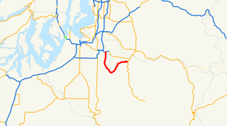
Interstate 705 is a short Interstate Highway that is spur route of I-5 located entirely within Tacoma, Washington, United States. The freeway serves as the connector between I-5, Downtown Tacoma, Tacoma's waterfront, North Tacoma, and the Tacoma Dome. I-705 was the last new portion of the Interstate Highway System to be constructed in Washington, having opened in 1988.
State Route 99 (SR 99), also known as the Pacific Highway, is a state highway in the Seattle metropolitan area, part of the U.S. state of Washington. It runs 49 miles (79 km) from Fife in the south to Everett in the north, passing through the cities of Federal Way, SeaTac, Seattle, Shoreline, and Lynnwood. The route primarily follows arterial streets, including Aurora Avenue, and has several freeway segments, including the tolled SR 99 Tunnel in Downtown Seattle. SR 99 was officially named the William P. Stewart Memorial Highway by the state legislature in 2016, after a campaign to replace an unofficial moniker honoring Confederate president Jefferson Davis.
The St. Joseph Valley Parkway is a freeway in the U.S. states of Indiana and Michigan, serving as a bypass route around Elkhart, Mishawaka, and South Bend in Indiana and Niles in Michigan. The freeway runs to the south and west of Elkhart and South Bend and Niles and consists of segments of U.S. Route 31 (US 31) and US 20; those two highway designations run concurrently at the southwestern rim of the South Bend metropolitan area. It continues north to run along the St. Joseph River valley.
State Route 16 (SR 16) is a 27.16-mile-long (43.71 km) state highway in the U.S. state of Washington, connecting Pierce and Kitsap counties. The highway, signed as east–west, begins at an interchange with Interstate 5 (I-5) in Tacoma and travels through the city as a freeway towards the Tacoma Narrows. SR 16 crosses the narrows onto the Kitsap Peninsula on the partially tolled Tacoma Narrows Bridge and continues through Gig Harbor and Port Orchard before the freeway ends in Gorst. The designation ends at an intersection with SR 3 southwest of the beginning of its freeway through Bremerton and Poulsbo. SR 16 is designated as a Strategic Highway Network (STRAHNET) corridor within the National Highway System as the main thoroughfare connecting Tacoma to Naval Base Kitsap and a part of the Highways of Statewide Significance program.
State Route 509 (SR 509) is a 35.17-mile-long (56.60 km) state highway in the U.S. state of Washington, connecting Tacoma in Pierce County to Seattle in King County. The highway travels north from Interstate 705 (I-705) in Tacoma to SR 99 south of downtown Seattle. It serves cities along the Puget Sound and west of Seattle–Tacoma International Airport in south King County, including Federal Way, Des Moines, and Burien. SR 509 is part of the National Highway System and is a limited-access highway near the Port of Tacoma and from Burien to its northern terminus in Seattle.
Interstate 205 (I-205) is an auxiliary Interstate Highway in the Portland metropolitan area of Oregon and Washington. The north–south freeway serves as a bypass route of I-5 along the east side of Portland, Oregon, and Vancouver, Washington. It intersects several major highways and serves Portland International Airport.
State Route 18 (SR 18) is a 28.41-mile-long (45.72 km) state highway in the U.S. state of Washington, serving southeastern King County. The highway travels northeast, primarily as a controlled-access freeway, from an intersection with SR 99 and an interchange with Interstate 5 (I-5) in Federal Way through the cities of Auburn, Kent, Covington, and Maple Valley. SR 18 becomes a two-lane rural highway near Tiger Mountain as it approaches its eastern terminus, an interchange with I-90 near the cities of Snoqualmie and North Bend.
State Route 410 is a 107.44-mile (172.91 km) long state highway that traverses Pierce, King, and Yakima counties in the US state of Washington. It begins at an interchange with SR 167 in Sumner and travels southeast across the Cascade Range to a junction with U.S. Route 12 (US 12) in Naches. While the western part of SR 410 is a freeway that serves built-up, urban areas, the remainder of the route is a surface road that traverses mostly rural areas as it passes through the mountains.
State Route 167 (SR 167) is a state highway in the Seattle metropolitan area of Washington state. It is commonly known as the Valley Freeway and serves the Green River Valley from Tacoma to Renton, primarily as a four-lane freeway. The 28-mile (45 km) highway begins in Tacoma at an interchange with Interstate 5 (I-5) and travels southeast to Puyallup as an undivided road. It then turns northeast onto a freeway and passes through interchanges with SR 512 in Puyallup and SR 410 in Sumner, continuing north through Auburn and Kent. After an interchange with I-405 in Renton, it terminates at an intersection with SR 900.
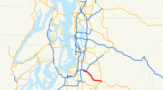
State Route 7 (SR 7) is a state highway in Lewis and Pierce counties, located in the U.S. state of Washington. The 58.60-mile (94.31 km) long roadway begins at U.S. Route 12 (US 12) in Morton and continues north to intersect several other state highways to Tacoma, where it ends at an interchange with Interstate 5 (I-5) and I-705. The road has several names, such as Second Street in Morton, the Mountain Highway in rural areas, Pacific Avenue in Spanaway, Parkland and Tacoma and 38th Street in Tacoma. Near the end of the highway there is a short freeway that has been proposed to be extended south parallel to an already existing railroad, owned by Tacoma Rail, which serves as the median of the short freeway.
In the U.S. state of Arizona, Interstate 10 (I‑10), the major east–west Interstate Highway in the United States Sun Belt, runs east from California, enters Arizona near the town of Ehrenberg and continues through Phoenix and Tucson and exits at the border with New Mexico near San Simon. The highway also runs through the cities of Casa Grande, Eloy, and Marana. Segments of the highway are referred to as either the Papago Freeway, Inner Loop, or Maricopa Freeway within the Phoenix area and the Pearl Harbor Memorial Highway outside metro Phoenix.
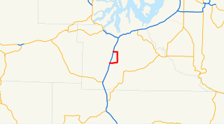
State Route 704 is a state highway located entirely in Pierce County, Washington, United States. It is intended to provide access between Interstate 5 (I-5) and SR 7 by passing through a portion of Joint Base Lewis–McChord, a major U.S. military installation. The designated route comprises a short, 0.6-mile (0.97 km) section near SR 7 in Spanaway. The full 6-mile (9.7 km) highway is estimated to cost $480 million to construct, but remains unfunded.
State Route 161 (SR 161) is a 36.25-mile-long (58.34 km) state highway serving Pierce and King counties in the U.S. state of Washington. The highway begins at SR 7 southwest of Eatonville and travels north as Meridian Avenue to Puyallup, becoming concurrent with SR 512 and SR 167. SR 161 continues northwest as the Enchanted Parkway to end at an intersection with SR 18 in Federal Way, west of Interstate 5 (I-5). The highway serves the communities of Graham and South Hill before reaching Puyallup and the communities of Edgewood, Milton, and Lakeland South before reaching Federal Way.
Interstate 90 (I-90), designated as the American Veterans Memorial Highway, is a transcontinental Interstate Highway that runs from Seattle, Washington, to Boston, Massachusetts. It crosses Washington state from west to east, traveling 298 miles (480 km) from Seattle across the Cascade Mountains and into Eastern Washington, reaching the Idaho state line east of Spokane. I-90 intersects several of the state's other major highways, including I-5 in Seattle, I-82 and U.S. Route 97 (US 97) near Ellensburg, and US 395 and US 2 in Spokane.
Interstate 5 (I-5) is an Interstate Highway on the West Coast of the United States, serving as the region's primary north–south route. It travels 277 miles (446 km) across the state of Washington, running from the Oregon state border at Vancouver, through the Puget Sound region, and to the Canadian border at Blaine. Within the Seattle metropolitan area, the freeway connects the cities of Tacoma, Seattle, and Everett.
State Route 121 (SR 121) is a state highway located entirely in Thurston County, Washington, United States. The highway serves Millersylvania State Park, forming a 7.67-mile (12.34 km) loop between two interchanges with Interstate 5 (I-5) near Maytown. It is an auxiliary route of U.S. Route 12 (US 12).
State Route 162 (SR 162) is a 17.37-mile-long (27.95 km) state highway in the U.S. state of Washington, serving rural Pierce County. The highway travels from an interchange with SR 410 in Sumner and travels south along the Puyallup River to Orting and northeast to South Prairie, ending at an intersection with SR 165 near Buckley. SR 162 was established in 1964 as the successor to Secondary State Highway 5E (SSH 5E), which was codified in 1937. The highway crossed the Puyallup River northwest of Orting on the McMillin Bridge, which opened in 1934 and was replaced with a newer bridge that opened in 2015.
State Route 164 (SR 164) is a 14.82-mile-long (23.85 km) state highway serving southern King County in the U.S. state of Washington. The highway, which connects Auburn and Enumclaw along the White River, begins at an interchange with SR 18 in Auburn and travels southeast to Enumclaw, where it intersects SR 169 and ends at SR 410. SR 164 serves as an alternate route towards Buckley and Chinook Pass, via SR 410, and also passes the Muckleshoot Indian Reservation.
State Route 290 (SR 290), named Hamilton Street and Trent Avenue, is an 18.38-mile (29.58 km) long state highway serving Spokane County in the U.S. state of Washington. SR 290 travels parallel to a Union Pacific railroad from Interstate 90 (I-90) in Spokane through Millwood and across the Spokane River thrice towards Spokane Valley, where the highway intersects SR 27. From Spokane Valley, the roadway continues to the Idaho state border, where it becomes Idaho State Highway 53.
U.S. Route 31 (US 31) is a part of the United States Numbered Highway System that runs from Spanish Fort, Alabama, to Mackinaw City, Michigan. It enters the U.S. state of Indiana via the George Rogers Clark Memorial Bridge between Louisville, Kentucky, and Clarksville, Indiana. The 266.02 miles (428.12 km) of US 31 that lie within Indiana serve as a major conduit. Some of the highway is listed on the National Highway System. Various sections are rural two-lane highway and urbanized four- or six-lane divided expressway. The northernmost community along the highway is South Bend near the Michigan state line.
{{cite report}}
: CS1 maint: url-status (link){{cite map}}
: CS1 maint: url-status (link) KML file (edit • help) |