
Wellington County is a county located in Southwestern Ontario, Canada and is part of the Greater Golden Horseshoe. The County, made up of two towns and five townships, is predominantly rural in nature. However many of the residents in the southern part of the County commute to urban areas such as Guelph, Kitchener, Waterloo, Brampton, Mississauga, Toronto and Hamilton for employment. The northern part of the county is made up of mainly rural farming communities, except for a few larger towns such as Mount Forest and Arthur. According to the 2016 Census, the population of the County was 90,932.

Renfrew County is a county in the Canadian province of Ontario. It stands on the west bank of the Ottawa River. There are 17 municipalities in the county.
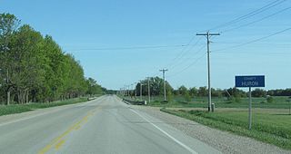
Huron County is a county of the province of Ontario, Canada. It is located on the southeast shore of its namesake, Lake Huron, in the southwest part of the province. The county seat is Goderich, also the county's largest community.

Grey County is a county of the Canadian province of Ontario. The county seat is in Owen Sound. It is located in the subregion of Southern Ontario named Southwestern Ontario. Grey County is also a part of the Georgian Triangle. At the time of the Canada 2016 Census the population of the County was 93,830.
Halton County is a former county in the Canadian province of Ontario, with an area of 228,181 acres (923.42 km2). It is also one of the oldest counties in Canada.

Peel County is a historic county in the Canadian province of Ontario. Named for Sir Robert Peel, Prime Minister of the United Kingdom, the county was organized in 1851. Settlers, however, were in Toronto Township as early as 1807. The Credit River was reserved for the Mississaugas, however they sold their land and moved to the Bruce Peninsula.

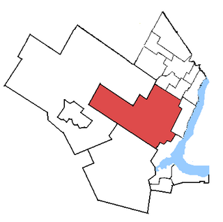
Wellington—Halton Hills is a federal electoral district in Ontario, Canada, that has been represented in the House of Commons of Canada since 2004.
Wellington North was a federal electoral district represented in the House of Commons of Canada from 1867 to 1953. It was located in the province of Ontario.
Wellington—Huron was a federal electoral district represented in the House of Commons of Canada from 1953 to 1968. It was located in the province of Ontario. This riding was created in 1952 from parts of Huron North, Wellington North and Wellington South ridings.
Wellington—Grey, renamed Wellington—Grey—Dufferin—Waterloo in 1970, was a federal electoral district represented in the House of Commons of Canada from 1968 to 1979. It was located in the province of Ontario. This riding was created in 1966 from parts of Dufferin—Simcoe, Grey—Bruce, Waterloo North, Wellington South and Wellington—Huron ridings.
Wellington—Dufferin—Simcoe was a federal electoral district represented in the House of Commons of Canada from 1979 to 1988. It was located in the province of Ontario. This riding was created in 1976 as Dufferin—Wellington and renamed in 1977. It was created from parts of Halton, Peel—Dufferin—Simcoe and Wellington—Grey—Dufferin—Waterloo ridings.
Perth—Wellington—Waterloo was a federal electoral district represented in the House of Commons of Canada from 1988 to 1997. It was located in the province of Ontario. This riding was created in 1987 from parts of Perth, Waterloo and Wellington—Dufferin—Simcoe ridings.
Wellington—Grey—Dufferin—Simcoe was a federal electoral district represented in the House of Commons of Canada from 1988 to 1997. It was located in the province of Ontario. This riding was created in 1987 from parts of Bruce—Grey, Grey—Simcoe and Wellington—Dufferin—Simcoe ridings.
Waterloo—Wellington was a federal electoral district represented in the House of Commons of Canada from 1997 to 2003. It continued to be a provincial electoral district represented in the Legislative Assembly of Ontario until the 2007 provincial election.

The Home District was one of four districts of the Province of Quebec created in 1788 in the western reaches of the Montreal District and detached in 1791 to create the new colony of Upper Canada. It was abolished with the adoption of the county system in 1849.
The London District was a historic district in Upper Canada. It was formed in 1798 from parts of the Home and Western Districts, and lasted until its abolition in 1850.
The Niagara District was a historic district in Upper Canada. Created in 1798 from the Home District, it existed until 1849.

The Bathurst District was a historic district in Upper Canada. It was created in 1822 from the Johnstown District. Containing Carleton County, it existed until 1849. The district town was Perth.
Halton was a provincial electoral district in Central Ontario, Canada. It elected one member to the Legislative Assembly of Ontario.
Halton West was an electoral district of the Legislative Assembly of the Parliament of the Province of Canada, in Canada West. It was created in 1841, upon the establishment of the Province of Canada by the union of Upper Canada and Lower Canada. It was based on the western portion of Halton County, termed a riding.

