Wells, Kansas | |
|---|---|
 | |
 Wells  Wells | |
| Coordinates: 39°08′21″N97°33′04″W / 39.13917°N 97.55111°W [1] | |
| Country | United States |
| State | Kansas |
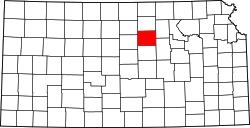
| County | Ottawa |
| Elevation | 1,371 ft (418 m) |
| Population | |
• Total | 45 |
| Time zone | UTC-6 (CST) |
| • Summer (DST) | UTC-5 (CDT) |
| Area code | 785 |
| FIPS code | 20-76550 |
| GNIS ID | 2804518 [1] |
Wells is a census-designated place (CDP) in Ottawa County, Kansas, United States. [1] As of the 2020 census, the population was 45. [2]