Bennington, Kansas

Last updated

Bennington, Kansas
Ottawa County Kansas Incorporated and Unincorporated areas Bennington Highlighted.svg
Location within Ottawa County and Kansas
Map of Ottawa Co, Ks, USA.png
Coordinates: 39°1′59″N97°35′36″W / 39.03306°N 97.59333°W / 39.03306; -97.59333 [1]
Country United States
State Kansas
County Ottawa
Founded1870s
Platted 1878
Incorporated 1885
Named for Bennington, Vermont
Government
  Type Mayor–Council
   Mayor Ward Stockhamp [2] [3]
Area
[4]
  Total0.42 sq mi (1.09 km2)
  Land0.42 sq mi (1.09 km2)
  Water0.00 sq mi (0.00 km2)
Elevation
[1]
1,230 ft (370 m)
Population
 (2020) [5]
  Total622
  Density1,500/sq mi (570/km2)
Time zone UTC-6 (CST)
  Summer (DST) UTC-5 (CDT)
ZIP code
67422 [6]
Area code 785, exchange 488
FIPS code 20-06075
GNIS ID 2394136 [1]
Website cityofbennington.com

Bennington is a city in Ottawa County, Kansas, United States. [1] As of the 2020 census, the population of the city was 622. [5]

Contents

History

19th century

Bennington was platted in 1878 and grew to a population of over 200 within three years. [7] The city name comes from one of two sources. A paper written on the history of Bennington states that Bennington is an Indian name meaning "place of fine trees." The same article also states that co-city founder George R. Parker gave the town its name after Bennington, Vermont. [8] The Solomon Valley Railroad, a branch of the Kansas Pacific Railroad, reached Bennington in 1878. [7]

In 1879, the first school was located one half mile south of town. In 1918, a new school house was built. In 1938, an auditorium was added; in 1955 a shop was added; and in 1961 a new grade school building was annexed. [7]

Geography

According to the United States Census Bureau, the city has a total area of 0.42 square miles (1.09 km2), all of it land. [9]

Climate

The climate in this area is characterized by hot, humid summers and generally mild to cool winters. According to the Köppen Climate Classification system, Bennington has a humid subtropical climate, abbreviated "Cfa" on climate maps. [10]

Demographics

Historical population
CensusPop.Note
1890 390
1900 389−0.3%
1910 386−0.8%
1920 371−3.9%
1930 3740.8%
1940 369−1.3%
1950 325−11.9%
1960 53564.6%
1970 5614.9%
1980 5793.2%
1990 568−1.9%
2000 6239.7%
2010 6727.9%
2020 622−7.4%
U.S. Decennial Census

Bennington is part of the Salina Micropolitan Statistical Area.

2020 census

The 2020 United States census counted 622 people, 254 households, and 163 families in Bennington. [11] [12] The population density was 1,481.0 per square mile (571.8/km2). There were 270 housing units at an average density of 642.9 per square mile (248.2/km2). [12] [13] The racial makeup was 91.8% (571) white or European American (91.0% non-Hispanic white), 0.32% (2) black or African-American, 0.48% (3) Native American or Alaska Native, 0.0% (0) Asian, 0.0% (0) Pacific Islander or Native Hawaiian, 0.16% (1) from other races, and 7.23% (45) from two or more races. [14] Hispanic or Latino of any race was 2.25% (14) of the population. [15]

Of the 254 households, 29.9% had children under the age of 18; 49.6% were married couples living together; 24.0% had a female householder with no spouse or partner present. 28.7% of households consisted of individuals and 15.4% had someone living alone who was 65 years of age or older. [12] The average household size was 2.2 and the average family size was 2.5. [16] The percent of those with a bachelor’s degree or higher was estimated to be 23.0% of the population. [17]

24.8% of the population was under the age of 18, 6.6% from 18 to 24, 26.0% from 25 to 44, 25.2% from 45 to 64, and 17.4% who were 65 years of age or older. The median age was 40.1 years. For every 100 females, there were 103.3 males. [12] For every 100 females ages 18 and older, there were 103.5 males. [12]

The 2016-2020 5-year American Community Survey estimates show that the median household income was $67,143 (with a margin of error of +/- $13,979) and the median family income was $73,913 (+/- $5,512). [18] Males had a median income of $40,703 (+/- $5,196) versus $23,594 (+/- $10,436) for females. The median income for those above 16 years old was $32,365 (+/- $2,567). [19] Approximately, 13.0% of families and 16.5% of the population were below the poverty line, including 37.1% of those under the age of 18 and 0.0% of those ages 65 or over. [20] [21]

2010 census

As of the census [22] of 2010, there were 672 people, 261 households, and 188 families residing in the city. The population density was 1,600.0 inhabitants per square mile (617.8/km2). There were 283 housing units at an average density of 673.8 per square mile (260.2/km2). The racial makeup of the city was 97.8% White, 0.3% African American, 0.9% Native American, and 1.0% from two or more races. Hispanic or Latino of any race were 1.9% of the population.

There were 261 households, of which 37.2% had children under the age of 18 living with them, 61.7% were married couples living together, 7.7% had a female householder with no husband present, 2.7% had a male householder with no wife present, and 28.0% were non-families. 25.7% of all households were made up of individuals, and 8.8% had someone living alone who was 65 years of age or older. The average household size was 2.57 and the average family size was 3.07.

The median age in the city was 37.4 years. 28.4% of residents were under the age of 18; 6.5% were between the ages of 18 and 24; 27.3% were from 25 to 44; 25% were from 45 to 64; and 12.9% were 65 years of age or older. The gender makeup of the city was 52.8% male and 47.2% female.

2000 census

As of the census [23] of 2000, there were 623 people, 245 households, and 182 families residing in the city. The population density was 1,474.4 inhabitants per square mile (569.3/km2). There were 266 housing units at an average density of 629.5 per square mile (243.1/km2). The racial makeup of the city was 97.75% White, 0.16% African American, 0.16% Native American, 0.16% Asian, 0.16% Pacific Islander, 0.32% from other races, and 1.28% from two or more races. Hispanic or Latino of any race were 0.96% of the population.

There were 245 households, out of which 37.6% had children under the age of 18 living with them, 60.8% were married couples living together, 9.8% had a female householder with no husband present, and 25.7% were non-families. 21.6% of all households were made up of individuals, and 10.2% had someone living alone who was 65 years of age or older. The average household size was 2.54 and the average family size was 2.96.

In the city, the population was spread out, with 31.0% under the age of 18, 3.9% from 18 to 24, 31.0% from 25 to 44, 22.2% from 45 to 64, and 12.0% who were 65 years of age or older. The median age was 35 years. For every 100 females, there were 95.9 males. For every 100 females age 18 and over, there were 93.7 males.

The median income for a household in the city was $37,303, and the median income for a family was $45,972. Males had a median income of $32,143 versus $21,429 for females. The per capita income for the city was $15,919. About 5.1% of families and 6.0% of the population were below the poverty line, including 5.8% of those under age 18 and 6.0% of those age 65 or over.

Government

The Bennington government consists of a mayor and five council members. The council meets the 2nd and 4th Monday of each month at 7 pm. [2] [3]

Education

The community is served by Twin Valley USD 240 public school district.

See also

Related Research Articles

<span class="mw-page-title-main">Hardtner, Kansas</span> City in Kiowa County, Kansas

Hardtner is a city in Barber County, Kansas, United States. As of the 2020 census, the population of the city was 167. It is located 1 mile north of the Kansas / Oklahoma state border.

<span class="mw-page-title-main">Chapman, Kansas</span> City in Dickinson County, Kansas

Chapman is a city in Dickinson County, Kansas, United States. As of the 2020 census, the population of the city was 1,377.

<span class="mw-page-title-main">Hill City, Kansas</span> City in Graham County, Kansas

Hill City is a city and county seat of Graham County, Kansas, United States. As of the 2020 census, the population of the city was 1,403.

<span class="mw-page-title-main">Eureka, Kansas</span> City in Greenwood County, Kansas

Eureka is a city in and the county seat of Greenwood County, Kansas, United States. As of the 2020 census, the population of the city was 2,332.

<span class="mw-page-title-main">Jetmore, Kansas</span> City in Hodgeman County, Kansas

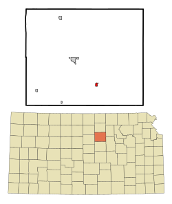
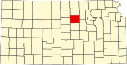
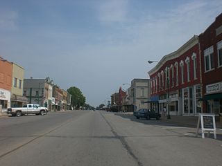
Jetmore is a city in and the county seat of Hodgeman County, Kansas, United States. As of the 2020 census, the population of the city was 770.

<span class="mw-page-title-main">Cunningham, Kansas</span> City in Kingman County, Kansas

Cunningham is a city in Kingman County, Kansas, United States. As of the 2020 census, the population of the city was 444. The city was named in honor of J.D. Cunningham, a pioneer settler.

<span class="mw-page-title-main">Mullinville, Kansas</span> City in Kiowa County, Kansas

Mullinville is a city in Kiowa County, Kansas, United States. As of the 2020 census, the population of the city was 197.

<span class="mw-page-title-main">Linwood, Kansas</span> City in Kansas, United States

Linwood is a city in Leavenworth County, Kansas, United States, and part of the Kansas City metropolitan area. As of the 2020 census, the population of the city was 415. It is located along K-32 highway between Lawrence and Bonner Springs.

<span class="mw-page-title-main">Pleasanton, Kansas</span> City in Kansas, United States

Pleasanton is a city in Linn County, Kansas, United States. As of the 2020 census, the population of the city was 1,208.

<span class="mw-page-title-main">Reading, Kansas</span> City in Lyon County, Kansas

Reading is a city in Lyon County, Kansas, United States. As of the 2020 census, the population of the city was 181.

<span class="mw-page-title-main">Meade, Kansas</span> City in Meade County, Kansas

Meade is a city in and the county seat of Meade County, Kansas, United States. As of the 2020 census, the population of the city was 1,505.

<span class="mw-page-title-main">Beloit, Kansas</span> City in Mitchell County, Kansas

Beloit is a city in and the county seat of Mitchell County, Kansas, United States. As of the 2020 census, the population of the city was 3,404.

<span class="mw-page-title-main">Dearing, Kansas</span> City in Montgomery County, Kansas

Dearing is a city in Montgomery County, Kansas, United States. As of the 2020 census, the population of the city was 382.

<span class="mw-page-title-main">Bern, Kansas</span> City in Nemaha County, Kansas

Bern is a city in Nemaha County, Kansas, United States. As of the 2020 census, the population of the city was 161.

<span class="mw-page-title-main">Ness City, Kansas</span> City in Ness County, Kansas

Ness City is a city in and the county seat of Ness County, Kansas, United States. As of the 2020 census, the population of the city was 1,329. Ness City is famous for its four-story Old Ness County Bank Building located downtown, and nicknamed Skyscraper of the Plains.

<span class="mw-page-title-main">Haysville, Kansas</span> City in Sedgwick County, Kansas

Haysville is a city in Sedgwick County, Kansas, United States, and a suburb of Wichita. As of the 2020 census, the population of the city was 11,262. Haysville is known as the "Peach Capital of Kansas".

<span class="mw-page-title-main">Oxford, Kansas</span> City in Sumner County, Kansas

Oxford is a city in Sumner County, Kansas, United States. As of the 2020 census, the population of the city was 1,048.

<span class="mw-page-title-main">Harveyville, Kansas</span> City in Wabaunsee County, Kansas

Harveyville is a city in Wabaunsee County, Kansas, United States. As of the 2020 census, the population of the city was 178. It is located 8.5 miles (13.7 km) northwest of the city of Burlingame.

<span class="mw-page-title-main">Greenleaf, Kansas</span> City in Washington County, Kansas

Greenleaf is a city in Washington County, Kansas, United States. As of the 2020 census, the population of the city was 350.

<span class="mw-page-title-main">Bennington, Nebraska</span> City in Douglas County, Nebraska, United States

Bennington is a city in Douglas County, Nebraska, United States. The population was 2,026 at the 2020 U.S. Census.

References

  1. 1 2 3 4 U.S. Geological Survey Geographic Names Information System: Bennington, Kansas
  2. 1 2 Bennington - Directory of Public Officials Archived December 13, 2011, at the Wayback Machine
  3. 1 2 Bennington - Government Archived September 24, 2014, at the Wayback Machine
  4. "2019 U.S. Gazetteer Files". United States Census Bureau. Retrieved July 24, 2020.
  5. 1 2 "Profile of Bennington, Kansas in 2020". United States Census Bureau. Archived from the original on December 12, 2021. Retrieved December 12, 2021.
  6. United States Postal Service (2012). "USPS - Look Up a ZIP Code" . Retrieved February 15, 2012.
  7. 1 2 3 History of Bennington Archived May 13, 2012, at the Wayback Machine
  8. History of Bennington (continued) Archived May 14, 2012, at the Wayback Machine
  9. "US Gazetteer files 2010". United States Census Bureau. Archived from the original on July 2, 2012. Retrieved July 6, 2012.
  10. Climate Summary for Bennington, Kansas
  11. "US Census Bureau, Table P16: HOUSEHOLD TYPE". data.census.gov. Retrieved January 2, 2024.
  12. 1 2 3 4 5 "US Census Bureau, Table DP1: PROFILE OF GENERAL POPULATION AND HOUSING CHARACTERISTICS". data.census.gov. Retrieved January 2, 2024.
  13. Bureau, US Census. "Gazetteer Files". Census.gov. Retrieved December 30, 2023.
  14. "US Census Bureau, Table P1: RACE". data.census.gov. Retrieved January 2, 2024.
  15. "US Census Bureau, Table P2: HISPANIC OR LATINO, AND NOT HISPANIC OR LATINO BY RACE". data.census.gov. Retrieved January 2, 2024.
  16. "US Census Bureau, Table S1101: HOUSEHOLDS AND FAMILIES". data.census.gov. Retrieved January 2, 2024.
  17. "US Census Bureau, Table S1501: EDUCATIONAL ATTAINMENT". data.census.gov. Retrieved January 2, 2024.
  18. "US Census Bureau, Table S1903: MEDIAN INCOME IN THE PAST 12 MONTHS (IN 2020 INFLATION-ADJUSTED DOLLARS)". data.census.gov. Retrieved January 2, 2024.
  19. "US Census Bureau, Table S2001: EARNINGS IN THE PAST 12 MONTHS (IN 2020 INFLATION-ADJUSTED DOLLARS)". data.census.gov. Retrieved January 2, 2024.
  20. "US Census Bureau, Table S1701: POVERTY STATUS IN THE PAST 12 MONTHS". data.census.gov. Retrieved January 2, 2024.
  21. "US Census Bureau, Table S1702: POVERTY STATUS IN THE PAST 12 MONTHS OF FAMILIES". data.census.gov. Retrieved January 2, 2024.
  22. "U.S. Census website". United States Census Bureau . Retrieved July 6, 2012.
  23. "U.S. Census website". United States Census Bureau . Retrieved January 31, 2008.

Further reading