Samora Moisés Machel was a Mozambican military commander and political leader. A socialist in the tradition of Marxism–Leninism, he served as the first President of Mozambique from the country's independence in 1975.

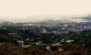
Mbombela, formerly Nelspruit, is a city in northeastern South Africa. It is the capital and the largest city of the Mpumalanga province. Located on the Crocodile River, The city lies about 110 km (68 mi) by road west of the Mozambique border, 330 km (210 mi) east of Johannesburg and 82 km (51 mi) north of the Eswatini border. The city was one of the host cities of the 2010 FIFA World Cup.

The R24 is a major East-West provincial route in the Gauteng and North West provinces that links OR Tambo International Airport with Rustenburg via Johannesburg, Krugersdorp and Magaliesburg. The process of renaming the streets and freeway that form the route from Krugersdorp eastward to OR Tambo International after anti-apartheid stalwart Albertina Sisulu was completed in 2013.

The R25 is a provincial route in South Africa that connects Johannesburg with Groblersdal via Kempton Park, Bapsfontein and Bronkhorstspruit.

The R35 is a provincial route in Mpumalanga, South Africa that connects Amersfoort with Middelburg via Morgenzon and Bethal. The R35 used to connect with the N3 near Ladysmith, but the portion of the road from Amersfoort onwards is now part of the N11.

The R37 is a provincial route in South Africa that connects Polokwane with Mbombela via Burgersfort and Lydenburg (Mashishing).

The R40 is a provincial route in South Africa that connects the Eswatini border at Bulembu via Barberton, Mbombela, Bushbuckridge, Acornhoek and Hoedspruit with Phalaborwa. The route spans two provinces and passes through several private game reserves.
The R104 is a regional route in South Africa that is the designation for some of the old sections of roads that were previously the N4, prior to upgrading. It connects Rustenburg in the North West province with eMalahleni in Mpumalanga province via Mooinooi, Hartbeespoort, Pretoria and Bronkhorstspruit. There are two additional sections in Mpumalanga province: a 50km section connecting Middelburg and Wonderfontein and a 17km section passing through Mbombela.

Seawoods–Darave or simply Seawoods is a newly developed railway station on the Harbour line of the Mumbai Suburban Railway and is a sub-node in Nerul node. The railway station derives its name from the famous Seawoods NRI complex developed by CIDCO especially for high income and economically well to do groups. The area has developed rapidly in recent years compared to any other nodes in Navi Mumbai due to its strategic location, having Vashi, Mumbai & Thane towards its north and Ulwe, Uran, JNPT & upcoming international airport towards is south and CBD Belapur, Kharghar & Panvel towards its east. The station is located adjacent to Sector 40 & 42, few kilometers away from Seawoods NRI complex.

The N4 is a national route in South Africa that runs from Skilpadshek on the Botswana border, past Rustenburg, Pretoria, eMalahleni and Mbombela, to Komatipoort on the Mozambique border. The entire route is a toll road.

The N11 is a national route in South Africa which runs from the Botswana border at Groblersbrug, through Mokopane, Middelburg, Ermelo and Newcastle to end at the N3 just after Ladysmith.
The R101 is a Regional Route in South Africa that is the designation for some of the old sections of roads that were previously the N1, prior to upgrading. It only has 2 sections, from Bellville to Worcester and from Johannesburg to Polokwane.
The R538 is a Regional Route in Mpumalanga, South Africa. The route begins east of Mbombela and passes through White River to connect with Hazyview.
The R544 is a Regional Route in Mpumalanga, South Africa. It connects Bethal with Kwaggafontein via Witbank (eMalahleni) and Verena.
The R555 is a Regional Route in South Africa that connects Springs with Ohrigstad via Delmas, Ogies, Witbank, Middelburg, Stoffberg and Burgersfort.
The M18 road is a long metropolitan route in Gauteng, South Africa. It connects Pretoria with Thembisa via Centurion and Olifantsfontein.
The M22 road is a metropolitan route in the City of Tshwane in Gauteng, South Africa. It connects Pretoria Industrial with Queenswood via Proclamation Hill, Pretoria West, Pretoria CBD and Rietondale.
The M1 road is a short metropolitan route in the City of Tshwane in Gauteng, South Africa. It connects Pretoria West and the Pretoria CBD with Pretoria North via Mayville.
Riverside is a suburb of Mbombela in Mpumalanga, South Africa and is situated 4 km north of the Mbombela CBD. The suburb which is categorised as a City Improvement District (CID) is situated on the western banks of the Crocodile and Nels rivers.
Valencia Park is a suburb of Mbombela in Mpumalanga, South Africa. It is situated on the eastern outskirts of Mbombela and approximately 2 km east of the Mbombela CBD.


