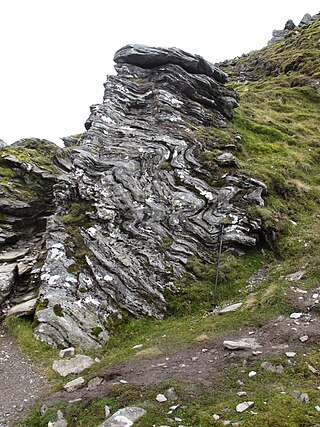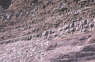
The Moine Thrust Belt or Moine Thrust Zone is a linear tectonic feature in the Scottish Highlands which runs from Loch Eriboll on the north coast 190 kilometres (120 mi) southwest to the Sleat peninsula on the Isle of Skye. The thrust belt consists of a series of thrust faults that branch off the Moine Thrust itself. Topographically, the belt marks a change from rugged, terraced mountains with steep sides sculptured from weathered igneous, sedimentary and metamorphic rocks in the west to an extensive landscape of rolling hills over a metamorphic rock base to the east. Mountains within the belt display complexly folded and faulted layers and the width of the main part of the zone varies up to ten kilometres, although it is significantly wider on Skye.

The Dalradian Supergroup is a stratigraphic unit in the lithostratigraphy of the Grampian Highlands of Scotland and in the north and west of Ireland. The diverse assemblage of rocks which constitute the supergroup extend across Scotland from Islay in the west to Fraserburgh in the east and are confined by the Great Glen Fault to the northwest and the Highland Boundary Fault to the southeast. Much of Shetland east of the Walls Boundary Fault is also formed from Dalradian rocks. Dalradian rocks extend across the north of Ireland from County Antrim in the north east to Clifden on the Atlantic coast, although obscured by younger Palaeogene lavas and tuffs or Carboniferous rocks in large sections.

The Gascoyne Complex is a terrane of Proterozoic granite and metamorphic rock in the central-western part of Western Australia. The complex outcrops at the exposed western end of the Capricorn Orogen, a 1,000 km-long arcuate belt of folded, faulted and metamorphosed rocks between two Archean cratons; the Pilbara craton to the north and the Yilgarn craton to the south. The Gascoyne Complex is thought to record the collision of these two different Archean continental fragments during the Capricorn Orogeny at 1830–1780 Ma.

The Torridon Group is a series of Tonian arenaceous and argillaceous sedimentary rocks, which occur extensively in the Northwest Highlands of Scotland. These strata are particularly well exposed in the district of upper Loch Torridon, a circumstance which suggested the name Torridon Sandstone, first applied to these rocks by James Nicol. Stratigraphically, they lie unconformably on gneisses of the Lewisian complex and sandstones of the lithologically similar Mesoproterozoic Stoer Group and their outcrop extent is restricted to the Hebridean Terrane.

The Lewisian complex or Lewisian gneiss is a suite of Precambrian metamorphic rocks that outcrop in the northwestern part of Scotland, forming part of the Hebridean Terrane and the North Atlantic Craton. These rocks are of Archaean and Paleoproterozoic age, ranging from 3.0–1.7 billion years (Ga). They form the basement on which the Stoer Group, Wester Ross Supergroup and probably the Loch Ness Supergroup sediments were deposited. The Lewisian consists mainly of granitic gneisses with a minor amount of supracrustal rocks. Rocks of the Lewisian complex were caught up in the Caledonian orogeny, appearing in the hanging walls of many of the thrust faults formed during the late stages of this tectonic event.

The Hebridean terrane is one of the terranes that form part of the Caledonian orogenic belt in northwest Scotland. Its boundary with the neighbouring Northern Highland terrane is formed by the Moine Thrust Belt. The basement is formed by Archaean and Paleoproterozoic gneisses of the Lewisian complex, unconformably overlain by the Neoproterozoic Torridonian sediments, which in turn are unconformably overlain by a sequence of Cambro–Ordovician sediments. It formed part of the Laurentian foreland during the Caledonian continental collision.

The Wrekin terrane is one of five inferred fault bounded terranes that make up the basement rocks of the southern United Kingdom. The other notable geological terranes in the region are the Charnwood terrane, Fenland terrane, Cymru terrane and the Monian Composite terrane. The Wrekin terrane is bounded to the west by the Welsh Borderland fault system and to the east by the Malvern lineament. The geological terrane to the west is the Cymru Terrane and to the east is Charnwood Terrane. The majority of rocks in the area are associated with the outcrops that are evident at the faulted boundaries.

The Colonsay Group is an estimated 5,000 m thick sequence of mildly metamorphosed Neoproterozoic sedimentary rocks that outcrop on the islands of Colonsay, Islay and Oronsay and the surrounding seabed. They have been correlated with the Grampian Group, the oldest part of the Dalradian Supergroup.

Pre-collisional Himalaya is the arrangement of the Himalayan rock units before mountain-building processes resulted in the collision of Asia and India. The collision began in the Cenozoic and it is a type locality of a continental-continental collision. The reconstruction of the initial configuration of the rock units and the relationship between them is highly controversial, and major concerns relate to the arrangements of the different rock units in three dimensions. Several models have been advanced to explain the possible arrangements and petrogenesis of the rock units.

The Aravalli Mountain Range is a northeast-southwest trending orogenic belt in the northwest part of India and is part of the Indian Shield that was formed from a series of cratonic collisions. The Aravalli Mountains consist of the Aravalli and Delhi fold belts, and are collectively known as the Aravalli-Delhi orogenic belt. The whole mountain range is about 700 km long. Unlike the much younger Himalayan section nearby, the Aravalli Mountains are believed much older and can be traced back to the Proterozoic Eon. They are arguably the oldest geological feature on Earth. The collision between the Bundelkhand craton and the Marwar craton is believed to be the primary mechanism for the development of the mountain range.
The Badenoch Group is a sequence of metamorphosed Tonian age sedimentary rocks that outcrop across the Central Highlands of Scotland, east of the Great Glen. This rock sequence has formerly been referred to as the Central Highland Migmatite Complex and the Central Highland Division.

The Stoer Group is a sequence of Mesoproterozoic sedimentary rocks that outcrops on the peninsula of Stoer, near Assynt, Sutherland. The dominant lithology is sandstone with breccias and conglomerates developed near the base It is subdivided into three formations. It lies unconformably on the underlying Archaean to Paleoproterozoic age gneisses of the Lewisian complex and is in turn unconformably overlain by the Neoproterozoic Torridon Group.
The Sleat Group, which outcrops on the Sleat peninsula on Skye, underlies the Torridon Group conformably, but the relationship with the Stoer Group is nowhere exposed. It is presumed to have been deposited later than the Stoer Group, but possibly in a separate sub-basin. It is metamorphosed to greenschist facies and sits within the Kishorn Nappe, part of the Caledonian thrust belt, making its exact relationship to the other outcrops difficult to assess. The sequence consists of mainly coarse feldspathic sandstones deposited in a fluvial environment with some less common grey shales, probably deposited in a lacustrine environment.
The geology of Mauritania is built on more than two billion year old Archean crystalline basement rock in the Reguibat Shield of the West African Craton, a section of ancient and stable continental crust. Mobile belts and the large Taoudeni Basin formed and filled with sediments in the connection with the Pan-African orogeny mountain building event 600 million years ago and a subsequent orogeny created the Mauritanide Belt. In the last 251 million years, Mauritania has accumulated additional sedimentary rocks during periods of marine transgression and sea level retreat. The arid country is 50% covered in sand dunes and has extensive mineral resources, although iron plays the most important role in the economy.

The Torridonian is the informal name given to a sequence of Mesoproterozoic to Neoproterozoic sedimentary rocks that outcrop in a strip along the northwestern coast of Scotland and some parts of the Inner Hebrides from the Isle of Mull in the southwest to Cape Wrath in the northeast. They lie unconformably on the Archaean to Paleoproterozoic basement rocks of the Lewisian complex and unconformably beneath the Cambrian to Lower Ordovician rocks of the Ardvreck Group.

The Loch Ness Supergroup is one of the subdivisions of the Neoproterozoic sequence of sedimentary rocks in the Scottish Highlands. It is found everywhere in tectonic contact above the older Wester Ross Supergroup. It is thought to be unconformably overlain by the Cryogenian to Cambrian Dalradian Supergroup.
The Renlandian Orogeny is a Tonian tectonic and metamorphic event that is found in East Greenland, on Svalbard, on Ellesmere Island and in Scotland. It takes its name from Renland in East Greenland, where the event was first recognised.

The Morar Group is a sequence of Tonian sedimentary rocks that have been subjected to a series of tectonic and metamorphic events since their deposition. Originally interpreted to be lowest (oldest) part of a "Moine Supergroup", this sequence now forms part of the Wester Ross Supergroup. They lie unconformably on Archean to Paleoproterozoic basement of the Lewisian complex. The contact with the overlying Glenfinnan Group of the Loch Ness Supergroup is everywhere a tectonic one, formed by the Sgurr Beag Thrust or related structures.

The Moinian or just the Moine, formerly the Moine Supergroup, is a sequence of Neoproterozoic metasediments that outcrop in the Northwest Highlands of Scotland between the Moine Thrust Belt to the northwest and the Great Glen Fault to the southeast and one part of the Grampian Highlands to the southeast of the fault. It takes its name from A' Mhòine, a peat bog in northern Sutherland.

The Port Askaig Tillite Formation (PATF) is a sequence of glacigenic sedimentary rocks deposited during the Cryogenian period of the Neoproterozoic era, forming part of the Dalradian Supergroup. It is exposed along the Dalradian outcrop from Galway, Mayo and Donegal in Ireland in the west through Islay and the Garvellachs in the Inner Hebrides to Schiehallion, Braemar and Fordyce to the east on mainland Scotland. The formation records a time in Earth's history where there were repeated glaciations where ice sheets extended to low latitudes, sometimes referred to as a Snowball Earth.


