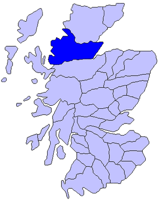
Torridon Group

Last updated

Torridon Group
Stratigraphic range: 1000-960 Ma
Thickness4,000–6,000 m
Lithology
PrimarySandstone
OtherConglomerate, breccia, shale
Location
CountryScotland, United Kingdom
Type section
Named for Loch Torridon
Layers of sandstone of the Diabaig Formation exposed near Diabaig Torridonian Sandstone.jpg
Layers of sandstone of the Diabaig Formation exposed near Diabaig
Slioch formed of Torridon Group sandstones lying on an irregular unconformity over Lewisian gneiss, seen in the middle and foreground around Loch Maree Slioch from Loch Maree.jpg
Slioch formed of Torridon Group sandstones lying on an irregular unconformity over Lewisian gneiss, seen in the middle and foreground around Loch Maree

The Torridon Group is a series of Tonian (lower Neoproterozoic) arenaceous and argillaceous sedimentary rocks, which occur extensively in the Northwest Highlands of Scotland. These strata are particularly well exposed in the district of upper Loch Torridon, a circumstance which suggested the name Torridon Sandstone, first applied to these rocks by James Nicol. [1] Stratigraphically, they lie unconformably on gneisses of the Lewisian complex and sandstones of the lithologically similar Mesoproterozoic Stoer Group and their outcrop extent is restricted to the Hebridean Terrane. [2]

Contents

Lithology

The dominant lithology of the Torridon Group is red and brown sandstone, often arkosic, with subsidiary amounts of shale, particularly towards the top of the sequence, with coarse conglomerates and breccias locally at the base. Some of the materials of these rocks were derived from the underlying Lewisian gneiss, upon the uneven surface of which they rest, but the bulk of the material was sourced from rocks that are nowhere now exposed. Upon this ancient denuded land surface the Torridon Group sequence rests horizontally or with gentle dip. [1] Some of the peaks, such as Beinn Eighe, are capped with white Cambrian quartzite, giving them a distinctive appearance when seen from afar. Some of the quartzite contains fossilized worm burrows and is known as pipe rock, which is approximately 500 million years old. The Torridon Group landscape is itself highly denuded by glacial and alluvial action.

Occurrence

Geological map of the Hebridean Terrane showing distribution of Torridonian sediments Hebridean Terrane.png
Geological map of the Hebridean Terrane showing distribution of Torridonian sediments

Their outcrop extends in a belt of variable breadth from Cape Wrath to the Point of the peninsula of Sleat in Skye, running in a NNESSW direction through Caithness, Sutherland, Ross and Cromarty, and Skye and Lochalsh. They form the isolated mountain peaks of Canisp, Quinag and Suilven in the area of Loch Assynt, of Slioch near Loch Maree, and other hills. They attain their maximum development in the Applecross, Gairloch and Torridon districts, form the greater part of Scalpay, and occur also in Rùm, Raasay, Soay and the Crowlin Islands. [1] They are also found beneath much of the Sea of the Hebrides overlying the Lewisian gneiss. [3]

Sub-divisions

Horizontally bedded sandstones of the Torridon Group, forming the Horns of Beinn Alligin Horns of Alligin.jpg
Horizontally bedded sandstones of the Torridon Group, forming the Horns of Beinn Alligin

The Torridon Group is divided into four formations, the Diabaig, Applecross, Aultbea and Cailleach Head formations. The Torridon Group infills an irregular land surface with up to 600 m of topography locally, cutting down through the previously deposited Stoer group sediments, resting in many areas directly on the Lewisian. It has been suggested that there is significant unconformity within this group, between the Diabaig and Applecross Formations. [4]

Diabaig Formation

The lowest part of this formation consists of a basal breccia containing clasts derived from the underlying Lewisian complex with the thickest developments in the paleovalleys. The breccias pass vertically and laterally into tabular sandstones. These are locally channelised and interfinger with grey shales containing thin beds of fine-grained sandstone with wave rippled surfaces. The shales show the effects of desiccation with mudcracks preserved by being filled by overlying sandstone layers. In the upper part of the formation, beds of massive sandstone with sharp bases appear, becoming more common and thicker bedded towards the top. Ripple-drift lamination at the top of the sandstone layers indicates deposition from easterly-flowing currents. This sequence is interpreted to be to represent the progressive infill of the topography by alluvial fans building out into ephemeral lakes. The more massive beds are interpreted to be lake turbidites. [2]

Applecross Formation

This formation consists of coarse sandstones, both trough and planar cross-bedded. The orientation of the troughs suggest a paleocurrent flowing from the Northwest. The sandstones carry a distinctive set of pebbles, including jasper and porphyry. Most of the sandstone beds are affected by soft-sediment deformation structures suggesting liquefaction, possibly as a result of seismic activity. The uppermost part of the formation consists of finer-grained sandstones, transitional to those of the overlying Aultbea Formation. At Cape Wrath the basal part of the formation shows a fanning of paleocurrent directions consistent with deposition from a large alluvial fan (~40 km radius) with its apex near the Minch Fault. The source area for this fan has been calculated as about 10,000 km2. [2]

Aultbea Formation

Sgurr Fiona and the Corrag Bhuidhe pinnacles on An Teallach Sgurr fiona.jpg
Sgurr Fiona and the Corrag Bhuidhe pinnacles on An Teallach

This formation is similar to the Applecross formation except that the sandstones are fine to medium-grained and there are very few pebbles. Almost all of these sandstone beds show the contortions shown by the older formation. The Applecross and Aultbea Formations together consist of an overall fining-upward sequence of sandstones. Only the outcrops at Cape Wrath described above have a consistent radial pattern suggesting that the sequence was deposited in a bajada environment, by a series of smaller fans merging to form a braided river system. [2]

Cailleach Head Formation

This formation is similar to the underlying Aultbea Formation, the main difference being in grain size, with this formation being noticeably finer-grained. The sequence is made up of 22 m thick cycles, each with a basal erosion surface followed by dark grey shales with desiccation cracks, planar cross-bedded sandstones with wave rippled tops, overlain by trough cross-bedded micaceous sandstones. These cycles are thought to represent repeated progradation of deltas into a lake. A lack of evaporite minerals suggest that the lakes had through drainage. Acritarch microfossils were described from here by Teall in 1907, [5] the first Precambrian fossils described in Britain. [2]

Age

The upper age limit for the deposition of this sequence is constrained by the age of the last tectonic and metamorphic event to affect the Lewisian complex and the depositional age of the Stoer Group on which it was deposited, for which ages cluster between about 12001100 Ma. The lower limit is provided by the age of the lower Cambrian quartzite that lies above it, about 544 Ma. Radiometric ages from the basal part of the Torridon Group sequence itself give ages of about 1000950 Ma. This implies an age gap of at least 200 Ma between the deposition of the Stoer and Torridon groups, consistent with the paleomagnetic evidence of a major break. [2] Ages of detrital zircons also provide some constraints on the sequence age. The lower part of the Sleat Group show ages consistent with derivation from Scourian and to a lesser extent Laxfordian rocks, with no dates after 1700 Ma. The upper part of the Sleat Group includes a large component of broadly Laxfordian age with almost no Archaean ages, with a lower limit of about 1200 Ma. In contrast the Diabaig Formation shows a small group clustered around 1100 Ma, the age of the Grenville Orogeny. In the Applecross and Aultbea Formations there are many more zircons giving ages around 1100 Ma and even below 1000 Ma.

Depositional setting

Variations in thickness and lithology in the Sleat and Torridon Groups were interpreted as reflecting deposition in a rift setting. Evidence from seismic reflection data in the Minch suggests that the Minch Fault was active throughout the deposition of the Torridon Group. This is consistent with the generally westerly derived pebbly material throughout the thickness of the Applecross Formation, suggesting a constantly rejuvenated sediment source in that direction. [2] More recent work has suggested that although the Sleat Group was probably deposited in a rift setting, the scale and continuity of the Torridon Group, particularly the Applecross and Aultbea Formations, is more consistent with a molasse type setting possibly related to the Grenville Orogeny, within a foreland basin. [4]

See also

Related Research Articles

<span class="mw-page-title-main">Ross, Scotland</span> Traditional region of Scotland

Ross is a region of Scotland. One of the provinces of Scotland from the 9th century, it gave its name to a later earldom and to the counties of Ross-shire and, later, Ross and Cromarty. The name Ross allegedly derives from a Gaelic word meaning "headland", perhaps a reference to the Black Isle. Another possible origin is the West Norse word for Orkney – Hrossey – meaning horse island; the area once belonged to the Norwegian earldom of Orkney. Ross is a historical comital region, perhaps predating the Mormaerdom of Ross. It is also a region used by the Kirk, with the Presbytery of Ross being part of the Synod of Ross, Sutherland and Caithness.

<span class="mw-page-title-main">Liathach</span> Mountain in Highland, Scotland, UK

Liathach is a mountain in the Torridon Hills, in the Northwest Highlands of Scotland. It stands between Loch Torridon and the neighbouring mountain Beinn Eighe. The mountain is a ridge running east–west, with several peaks, and its upper half is made up of many steep rocky terraces. The highest peak is the Munro of Spidean a' Choire Lèith at 1,055 metres (3,461 ft) high. The other Munro peak is Mullach an Rathain at 1,024 metres (3,360 ft) high.

<span class="mw-page-title-main">Torridon Hills</span>

The Torridon Hills surround Torridon village in the Northwest Highlands of Scotland. The name is usually applied to the mountains to the north of Glen Torridon. They are among the most dramatic and spectacular peaks in the British Isles and made of some of the oldest rocks in the world. Many are over 3,000 feet high, so are considered Munros.

<span class="mw-page-title-main">Moine Thrust Belt</span> Fault in Highland, Scotland, UK

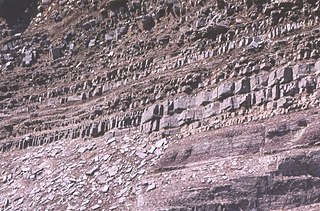
The Moine Thrust Belt or Moine Thrust Zone is a linear tectonic feature in the Scottish Highlands which runs from Loch Eriboll on the north coast 190 kilometres (120 mi) south-west to the Sleat peninsula on the Isle of Skye. The thrust belt consists of a series of thrust faults that branch off the Moine Thrust itself. Topographically, the belt marks a change from rugged, terraced mountains with steep sides sculptured from weathered igneous, sedimentary and metamorphic rocks in the west to an extensive landscape of rolling hills over a metamorphic rock base to the east. Mountains within the belt display complexly folded and faulted layers and the width of the main part of the zone varies up to 10 kilometres (6.2 mi), although it is significantly wider on Skye.

The Northwest Highlands are located in the northern third of Scotland that is separated from the Grampian Mountains by the Great Glen. The region comprises Wester Ross, Assynt, Sutherland and part of Caithness. The Caledonian Canal, which extends from Loch Linnhe in the south-west, via Loch Ness to the Moray Firth in the north-east splits this area from the rest of the country. The city of Inverness and the town of Fort William serve as gateways to the region from the south.

<span class="mw-page-title-main">Stac Fada Member</span>

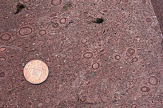
The Stac Fada Member is a distinctive layer towards the top of the Mesoproterozoic Bay of Stoer Formation, part of the Stoer Group in northwest Scotland. This rock unit is generally 10 to 15 metres thick and is made of sandstone that contains accretionary lapilli and many dark green glassy fragments of mafic composition.

<span class="mw-page-title-main">Lewisian complex</span> Suite of Precambrian metamorphic rocks that outcrop in the northwestern part of Scotland

The Lewisian complex or Lewisian gneiss is a suite of Precambrian metamorphic rocks that outcrop in the northwestern part of Scotland, forming part of the Hebridean Terrane and the North Atlantic Craton. These rocks are of Archaean and Paleoproterozoic age, ranging from 3.0–1.7 billion years (Ga). They form the basement on which the Stoer Group, Wester Ross Supergroup and probably the Loch Ness Supergroup sediments were deposited. The Lewisian consists mainly of granitic gneisses with a minor amount of supracrustal rocks. Rocks of the Lewisian complex were caught up in the Caledonian orogeny, appearing in the hanging walls of many of the thrust faults formed during the late stages of this tectonic event.

<span class="mw-page-title-main">Hebridean Terrane</span> Part of the Caledonian orogenic belt in northwest Scotland

The Hebridean Terrane is one of the terranes that form part of the Caledonian orogenic belt in northwest Scotland. Its boundary with the neighbouring Northern Highland Terrane is formed by the Moine Thrust Belt. The basement is formed by Archaean and Paleoproterozoic gneisses of the Lewisian complex, unconformably overlain by the Neoproterozoic Torridonian sediments, which in turn are unconformably overlain by a sequence of Cambro–Ordovician sediments. It formed part of the Laurentian foreland during the Caledonian continental collision.

<span class="mw-page-title-main">Unkar Group</span> Sequence of geologic strata of Proterozoic age

The Unkar Group is a sequence of strata of Proterozoic age that are subdivided into five geologic formations and exposed within the Grand Canyon, Arizona, Southwestern United States. The Unkar Group is the basal formation of the Grand Canyon Supergroup. The Unkar is about 1,600 to 2,200 m thick and composed, in ascending order, of the Bass Formation, Hakatai Shale, Shinumo Quartzite, Dox Formation, and Cardenas Basalt. The Cardenas Basalt and Dox Formation are found mostly in the eastern region of Grand Canyon. The Shinumo Quartzite, Hakatai Shale, and Bass Formation are found in central Grand Canyon. The Unkar Group accumulated approximately between 1250 and 1104 Ma. In ascending order, the Unkar Group is overlain by the Nankoweap Formation, about 113 to 150 m thick; the Chuar Group, about 1,900 m (6,200 ft) thick; and the Sixtymile Formation, about 60 m (200 ft) thick. These are all of the units of the Grand Canyon Supergroup. The Unkar Group makes up approximately half of the thickness of the Grand Canyon Supergroup.

<span class="mw-page-title-main">Bass Formation</span> Lithostratigraphic unit found in Arizona, US

The Bass Formation, also known as the Bass Limestone, is a Mesoproterozoic rock formation that outcrops in the eastern Grand Canyon, Coconino County, Arizona. The Bass Formation erodes as either cliffs or stair-stepped cliffs. In the case of the stair-stepped topography, resistant dolomite layers form risers and argillite layers form steep treads. In general, the Bass Formation in the Grand Canyon region and associated strata of the Unkar Group-rocks dip northeast (10°–30°) toward normal faults that dip 60+° toward the southwest. This can be seen at the Palisades fault in the eastern part of the main Unkar Group outcrop area. In addition, thick, prominent, and dark-colored basaltic sills intrude across the Bass Formation.

<span class="mw-page-title-main">Shinumo Quartzite</span> Mesoproterozoic rock formation in the Grand Canyon, Arizona

The Shinumo Quartzite also known as the Shinumo Sandstone, is a Mesoproterozoic rock formation, which outcrops in the eastern Grand Canyon, Coconino County, Arizona,. It is the 3rd member of the 5-unit Unkar Group. The Shinumo Quartzite consists of a series of massive, cliff-forming sandstones and sedimentary quartzites. Its cliffs contrast sharply with the stair-stepped topography of typically brightly-colored strata of the underlying slope-forming Hakatai Shale. Overlying the Shinumo, dark green to black, fissile, slope-forming shales of the Dox Formation create a well-defined notch. It and other formations of the Unkar Group occur as isolated fault-bound remnants along the main stem of the Colorado River and its tributaries in Grand Canyon.

Typically, the Shinumo Quartzite and associated strata of the Unkar Group dip northeast (10°–30°) toward normal faults that dip 60+° toward the southwest. This can be seen at the Palisades fault in the eastern part of the main Unkar Group outcrop area.

<span class="mw-page-title-main">Geology of the Isle of Skye</span>

The geology of the Isle of Skye in Scotland is highly varied and the island's landscape reflects changes in the underlying nature of the rocks. A wide range of rock types are exposed on the island, sedimentary, metamorphic and igneous, ranging in age from the Archaean through to the Quaternary.

<span class="mw-page-title-main">Dox Formation</span> Landform in the Grand Canyon, Arizona

The Dox Formation, also known as the Dox Sandstone, is a Mesoproterozoic rock formation that outcrops in the eastern Grand Canyon, Coconino County, Arizona. The Dox Formation comprises the bulk of the Unkar Group, the older subdivision of the Grand Canyon Supergroup. The Unkar Group is about 1,600 to 2,200 m thick and composed of, in ascending order, the Bass Formation, Hakatai Shale, Shinumo Quartzite, Dox Formation, and Cardenas Basalt. The Unkar Group is overlain in ascending order by the Nankoweap Formation, about 113 to 150 m thick; the Chuar Group, about 1,900 m (6,200 ft) thick; and the Sixtymile Formation, about 60 m (200 ft) thick. The entire Grand Canyon Supergroup overlies deeply eroded granites, gneisses, pegmatites, and schists that comprise Vishnu Basement Rocks.

<span class="mw-page-title-main">Sixtymile Formation</span> Cambrian geologic formation found in Grand Canyon, Arizona

The Sixtymile Formation is a very thin accumulation of sandstone, siltstone, and breccia underlying the Tapeats Sandstone that is exposed in only four places in the Chuar Valley. These exposures occur atop Nankoweap Butte and within Awatubi and Sixtymile Canyons in the eastern Grand Canyon, Arizona. The maximum preserved thickness of the Sixtymile Formation is about 60 m (200 ft). The actual depositional thickness of the Sixtymile Formation is unknown owing to erosion prior to deposition of the Tapeats Sandstone.

<span class="mw-page-title-main">Stoer Group</span>

The Stoer Group is a sequence of Mesoproterozoic sedimentary rocks that outcrops on the peninsula of Stoer, near Assynt, Sutherland. The dominant lithology is sandstone with breccias and conglomerates developed near the base It is subdivided into three formations. It lies unconformably on the underlying Archaean to Paleoproterozoic age gneisses of the Lewisian complex and is in turn unconformably overlain by the Neoproterozoic Torridon Group.

The Sleat Group, which outcrops on the Sleat peninsula on Skye, underlies the Torridon Group conformably, but the relationship with the Stoer Group is nowhere exposed. It is presumed to have been deposited later than the Stoer Group, but possibly in a separate sub-basin. It is metamorphosed to greenschist facies and sits within the Kishorn Nappe, part of the Caledonian thrust belt, making its exact relationship to the other outcrops difficult to assess. The sequence consists of mainly coarse feldspathic sandstones deposited in a fluvial environment with some less common grey shales, probably deposited in a lacustrine environment.

<span class="mw-page-title-main">Torridonian</span> Sequence of rocks in Scotland

The Torridonian is the informal name given to a sequence of Mesoproterozoic to Neoproterozoic sedimentary rocks that outcrop in a strip along the northwestern coast of Scotland and some parts of the Inner Hebrides from the Isle of Mull in the southwest to Cape Wrath in the northeast. They lie unconformably on the Archaean to Paleoproterozoic basement rocks of the Lewisian complex and unconformably beneath the Cambrian to Lower Ordovician rocks of the Ardvreck Group.

<span class="mw-page-title-main">Loch Ness Supergroup</span>

The Loch Ness Supergroup is one of the subdivisions of the Neoproterozoic sequence of sedimentary rocks in the Scottish Highlands. It is found everywhere in tectonic contact above the older Wester Ross Supergroup. It is thought to be unconformably overlain by the Cryogenian to Cambrian Dalradian Supergroup.

<span class="mw-page-title-main">Wester Ross Supergroup</span>

The Wester Ross Supergroup is one of the subdivisions of the Neoproterozoic sequence of sedimentary rocks in the Scottish Highlands. It lies unconformably on medium to high-grade metamorphic rocks and associated igneous rocks of the Archaean and Paleoproterozoic age Lewisian complex or locally over the Mesoproterozoic sedimentary rocks of the Stoer Group. The contact between the Wester Ross Supergroup and the next youngest of the Neoproterozoic sequences in the Scottish Highlands, the Loch Ness Supergroup, is everywhere a tectonic one.

<span class="mw-page-title-main">Morar Group</span>

The Morar Group is a sequence of Tonian sedimentary rocks that have been subjected to a series of tectonic and metamorphic events since their deposition. Originally interpreted to be lowest (oldest) part of a "Moine Supergroup", this sequence now forms part of the Wester Ross Supergroup. They lie unconformably on Archean to Paleoproterozoic basement of the Lewisian complex. The contact with the overlying Glenfinnan Group of the Loch Ness Supergroup is everywhere a tectonic one, formed by the Sgurr Beag Thrust or related structures.

References

  1. 1 2 3 Wikisource-logo.svg One or more of the preceding sentences incorporates text from a publication now in the public domain : Howe, John Allen (1911). "Torridonian". In Chisholm, Hugh (ed.). Encyclopædia Britannica . Vol. 27 (11th ed.). Cambridge University Press. p. 62.
  2. 1 2 3 4 5 6 7 Park, R.G.; Stewart, A.D.; Wright, D.T. (2003). "3. The Hebridean terrane". In Trewin N.H. (ed.). The Geology of Scotland. London: Geological Society. pp. 45–61. ISBN   978-1-86239-126-0 . Retrieved 23 June 2010.
  3. C.Michael Hogan, (2011) Sea of the Hebrides. Eds. P. Saundry & C.J.Cleveland. Encyclopedia of Earth. National Council for Science and the Environment. Washington DC.
  4. 1 2 Kinnaird, T.C.; Prave A.R.; Kirkland C.L.; Horstwood M.; Parrish R.; Batchelor R.A.B. (2007). "The late Mesoproterozoic–early Neoproterozoic tectonostratigraphic evolution of NW Scotland: the Torridonian revisited". Journal of the Geological Society. 164 (3): 541–551. doi:10.1144/0016-76492005-096. S2CID   132423577.
  5. Peach, B.N.; Horne, J.; Gunn, W.; Clough C.T.; Hinxman L.W.; Teall J.J.H. (1907). The Geological Structure of the NW Highlands of Scotland. Memoirs. Geological Survey of Great Britain. p. 668.