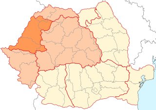
With an area of 238,397 km2 (92,046 sq mi), Romania is the twelfth-largest country in Europe. It is a country located at the crossroads of Eastern and Southeast Europe. It's bordered on the Black Sea, the country is halfway between the equator and the North Pole and equidistant from the westernmost part of Europe—the Atlantic Coast—and the most easterly—the Ural Mountains. Romania has 3,195 kilometres (1,985 mi) of border. Moldova and Ukraine lie to the east, Bulgaria to the south, and Serbia and Hungary to the west by the Pannonian Plain. In the southeast, 245 kilometres (152 mi) of sea coastline provide an important outlet to the Black Sea and the Atlantic Ocean.

Transylvania is a historical and cultural region in Central Europe, encompassing central Romania. To the east and south its natural border is the Carpathian Mountains and to the west the Apuseni Mountains. Broader definitions of Transylvania also include the western and northwestern Romanian regions of Crișana and Maramureș, and occasionally Banat. Historical Transylvania also includes small parts of neighbouring Western Moldavia and even a small part of south-western neighbouring Bukovina to its north east.

The Carpathian Mountains or Carpathians are a range of mountains forming an arc across Central Europe and Southeast Europe. Roughly 1,500 km (930 mi) long, it is the third-longest European mountain range after the Urals at 2,500 km (1,600 mi) and the Scandinavian Mountains at 1,700 km (1,100 mi). The range stretches from the far eastern Czech Republic (3%) and Austria (1%) in the northwest through Slovakia (21%), Poland (10%), Ukraine (10%), Romania (50%) to Serbia (5%) in the south. The highest range within the Carpathians is known as the Tatra Mountains in Poland and Slovakia, where the highest peaks exceed 2,600 m (8,500 ft). The second-highest range is the Southern Carpathians in Romania, where the highest peaks range between 2,500 m (8,200 ft) and 2,550 m (8,370 ft).

Caraș-Severin is a county (județ) of Romania on the border with Serbia. The majority of its territory lies within the historical region of Banat, with a few northeastern villages considered part of Transylvania. The county seat is Reșița. The Caraș-Severin county is part of the Danube–Criș–Mureș–Tisa Euroregion.

Timiș is a county (județ) of western Romania on the border with Hungary and Serbia, in the historical region of Banat, with the county seat at Timișoara. It is the westernmost and the largest county in Romania in terms of land area. The county is also part of the Danube–Criș–Mureș–Tisa Euroregion.

Arad County is an administrative division (județ) of Romania roughly translated into county in the western part of the country on the border with Hungary, mostly in the region of Crișana and few villages in Banat. The administrative center of the county lies in the city of Arad. The Arad County is part of the Danube–Criș–Mureș–Tisa Euroregion.

Banat is a geographical and historical region located in the Pannonian Basin that straddles Central and Eastern Europe. It is divided among three countries: the eastern part lies in western Romania ; the western part of Banat is in northeastern Serbia ; and a small northern part lies within southeastern Hungary.

Crișana is a geographical and historical region in north-western Romania, named after the Criș (Körös) River and its three tributaries: the Crișul Alb, Crișul Negru, and Crișul Repede. In Romania, the term is sometimes extended to include areas beyond the border, in Hungary; in this interpretation, the region is bounded to the east by the Apuseni Mountains, to the south by the Mureș River, to the north by the Someș River, and to the west by the Tisza River, the Romanian-Hungarian border cutting it in two. However, in Hungary, the area between the Tisza River and the Romanian border is usually known as Tiszántúl.

Sânnicolau Mare is a town in Timiș County, Romania, and the westernmost in the country. Located in the Banat region, along the borders with Serbia and Hungary, it has a population of 10,627 as of 2021.

Krassó-Szörény was an administrative county (comitatus) of the historic Kingdom of Hungary. Its territory is now mostly located in south-western Romania, with one very small part which is located in Serbia. The capital of the county was Lugos.

County of Temes was an administrative county (comitatus) of the Kingdom of Hungary. Its territory is now in southwestern Romania and northeastern Serbia. The capital of the county was Temesvár, which also served as the kingdom's capital between 1315–1323.

Torontál was an administrative county (comitatus) of the Kingdom of Hungary. Its territory is now divided between Serbia and Romania, except for a small area which is part of Hungary. The capital of the county was Nagybecskerek, the current Zrenjanin.

The Southern Carpathians are a group of mountain ranges located in southern Romania. They cover the part of the Carpathian Mountains located between the Prahova River in the east and the Timiș and Cerna Rivers in the west. To the south they are bounded by the Balkan mountain range in eastern Serbia.

The Pannonian Basin or Carpathian Basin is a large sedimentary basin situated in southeast Central Europe. After the Treaty of Trianon following World War I, the geomorphological term Pannonian Plain became more widely used for roughly the same region, referring to the lowlands in the area occupied by the Pannonian Sea during the Pliocene Epoch.

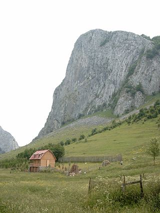
The Apuseni Mountains is a mountain range in Transylvania, Romania, which belongs to the Western Romanian Carpathians. The highest peak is the Bihor Peak at 1,849 metres (6,066 ft). The Apuseni Mountains have about 400 caves.

Glad was the ruler of Banat at the time of the Hungarian conquest of the Carpathian Basin around 900 AD, according to the Gesta Hungarorum. The Gesta, which was written by an author known in modern scholarship as Anonymus in the second half of the 12th century or in the early 13th century, is the earliest extant Hungarian chronicle. The Gesta did not refer to the enemies of the conquering Hungarians, who had been mentioned in earlier annals and chronicles, but wrote of a dozen persons, including Glad, who are unknown from other primary sources of the Hungarian Conquest. Therefore, modern historians debate whether Glad was an actual enemy of the conquerors or only a "fictitious person" made up by Anonymus. In Romanian historiography, based on the mention by Anonymus some 300 years later, Glad is described as one of the three Romanian dukes who ruled a historical region of present-day Romania in the early 10th century.

Divisions of the Carpathians are a categorization of the Carpathian mountains system.

The Prehistory of Transylvania describes what can be learned about the region known as Transylvania through archaeology, anthropology, comparative linguistics and other allied sciences.

The Banat Mountains are a number of mountain ranges in Romania, considered part of the Western Romanian Carpathians mountain range.

Cornești-Iarcuri is the largest known Bronze Age fortress in Europe, located in the immediate vicinity of the modern village of Cornești, between the Romanian cities of Arad and Timișoara. Covering an area of 17.65 km2, the site encompasses the remains of four enclosing rings of earthen ramparts, wooden palisades and moats. The settlement served as an important commercial and military center in the Bronze Age. As of 2020, there are plans to inscribe the site in the World Heritage List.


