
The River Wharfe is a river in Yorkshire, England originating within the Yorkshire Dales National Park. For much of its middle course it is the county boundary between West Yorkshire and North Yorkshire. Its valley is known as Wharfedale.

Wharfedale is the valley of the upper parts of the River Wharfe and one of the Yorkshire Dales. It is situated in North Yorkshire, and the cities of Leeds and Bradford in West Yorkshire. It is the upper valley of the River Wharfe. Towns and villages in Wharfedale include Buckden, Kettlewell, Conistone, Grassington, Hebden, Bolton Abbey, Addingham, Ilkley, Burley-in-Wharfedale, Otley, Pool-in-Wharfedale, Arthington, Collingham and Wetherby. Beyond Wetherby, the valley opens out and becomes part of the Vale of York.

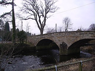
Kettlewell is a village in Upper Wharfedale, North Yorkshire, England. Historically part of the West Riding of Yorkshire, it lies 6 miles (10 km) north of Grassington, at the point where Wharfedale is joined by a minor road which leads north-east from the village over Park Rash Pass to Coverdale. Great Whernside rises to the east. The population of the civil parish was 322 at the 2011 census, with an estimated population of 340 in 2015.

The River Dibb, also known as Barben Beck, is a small river located in North Yorkshire, England. It is a tributary of the River Wharfe. Grimwith Reservoir is at the head of the River Dibb at a point some 2.5 miles (4 km) from Appletreewick. The river flows for 5.2 kilometres (3.2 mi), and must maintain a flow of 273,000 cubic metres (9,600,000 cu ft) of water a day into the River Wharfe system.

Austwick is a village and civil parish in the Craven district of North Yorkshire, England, about 5 miles (8 km) north-west of Settle. The village is on the edge of the Yorkshire Dales National Park.

Barden is a civil parish in the Craven district of North Yorkshire, England. It consists of the hamlet of Drebley and a few scattered houses in Wharfedale in the Yorkshire Dales. The parish also includes two areas of moorland, Barden Fell to the east of the River Wharfe and Barden Moor to the west of the river. Both moorlands are access land, and are popular with walkers. Barden Fell rises to the prominent peak of Simon's Seat, and Barden Moor includes two scenic 19th century reservoirs. Much of the parish is on the Bolton Abbey estate.

Buckden is a village and civil parish in the Craven district of North Yorkshire, England. Historically part of the West Riding of Yorkshire, Buckden is situated in the Yorkshire Dales National Park, and on the east bank of the River Wharfe in Wharfedale. The civil parish includes the hamlet of Cray and the whole of Langstrothdale. According to the 2011 Census the parish had a population of 187.
Tholthorpe is a village and civil parish in the Hambleton district of North Yorkshire, England. It is situated approximately 4 miles (6 km) south-west of Easingwold and 12 miles (19 km) north-west of York.
Foxup is a hamlet in the Yorkshire Dales in the Craven district of North Yorkshire, England. The hamlet is near Halton Gill and Litton and is 13 miles (21 km) north west of Grassington. Foxup is in the civil parish of Halton Gill.
River Skirfare is a small river in North Yorkshire, England, that flows through Littondale and ends where it joins the larger River Wharfe. The source is the confluence of Foxup Beck and Cosh Beck at the hamlet of Foxup.
Oughtershaw is a hamlet in the Yorkshire Dales, North Yorkshire, England. It lies on a road it shares with other small villages; Deepdale, Yockenthwaite and Hubberholme, which traverses the watershed between Upper Wharfedale\Langstrothdale and Wensleydale over Fleet Moss into Gayle. The hamlet lies at 1,180 feet (360 m) above sea level. The name is first recorded in 1241 as Huctredsdale, and stems from Uhtred's copse, a personal name. It has had many spellings down the years, being known variously as Ughtershaw, Ughtirshey, Owghtershawe, and Outershaw in the 19th century.
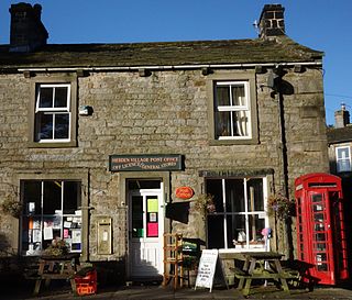
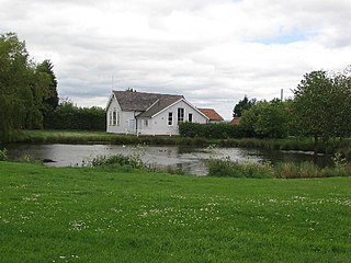
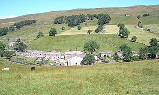
Hebden is a village and civil parish in the Craven District of North Yorkshire, England, and one of four villages in the ecclesiastical parish of Linton. It lies near Grimwith Reservoir and Grassington, in Wharfedale in the Yorkshire Dales National Park. In 2011 it had a population of 246.
The River Wenning is a tributary of the River Lune, flowing through North Yorkshire and Lancashire. The name derives from the Old English Wann, meaning dark river.

Beckermonds is a small hamlet in the Craven district of North Yorkshire, England. The hamlet lies at the western end of Langstrothdale, at the confluence of Green Field Beck and Oughtershaw Beck, which join to form the start of the River Wharfe.
Kettlewell with Starbotton is a civil parish in the Craven district of North Yorkshire, England.

Healaugh is a village and civil parish in the Selby District of North Yorkshire, England. According to the 2001 census it had a population of 161 in 63 households. The population had increased to 249 at the 2011 census. The village is about three miles north north-east of Tadcaster.

Skyreholme is a hamlet in Wharfedale in the Yorkshire Dales, North Yorkshire, England. It lies 1-mile (1.6 km) east of Appletreewick, in the small side valleys formed by Skyreholme Beck and Blands Beck, which meet in the hamlet to form Fir Beck, a short tributary of the River Wharfe. Parcevall Hall is at the north end of the hamlet, and Skyreholme Beck flows through the limestone gorge of Trollers Gill just to the north.

Crummackdale,, is a small valley north of the village of Austwick in the Craven District of North Yorkshire, England. The Valley is drained by Austwick Beck, which flows into the River Wenning, which in turn heads westwards to empty into the Irish Sea. Crummackdale is a narrow south west facing dale, at the south west corner of the Yorkshire Dales National Park.
The geology of the Yorkshire Dales National Park in northern England largely consists of a sequence of sedimentary rocks of Ordovician to Permian age. The core area of the Yorkshire Dales is formed from a layer-cake of limestones, sandstones and mudstones laid down during the Carboniferous period. It is noted for its karst landscape which includes extensive areas of limestone pavement and large numbers of caves including Britain's longest cave network.

