White Mountain Airport (New Hampshire)

Last updated
White Mountain Airport (Defunct)
Summary
Elevation  AMSL 495 ft / 151 m
Coordinates 44°01′21″N71°06′41″W / 44.02250°N 71.11139°W / 44.02250; -71.11139
Runways
Direction LengthSurface
ftm
2,940896 Asphalt

White Mountain Airport was a private airport located in North Conway, in Carroll County, New Hampshire, United States. This general aviation airport had one runway.

Contents

The airport closed in the late 1980s. The property has since become the site of Settlers' Green Outlet Village and hotel, as well as the proposed site for the middle segment of the Conway Bypass.

History

In 1921, the Carroll County Park Association procured approximately 140 acres (57 ha) of land in a series of purchases. The property included a grandstand and racing track that had hosted horse racing and motorcycle racing over the years, as well as providing a fairgrounds and a site for early regional aerial barnstorming. There was also a dance hall.

In October 1929 the association sold the land to the White Mountain Airport Corporation for $4,100. When the corporation was formed, the buildings on the property were sold and the airport developers tore down the grandstand and stalls.

Ralph P. Newhall and his brother-in-law Walter J. Maguire (an agent for the Shell Eastern Petroleum Corporation) started the Eagle Flying Service on the property in 1930. The Conway Village Airport was a second airfield just a few miles away. During his years as part of the New England Air Circus Association, Wylie Apte participated in several air shows at both the Conway Village and White Mountain airports and was known to the Airport Corporation. When Newhall and Maguire sought to extricate themselves from the flying business, they persuaded Apte to take over the operation on a year-to-year lease arrangement working on a percentage basis. [1] [2] Prior to this, Apte was a founder of the New England Air Circus Association with Lee Bowman. He had also been manager at Parlin Field and Twin Mountain airports.

In 1934, Apte accepted their offer and became the manager of the airport operations at the White Mountain Airport. He persuaded the White Mountain Airport Corporation to clear away the trees so that he could taxi near the highway, and in 1935 a WPA project cleared off the stumps and enlarged the runway to 1,500 feet (460 m).

When the US entered World War II in December 1941 following the bombing of Pearl Harbor, Apte closed the White Mountain Airport operation and joined the Coastal Air Patrol as a 1st Lieutenant Pilot. When he returned from his WWII service, he presented the White Mountain Airport Corporation with a proposal to sell him the property. The Airport Corporation was dissolved May 4, 1943, and sold the property to Apte in July 1943, who had by that time acquired 101 of the original 108 shares.

Wylie Apte, Sr. died in August 1970. Following his death, his son Wylie (Bunky) Apte, Jr. assumed control of the White Mountain Airport. By the mid-1970s Bunky had made the airport into a busy tourist attraction with a fleet of five Waco UPF-7 open cockpit bi-planes, a helicopter, sailplane, and several Piper and Cessna aircraft providing scenic rides and charter flights. Because sightseeing rides are highly seasonal, Wylie sought support and partnership from the Town of Conway in the late 1970s. By the 1980s the area of North Conway had substantially changed, with many new commercial businesses moving to the area. This resulted in a significant overhaul of property taxes which made it impossible to make the airport a financial success. Wylie Apte sold the property to developers who established the Settlers' Green Outlet Village on the site in 1988. [3]

Search and rescue

The airport and Wylie Apte, Sr. played a role in several search and rescue efforts over the years, flying missions for the forest fire patrol, lost persons, drowning accidents, hospital patients, and the Northeast airline tragedy. Some of the more notable early search and rescue efforts from the White Mountain Airport included the following:

In June 1933, Joseph Simon, a young man from Brookline, Massachusetts, was lost while hiking with friends to the Lakes of the Clouds on Mount Washington. The group had not prepared themselves with food or supplies appropriate for the hike and were separated as the weather turned bad. Apte conducted an aerial search for Simon, flying low over the wooded terrain in dangerous air currents over Mount Washington for two days. Ultimately, Simon was found, but had died due to exposure.

In October 1941, five-year-old Pamela Hollingsworth, daughter of a prominent Lowell, Massachusetts, businessman, was lost in the woods near Albany, New Hampshire, and Mount Chocorua, setting off a kidnapping scare and massive eight-day search involving hundreds of searchers. Apte and several other pilots from the White Mountain Airport flew searches to help locate the girl. When she was found she said that she had heard the airplanes' motors but was unable to signal the planes due to the density of the forest.

In August 1952 Charlotte Cook from Windham Center, Connecticut, disappeared in the White Mountain National Forest. Apte and two other pilots from the White Mountain Airport flew several search flights low over the search area communicating with ground search parties via radio.

Airport improvements

Hard-surface runway: The general aviation industry was pressed for airstrips just as the auto industry pressed for roads. By the 1960s it was clear that improved access should be provided as more modern light aircraft were not suited to grass landings. The project involved the construction of a hard surfaced black top runway, 3,000 feet (910 m) long and 60 feet (18 m) wide, to handle all single-engine and the majority of multi-engine business and corporate aircraft. Alvin Coleman and Son did the construction, assisted by an airport engineer from the NH State Aeronautics Commission. At the south end of the runway they hauled in 10 loads of sand and removed the cabins along with the old blue spruce. The cost was under $7000, financed in part by Mr. Apte and by contributions from local businessmen and interested persons. Materials were provided at cost. The new runway was dedicated July 30, 1961. John Poor from North Conway was the Master of Ceremonies. William T. Piper from Piper Aircraft Corporation, Lock Haven, Pennsylvania, was guest speaker. More than 60 planes flew into North Conway for the dedication ceremonies. FAA officials and Russell Hilliard, NH Aeronautics Commission Director, spoke.

Paved taxiway, ramp, fuel system: In the late 1960s a paved taxiway from the runway to the hangar area was put in. Wylie Jr. assumed control of the airport following the death of Wylie Sr. in 1970 and put in a paved ramp, paved taxiways, up to date fuel system, and an office complex.

New hangar: In the fall of 1952, the airport's hangar burned down. A new hangar was dedicated in 1963. It was constructed by Harold J. Coles utilizing prefabricated trusses that were trucked in. In the early 1970s, Wylie Jr. built a modern maintenance hangar and additional hangar space for 30 resident planes.

Plowing for winter use: Until the 1970s, the airport was seasonal and not open in the winter. After the runway, taxiway, and ramp were paved, it was possible to plow and make the airport available for winter use. Parker Morton designed and used a prototype for plowing the airport.

Fly-ins, air shows

As manager at the White Mountain Airport, Apte organized and participated in many air shows starting in the 1930s. These meets included air races, rides, and thrilling aerial stunts performed by New England's early aviators, including:

For an air show in 1935, the Radio Club set up air-to-ground radio to allow passengers in the airplanes to talk to the people on the ground during their flight.

In 1963 the airport hosted a Fly-In for the annual meeting of the Aviation Association of NH in support of a joint project by the North Conway Chamber of Commerce, the Eastern Slope Jaycees, and the Eastern Slope Ski Club. [4]

Soaring

In 1938, Lew Barringer made what is generally recognized as the first sailplane wave flight in North America. At the time, he and others were exploring ridge conditions in the east central area of New Hampshire, when he found himself on top of the clouds just west of North Conway Airport. This was evidently a wave off the Moat Mountains and is worthy of mention due to its proximity to the airport. It took 28 years before another wave flight was made in the area, when in October 1966 a small group successfully explored the major wave system 20 miles (32 km) to the north in the lee of Mount Washington. [5]

Related Research Articles

<span class="mw-page-title-main">Laughlin/Bullhead International Airport</span> Airport in Mohave County, Arizona

Laughlin/Bullhead International Airport is a public use airport located 1.15 miles north of the central business district of Bullhead City, in Mohave County, Arizona, United States. It is owned by Mohave County. The airport is across the Colorado River and one block away from Laughlin, Nevada. Many of the rooms at Laughlin's casino-hotels offer a view of the airport. It was named 2011 Airport of the Year by the Arizona Department of Transportation.

<span class="mw-page-title-main">Linden Airport</span> Airport

Linden Airport is a mile southeast of downtown Linden, in Union County, New Jersey. Also known as Linden Municipal Airport, it is next to U.S. Route 1&9. The National Plan of Integrated Airport Systems for 2011–2015 categorized it as a general aviation reliever airport.

<span class="mw-page-title-main">Hillsboro Airport</span> Airport in Hillsboro, Oregon

Hillsboro Airport, also known as Portland–Hillsboro Airport, is a corporate, general aviation and flight-training airport serving the city of Hillsboro, in Washington County, Oregon, United States. It is one of three airports in the Portland, Oregon, metropolitan area owned and operated by the Port of Portland. Established in 1928, it is Oregon's second busiest airport at over 200,000 operations annually.

<span class="mw-page-title-main">Adirondack Regional Airport</span> Public-use airport in Harrietstown, New York, USA

Adirondack Regional Airport is a public use airport located four nautical miles northwest of the central business district of Saranac Lake, in Franklin County, New York, United States. The airport is owned by the Town of Harrietstown and is situated in the north-central Adirondacks two miles (3 km) from Lake Clear. It is served by one commercial airline, subsidized by the Essential Air Service program.
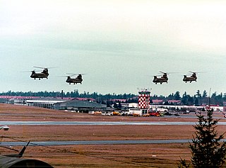
<span class="mw-page-title-main">Lincoln Airport (Nebraska)</span> Public airport and military airbase serving Lincoln, Nebraska, USA

Lincoln Airport is a public/military airport five miles (8.0 km) northwest of downtown Lincoln, the state capital, in Lancaster County, Nebraska, United States. It is owned by the Lincoln Airport Authority and is the second-largest airport in Nebraska. It is included in the Federal Aviation Administration (FAA) National Plan of Integrated Airport Systems for 2023–2027 in which it is categorized as a non-hub primary commercial service facility. It has four gates with jetways, to be, as of February 2022, expanded to six.

<span class="mw-page-title-main">Manchester–Boston Regional Airport</span> Public airport in Manchester and Londonderry, New Hampshire, United States

Manchester–Boston Regional Airport, commonly referred to as Manchester Airport, is a public use airport 3 miles (5 km) south of the central business district of Manchester, New Hampshire, United States on the border of Hillsborough and Rockingham counties. It is owned by the City of Manchester, and is in the southern part of the city on the border with Londonderry, New Hampshire.

<span class="mw-page-title-main">Crystal Airport (Minnesota)</span> Airport in Crystal, Minnesota

Crystal Airport is a public airport named after the city of Crystal in Hennepin County, Minnesota, United States. Most of the airport is in the city of Crystal. Portions north of taxiway C are in Brooklyn Park, and the north east corner of the airport is in Brooklyn Center. It is eight miles (13 km) northwest of the central business district of Minneapolis and is owned by the Metropolitan Airports Commission. The airport covers an area of approximately 430 acres.

<span class="mw-page-title-main">Brackett Field</span> Airport in California, United States

Brackett Field is a public airport a mile (2 km) southwest of La Verne, in Los Angeles County, California, United States. It was named after astronomer Frank Parkhurst Brackett (1865–1951).

<span class="mw-page-title-main">Waterbury–Oxford Airport</span> Airport in Oxford, Connecticut

Waterbury–Oxford Airport, also known as Oxford Airport, is a public airport located three miles (5 km) north of the central business district of Oxford, a town in New Haven County, Connecticut, United States.

<span class="mw-page-title-main">Mason Jewett Field</span> Airport

Mason Jewett Field is a public use airport located one nautical mile (1.85 km) southeast of the central business district of Mason, in Ingham County, Michigan, United States. It is owned and operated by the Capital Region Airport Authority, which also oversees the nearby Capital Region International Airport (LAN) in Lansing, Michigan.

<span class="mw-page-title-main">Sacramento Executive Airport</span> Airport in Sacramento, California

Sacramento Executive Airport is a public airport three miles (5 km) south of downtown Sacramento, in Sacramento County, California, United States. The airport covers 540 acres (219 ha) and has two lit runways and a helipad.

<span class="mw-page-title-main">Nashua Airport</span> Airport

Nashua Airport at Boire Field is a public-use airport located three nautical miles (6 km) northwest of the central business district of Nashua, a city in Hillsborough County, New Hampshire, United States. Owned by the Nashua Airport Authority, It is included in the Federal Aviation Administration (FAA) National Plan of Integrated Airport Systems for 2017–2021, in which it is categorized as a national reliever airport facility.

<span class="mw-page-title-main">Schaumburg Regional Airport</span> Airport in Schaumburg, IL, US

Schaumburg Regional Airport is a public use airport located 22 nautical miles northwest of Chicago in the village of Schaumburg in Cook and DuPage counties, Illinois, United States. The airport is owned by the Village of Schaumburg and is just south of the Schaumburg Municipal Helistop.

<span class="mw-page-title-main">Lebanon-Warren County Airport</span> Airport in Lebanon, Ohio

<span class="mw-page-title-main">Seaside Municipal Airport</span> Airport in Seaside, Oregon

Seaside Municipal Airport is a general aviation airport located one mile (1.6 km) Northeast of Seaside in Clatsop County, Oregon, United States. It is owned and operated as a public airport by the city of Seaside. The airport has one asphalt runway, a parallel taxiway, a parking apron with space for up to 20 aircraft, and a five-bay hangar building. Seaside Municipal is the closest airport to Seaside, Gearhart, and Cannon Beach.

<span class="mw-page-title-main">Stevens Field</span> Airport

Stevens Field is a public-use, general aviation airport located three miles northwest of the central business district of Pagosa Springs in Archuleta County, Colorado, United States. It is publicly owned by Archuleta County. It has no air traffic control tower or commercial passenger services, but it does have a fixed base operator (FBO), and it is popular among light sport and general aviation aircraft doing cross country flights, where the airport serves as an GA-friendly waypoint, refueling stop, and pilot rest/sleep opportunity. Its address is 61 Aviation Ct, Pagosa Springs, CO.

<span class="mw-page-title-main">Joseph A. Hardy Connellsville Airport</span> Airport in Fayette County, Pennsylvania

Joseph A. Hardy Connellsville Airport is a public-use airport located four nautical miles southwest of Connellsville in Dunbar Township, Fayette County, Pennsylvania, United States. It is owned by the Fayette County Airport Authority and serves the south-eastern segment of the Pittsburgh metropolitan area. The airport serves the general aviation community with no scheduled commercial airline service.

<span class="mw-page-title-main">Continental Airlines Flight 1883</span> 2006 aviation incident

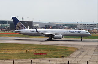
Continental Airlines Flight 1883 was a Boeing 757 that mistakenly landed on a taxiway at Newark Liberty International Airport on the evening of October 28, 2006. There were no reported injuries or damage, but the narrowly averted disaster was investigated by the National Transportation Safety Board, and caused the Federal Aviation Administration to reevaluate and modify air and ground safety procedures at and around Newark Airport.

<span class="mw-page-title-main">Settlers Green</span> Outlet shopping center in North Conway, New Hampshire, United States

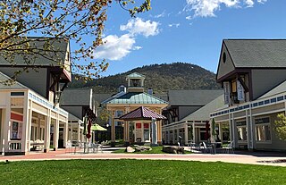
Settlers Green is an outlet shopping center in North Conway, New Hampshire, United States. The center was built on the location of the former White Mountain Airport and opened in February 1988. It has since expanded to a former industrial site and a former competing shopping center. Settlers Green is divided into four parts: the Outlet Village, which contains mostly outlet stores; Settlers Crossing, which has a combination of lifestyle and specialty retailers; Settlers Corner, which houses a Staples, Home Depot, and HomeGoods; and Streetside, which features upscale retailers. With over 500,000 square feet (46,000 m2) of retail space, it is the largest shopping center in the White Mountains Region.

References

  1. Unidentified newspaper, n.d.: "Air Meet at the Conways: October 12 and 13, at Conway; October 14 at White Mt. Airport"
  2. Unidentified newspaper (most likely The Reporter), no date (1934?), "White Mt. Airport Flying Activities in North Conway and Conway in Charge of Pilot Wylie Apt"
  3. Prevost, Lisa (November 27, 1988). "NORTHEAST NOTEBOOK; North Conway, N.H.: A New Resort Within a Resort". The New York Times . Retrieved April 14, 2022.
  4. Manchester Union Leader, Sept. 23, 1963; Photo
  5. Guy Gosselin, "A Timeless Sky", 1938 Soaring Association Publication, Feb. 1968, p. 12