Mount Gibbs is located in the Sierra Nevada of the U.S. state of California, 2.6 miles (4 km) south of Mount Dana. The mountain was named in honor of Oliver Gibbs, a professor at Harvard University and friend of Josiah Whitney. The summit marks the boundary between Yosemite National Park and the Ansel Adams Wilderness, and Mount Gibbs is the sixth-highest mountain, of Yosemite.

Sentinel Dome is a granite dome in Yosemite National Park, United States. It lies on the south wall of Yosemite Valley, 0.8 miles (1.3 km) southwest of Glacier Point and 1.4 miles (2.3 km) northeast of Profile Cliff.

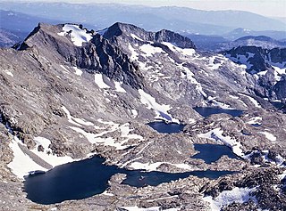
Mount Lyell is the highest point in Yosemite National Park, at 13,114 feet (3,997 m). It is located at the southeast end of the Cathedral Range, 1+1⁄4 miles northwest of Rodgers Peak. The peak as well as nearby Lyell Canyon is named after Charles Lyell, a well-known 19th century geologist. The peak had one of the last remaining glaciers in Yosemite, Lyell Glacier. The Lyell Glacier is currently considered to be a permanent ice field, not a living glacier. Mount Lyell divides the Tuolumne River watershed to the north, the Merced to the west, and the Rush Creek drainage in the Mono Lake Basin to the southeast.
Dix Mountain is a mountain in the Dix Range of the Adirondacks in the U.S. state of New York. With an elevation of 4,857 feet (1,480 m), it is the sixth-highest peak in New York and one of the 46 Adirondack High Peaks. It is located roughly on the boundary between the towns of North Hudson and Keene in Essex County, and in the High Peaks Wilderness Area of Adirondack Park. The crest of the peak consists of a very narrow ridge, which continues to the southeast and rises to a subsidiary peak named Beckhorn, then continues south to other peaks of the Dix Range. The summit is also in an alpine zone above the treeline. The ridge offers unobstructed views of Elk Lake to the southwest, the Great Range to the northwest, and Lake Champlain and the Green Mountains to the east.

Clouds Rest is a mountain in Yosemite National Park, located east-northeast of Yosemite Village, California. Although there are many peaks in the park having far greater elevation, the proximity of Clouds Rest to the valley gives it a very high degree of visual prominence.

Mount Hoffmann is a prominent peak in northeastern Mariposa County in the center of Yosemite National Park, California, United States. It rises above May Lake and is a day hike of 6.2 miles (10.0 km) (one-way) from Tioga Pass Road. The mountain is named for the cartographer Charles F. Hoffmann, who was part of the California Geological Survey of the Sierra Nevada.

Mount Maclure is the nearest neighbor to Mount Lyell, the highest point in Yosemite National Park. Mount Maclure is the fifth-highest mountain of Yosemite. Mount Maclure is located at the southeast end of the Cathedral Range, about 0.6 miles (0.97 km) northwest of Lyell. The summit is on the boundary between Madera and Tuolumne counties which is also the boundary between the park and the Ansel Adams Wilderness. It was named in honor of William Maclure, a pioneer in American geology who produced the first geological maps of the United States. Maclure Glacier, one of the last remaining glaciers in Yosemite, is situated on the mountain's northern flank.

Fairview Dome is a prominent granite dome in Yosemite National Park, located 1.8 miles (2.9 km) north of Cathedral Peak and 4 miles (6.4 km) west of Tuolumne Meadows. Near Fairview Dome is Marmot Dome, linked by an area called Razor Back. Northwest is Hammer Dome.
Electra Peak is a mountain, broadly in the Tuolumne Meadows area of Yosemite National Park, if far, from the road. Electra Peak is the 14th highest mountain in Yosemite National Park.

Virginia Peak is a mountain summit in the northern part of Yosemite National Park, north of Tuolumne Meadows. It is the 25th-highest mountain in Yosemite National Park.

Gray Peak is an 11,573-foot-elevation mountain summit located in the Sierra Nevada mountain range, in Madera County of northern California, United States. It is situated in Yosemite National Park, approximately 9 miles (14 km) southeast of Yosemite Valley, 1.3 mile (2.1 km) north of Red Peak, and 1.5 mile (2.4 km) south-southeast of Mount Clark. Gray Peak is the fourth-highest peak in the Clark Range, which is a subset of the Sierra Nevada.

Red Peak is an 11,699-foot-elevation (3,566 meter) mountain summit located in the Sierra Nevada mountain range, in Madera County of northern California, United States. It is situated in Yosemite National Park, approximately 10.5 miles (16.9 km) southeast of Yosemite Valley, 1.5 mile (2.4 km) south-southeast of Gray Peak, and 1.5 mile (2.4 km) northwest of Merced Peak, the nearest higher neighbor. Red Peak is the second-highest peak in the Clark Range, which is a subset of the Sierra Nevada. This geographical feature's brilliant color is caused by iron-bearing minerals weathered to an iron rust which colors the granite.

Vandever Mountain is an 11,947-foot-elevation (3,641-meter) mountain summit located in the Sierra Nevada mountain range, in Tulare County of northern California. It is situated on the shared boundary of Sequoia National Park with Sequoia National Forest, four miles south of Mineral King, and 1.78 miles (2.86 km) west of Florence Peak, the nearest higher neighbor. Vandever Mountain ranks as the 439th highest summit in California. Topographic relief is significant as the south aspect rises 2,000 feet above White Chief Canyon in one mile. The summit can be reached via class 2 hiking from Farewell Gap or White Chief Canyon.

Stanton Peak is a granitic mountain with a summit elevation of 11,695 feet (3,565 m) located in the Sierra Nevada mountain range, in Tuolumne County of northern California, United States. The remote summit is set within Yosemite National Park, and is situated 0.63 mile southwest of line parent Virginia Peak, 1.6 mile southeast of Whorl Mountain, and 2.6 miles south-southeast of Matterhorn Peak. Stanton Peak is bound on the west by Spiller Creek and on the east by Return Creek, so precipitation runoff from this mountain drains into these two tributaries of the Tuolumne River. Topographic relief is significant as the summit rises over 2,100 feet above Spiller Creek in one mile.
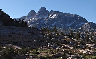
Finger Peaks is a granitic mountain summit with an elevation of 11,498 feet (3,505 m) located in the Sierra Nevada mountain range, in northern California, United States. The three peaks are situated in Yosemite National Park and Tuolumne County. The landform is set immediately west of Burro Pass, 1.5 mile south of Eocene Peak, and 1.4 mile southwest of Matterhorn Peak. Topographic relief is significant as the summit rises 1,700 feet above Piute Creek in one-half mile. The first ascent of the summit was made July 19, 1931, by Jules Eichorn, Glen Dawson, and Walter Brem. This landform's toponym has been in publications since at least 1925, and was officially adopted by the U.S. Board on Geographic Names in 1932.

Mount Lewis is a 12,350-foot-elevation mountain summit located along the crest of the Sierra Nevada mountain range, in Mono County of northern California, United States. It is situated in the Ansel Adams Wilderness, on land managed by Inyo National Forest. The summit lies less than one mile outside of Yosemite National Park's eastern boundary, and some of the lower western slope lies within the park. The mountain rises 1.8 miles (2.9 km) southeast of Mono Pass, 1.5 miles (2.4 km) northeast of Parker Pass, and two miles north of Parker Peak, which is the nearest higher neighbor. Topographic relief is significant as it rises over 5,200 feet above Grant Lake in four miles which makes the mountain visible from Highway 395.
Rafferty Peak is an 11,110-foot-elevation mountain summit located in Yosemite National Park, in California, United States. It is situated on the common border shared by Mariposa and Tuolumne Counties. It is set south of Tuolumne Meadows in the Cathedral Range which is a sub-range of the Sierra Nevada mountain range. The mountain rises one mile (1.6 km) northwest of Tuolumne Pass, 1.4 mile south of Johnson Peak, and 2.5 miles east of Matthes Crest. Tuolumne Pass is the low point of the saddle between Rafferty Peak and Fletcher Peak. Topographic relief is significant as the summit rises 1,500 feet above Nelson Lake in one mile.

Fletcher Peak is an 11,410-foot-elevation (3,478 meter) mountain summit located in Yosemite National Park, in Mariposa County, California, United States. It is situated south of Tuolumne Meadows in the Cathedral Range which is a sub-range of the Sierra Nevada mountain range. The mountain rises one mile (1.6 km) south of Tuolumne Pass, 1.3 miles (2.1 km) northeast of proximate parent Vogelsang Peak and 1.8 miles (2.9 km) northwest of line parent Parsons Peak. Topographic relief is significant as the summit rises 1,250 feet above Fletcher Lake in 0.38 miles (0.61 km). Precipitation runoff from this landform drains south to the Merced River via Fletcher Creek.

Gale Peak is a 10,690-foot-elevation (3,258 meter) mountain summit located in Madera County, California, United States. It is situated in the Sierra Nevada mountain range, in the southeast corner of Yosemite National Park, on the common boundary which the park shares with the Ansel Adams Wilderness. The mountain rises 1.3 miles (2.1 km) south of Fernandez Pass, 4.5 miles (7.2 km) south of the Clark Range, and 2.2 miles (3.5 km) north-northwest of Madera Peak. Precipitation runoff from this landform drains west into tributaries of the South Fork Merced River, and east into tributaries of the San Joaquin River. Topographic relief is significant as the summit rises 1,400 feet above Upper Chain Lake in 0.38 miles (0.61 km). The peak can be climbed via the class 2 northwest ridge which separates Breeze Lake from the Chain Lakes.
Forsyth Peak is an 11,177-foot-elevation (3,407 meter) mountain summit located in Tuolumne County, California, United States.