
Arcen en Velden is a former town and former municipality in the southeastern Netherlands, now part of the municipality and city of Venlo. It is situated in the province of Limburg.

West Flanders is the westernmost province of the Flemish Region, in Belgium. It is the only coastal Belgian province, facing the North Sea to the northwest. It has land borders with the Dutch province of Zeeland to the northeast, the Flemish province of East Flanders to the east, the Walloon province of Hainaut in the southeast and the French department of Nord to the west. Its capital is Bruges (Brugge). Other important cities are Kortrijk in the south and Ostend (Oostende) on the coast, Roeselare and Ypres (Ieper). The province has an area of 3,197 km2 (1,234 sq mi) which is divided into eight administrative districts (arrondissementen) containing 64 municipalities. As of January 2019, West Flanders has a population of 1,195,796.

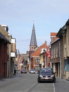
Torhout is a municipality located in the Belgian province of West Flanders. The municipality comprises the city of Torhout proper, the villages of Wijnendale and Sint-Henricus, and the hamlet of De Driekoningen. On January 1, 2012, Torhout had a total population of 20,149. The total area is 45.23 km² which gives a population density of 445 inhabitants per km².
Koekelare is a municipality located in the Belgian province of West Flanders. The municipality comprises the towns of Bovekerke, Koekelare proper and Zande. On 1 January 2006 Koekelare had a total population of 8,291. The total area is 39.19 km² which gives a population density of 212 inhabitants per km².

Werchter is a small village in Belgium which has been part of the municipality of Rotselaar since 1 January 1977. It is the site of Rock Werchter and the birthplace of the painters Cornelius Van Leemputten and Frans Van Leemputten. The origin of the Werchter's name is unknown, but is thought to be related to water.
Eernegem is a town in the Ichtegem municipality, in the province of West Flanders in Belgium.

Westmalle Castle is located in the village of Westmalle, which is part of the municipality of Malle in the Campine region of Flanders, Belgium. Westmalle Castle is situated at an elevation of 29 meters.

The Arrondissement of Bruges is one of the eight administrative arrondissements in the Province of West Flanders, Belgium.
The Arrondissement of Torhout was a short-lived arrondissement in present-day Belgium. It was created out of the Arrondissement of Bruges in 1818, and it already ceased to exist in 1823.

Wijnendale Castle is a historic residence in Wijnendale, West Flanders in Belgium which was once a medieval castle. The present buildings largely date to a nineteenth century restoration, though parts of the north wing still date to the fifteenth century. One wing is currently inhabited by the present owners of the castle, while another is open to the public as a museum.
Grahamdale is a rural municipality in the province of Manitoba in Western Canada. It was incorporated as a Local Government District (LGD) on 1 January 1945, and became a Rural Municipality in 1997.

The European route E 403 is a European route connecting the Belgian towns of Zeebrugge and Tournai. This north-south route runs entirely on Belgian territory and falls together with the Belgian roads N31 and A17.

Ziółkowo is a village in the administrative district of Gmina Gostyń, within Gostyń County, Greater Poland Voivodeship, in west-central Poland. It lies approximately 7 kilometres (4 mi) south-east of Gostyń and 65 km (40 mi) south of the regional capital Poznań.
Odcinek is a village in the administrative district of Gmina Rudniki, within Olesno County, Opole Voivodeship, in south-western Poland. It lies approximately 4 kilometres (2 mi) north-west of Rudniki, 24 km (15 mi) north-east of Olesno, and 63 km (39 mi) north-east of the regional capital Opole.

Laarne Castle is a Belgian moated castle in Laarne, located in the Province of East-Flanders, near its capital city of Ghent. Laarne Castle is situated at an elevation of 3 meters.

Vogelsanck Castle is a moated castle in Zolder in the municipality of Heusden-Zolder, province of Limburg, Belgium.

Orašac is a village in the municipality of Leskovac, Serbia. According to the 2002 census, the village has a population of 582 people.

Dekutince is a village in the municipality of Vladičin Han, Serbia. According to the 2002 census, the village has a population of 271.
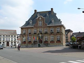
The City Hall of Torhout was the residence of the mayor and the bench of aldermen during their meetings up until the completion of the new City Hall in 2014. It is located on the market in the center of Torhout, West Flanders, Belgium.
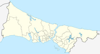
Hüseyin Rahmi Gürpınar Museum is a historic house museum dedicated to the writer Hüseyin Rahmi Gürpınar in İstanbul, Turkey.

