Zonnebeke

Last updated • 3 min readFrom Wikipedia, The Free Encyclopedia
Zonnebeke
Zonnebeke - Town hall 1.jpg
Zonnebeke town hall
Zonnebeke vlag.svg
Zonnebeke wapen.svg
Location of Zonnebeke
Zonnebeke
Belgium location map.svg
Red pog.svg
Zonnebeke
Location in Belgium
Location of Zonnebeke in West Flanders
Zonnebeke West-Flanders Belgium Map.svg
Coordinates: 50°52′N02°59′E / 50.867°N 2.983°E / 50.867; 2.983
CountryFlag of Belgium (civil).svg  Belgium
Community Flemish Community
Region Flemish Region
Province West Flanders
Arrondissement Ypres
Government
  MayorDirk Sioen (INSPRAAK)
  Governing party/iesINSPRAAK, CD&V
Area
  Total68.09 km2 (26.29 sq mi)
Population
 (2018-01-01) [1]
  Total12,445
  Density180/km2 (470/sq mi)
Postal codes
8980
NIS code
33037
Area codes 051/057
Website www.zonnebeke.be

Zonnebeke (Dutch pronunciation: [ˈzɔnəˌbeːkə] ; West Flemish : Zunnebeke) is a municipality located in the Belgian province of West Flanders. The municipality comprises the villages of Beselare  [ nl ], Gheluvelt  [ nl ], Passendale, Zandvoorde and Zonnebeke proper. On January 1, 2006, Zonnebeke had a total population of 11,758. The total area is 67.57 km2 which gives a population density of 174 inhabitants per km2.

Contents

History

Destruction of Zonnebeke, 1918 Destruction on the Western Front 1914-1918 Q12282.jpg
Destruction of Zonnebeke, 1918

The villages of Zonnebeke congregated around a large Augustinian abbey and its associated Benedictine convent in Nonnebosschen. Both were destroyed during the iconoclastic outbreak in 1580. Only the abbey was rebuilt, but was looted during the French occupation the abbey was confiscated. Passendale played a role in the Battle of Westrozebeke in 1382.

Situated in the centre of the Ypres Salient, World War I destroyed the whole area. Left abandoned until the early 1920s, people slowly returned and rebuilt the villages. In 1932, the locals opened a cheese making facility, which to this day is the only source of Passendale cheese. [2]

Another battle during World War II during the Allied advance across Europe, where Passendale was used in a defensive operations by the Nazis, did little damage.

Today, Zonnebeke has returned to its long-time balance between agriculture, small business and work in the neighbouring towns. Its major industry is the brickworks in the village of Zonnebeke itself, which extracts the local blue clay.

Zonnebeke underground

Zonnebeke Church Dugout constructed by 171st Tunnelling Company in 1918 (model) Memorial Museum Passchendaele 1917 - Zonnebeke Church Dugout model.jpg
Zonnebeke Church Dugout constructed by 171st Tunnelling Company in 1918 (model)

The village and district of Zonnebeke and its five villages have the largest concentration of underground constructions from World War I, being located at the centre of the Third Battle of Ypres/Battle of Passchendaele. The blue-clay is now being extracted for commercial purposes by the Terca Zonnebeke N.V. brickworks factory, meaning that the structures are now regularly found as the brickworks expands its commercial extraction activities. [3]

About 180 dugout sites have been located in the Ypres Salient and in the 1990s some of them were entered, at least in part. [4]

In 1983, the Australian-built Bremen Redoubt was discovered at the rear of the Zonnebeke brickworks. Opened to the public until 1998, it is believed that its eventual collapse was due to drying support timbers. [5]

During archaeological excavations of the Augustinian abbey, another dugout was discovered under Zonnebeke church. Today the outline of this dugout is marked in an archaeological garden within the church grounds, and a model of the church dugout can be seen at the "Memorial Museum Passchendaele 1917" in Zonnebeke. [6]

On February 21, 1998, a farmer's wife disappeared into the ground while washing the windows. Beecham dugout was subsequently discovered less than 400 metres (1,300 ft) from Tyne Cot Cemetery. [3]

It was made public in spring 2006 that the brickworks had received a licence for the extension of its blue-clay extraction zone. The Association for Battlefield Archaeology and Conservation, using maps compiled of 350 underground structures under the management of Belgian archaeologist Johan Vandewalle and British TV producer Peter Barton, showed that at least one structure was near to the proposed development zone, believed to be the Vampire dugout, [7] which had been rediscovered in 2007. Following discussion with local preservation, historic, council and state officials, the ABAC was allowed to start a scientific research project. They engaged the Centre for Battlefield Archaeology at Glasgow University to provide archaeological support (in light of the residence of the Highland Light Infantry). [7]

Towns

The municipality comprises the villages of Zonnebeke proper, Beselare  [ nl ], Gheluvelt  [ nl ], Passendale and Zandvoorde. All are "deelgemeentes", meaning they were independent municipalities before the merger in the 1970s.

#NameArea
(km2)
Population
(01/01/2014)
IZonnebeke16,554.472
II Beselare  [ nl ]14,332.684
III Gheluvelt  [ nl ]7,791.553
IV Passendale 22,223.152
V Zandvoorde 6,68521

[8]

See also

Related Research Articles

<span class="mw-page-title-main">Battle of Passchendaele</span> 1917 campaign of the First World War

The Third Battle of Ypres, also known as the Battle of Passchendaele, was a campaign of the First World War, fought by the Allies against the German Empire. The battle took place on the Western Front, from July to November 1917, for control of the ridges south and east of the Belgian city of Ypres in West Flanders, as part of a strategy decided by the Allies at conferences in November 1916 and May 1917. Passchendaele lies on the last ridge east of Ypres, 5 mi (8 km) from Roulers, a junction of the Bruges-(Brugge)-to-Kortrijk railway. The station at Roulers was on the main supply route of the German 4th Army. Once Passchendaele Ridge had been captured, the Allied advance was to continue to a line from Thourout to Couckelaere (Koekelare).

<span class="mw-page-title-main">Staden</span> Municipality in Flemish Community, Belgium

Staden is a village and rural municipality in the Belgian province of West Flanders. The municipality has around 11 000 inhabitants.

<span class="mw-page-title-main">Ypres</span> City in West Flanders, Belgium

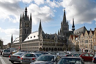
Ypres is a Belgian city and municipality in the province of West Flanders. Though the Dutch name Ieper is the official one, the city's French name Ypres is most commonly used in English. The municipality comprises the city of Ypres/Ieper and the villages of Boezinge, Brielen, Dikkebus, Elverdinge, Hollebeke, Sint-Jan, Vlamertinge, Voormezele, Zillebeke, and Zuidschote. Together, they are home to about 34,900 inhabitants.

<span class="mw-page-title-main">Tyne Cot</span> WWI CWGC cemetery near Passendale, Belgium

Tyne Cot Commonwealth War Graves Cemetery and Memorial to the Missing is a Commonwealth War Graves Commission (CWGC) burial ground for the dead of the First World War in the Ypres Salient on the Western Front. It is the largest cemetery for Commonwealth forces in the world, for any war. The cemetery and its surrounding memorial are located outside Passendale, near Zonnebeke in Belgium.

The Ypres Salient, around Ypres, in Belgium, was the scene of several battles and a major part of the Western Front during World War I.

<span class="mw-page-title-main">Passchendaele Canadian Memorial</span>

The Passchendaele Canadian Memorial is a Canadian war memorial that commemorates the actions of the Canadian Corps in the Second Battle of Passchendaele of World War I. The memorial is located on the former site of Crest Farm, an objective captured by the 4th Canadian Division during the assault of 30 October 1917.

Polygon Wood is a forest located between Ypres and Zonnebeke, West Flanders, Belgium. It was the scene for several battles during the First World War and there are at least two cemeteries of the Commonwealth War Graves Commission in the immediate vicinity of the wood.

<span class="mw-page-title-main">Zillebeke</span> Village in West Flanders, Belgium

Zillebeke is a village in the Flemish province of West Flanders in Belgium. It is a former municipality which is now part of Ypres.

<span class="mw-page-title-main">Battle of Polygon Wood</span> 1917 battle of the First World War

The Battle of Polygon Wood took place from 26 September to 3 October 1917, during the second phase of the Third Battle of Ypres in the First World War. The battle was fought near Ypres in Belgium, in the area from the Menin road to Polygon Wood and thence north, to the area beyond St Julien. Much of the woodland had been destroyed by the huge quantity of shellfire from both sides since 16 July and the area had changed hands several times.

<span class="mw-page-title-main">Passendale</span> Deelgemeente in West Flanders, Belgium

Passendale or Passchendaele is a rural Belgian village in the Zonnebeke municipality of West Flanders province. It is close to the town of Ypres, situated on the hill ridge separating the historical wetlands of the Yser and Leie valleys. It is also commonly known as a battlefield and the name of a campaign during World War I, the Battle of Passchendaele.

Peter Arthur Barton is a British military historian, author and filmmaker specialising in trench warfare during World War I. He has published extensively on military mining and aspects of battlefield archaeology on the Western Front, and led archaeological excavations that have been featured in several Time Team episodes. His work has led to the rediscovery of many tunnels, wartime panoramas and mass graves of soldiers.

<span class="mw-page-title-main">Second Battle of Passchendaele</span> Part of the Third Battle of Ypres in the First World War

The Second Battle of Passchendaele was the culminating attack during the Third Battle of Ypres of the First World War. The battle took place in the Ypres Salient area of the Western Front, in and around the Belgian village of Passchendaele, between 26 October and 10 November 1917. The Canadian Corps relieved the exhausted II Anzac Corps, continuing the advance started with the First Battle of Passchendaele and ultimately capturing the village. Beyond gaining favourable observation positions, the battle was intended to gain drier winter positions on higher ground.

<span class="mw-page-title-main">Boezinge</span> Village in West Flanders, Belgium

Boezinge is a village in the municipality of Ypres in the Belgian province of West Flanders. Boezinge can be reached via the N369 road in the direction of Diksmuide. It was an independent municipality until 1977.

The Vampire dugout, is a First World War underground shelter located near the Belgian village of Zonnebeke. It was created as a British brigade headquarters in early 1918 by the 171st Tunnelling Company of the Royal Engineers after the Third Battle of Ypres/Battle of Passchendaele.

<i>The Menin Road</i> (painting) 1919 painting by Paul Nash

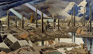
The Menin Road is a large oil painting by Paul Nash completed in 1919 that depicts a First World War battlefield. Nash was commissioned by the British War Memorials Committee to paint a battlefield scene for the proposed national Hall of Remembrance. The painting is considered one of the most iconic images of the First World War and is held by the Imperial War Museum.

<span class="mw-page-title-main">Hooge in World War I</span>

In World War I, the area around Hooge on Bellewaerde Ridge, about 2.5 mi (4 km) east of Ypres in Flanders in Belgium, was one of the easternmost sectors of the Ypres Salient and was the site of much fighting between German and Allied forces.

<span class="mw-page-title-main">171st Tunnelling Company</span> Military unit

The 171st Tunnelling Company was one of the tunnelling companies of the Royal Engineers created by the British Army during World War I. The tunnelling units were occupied in offensive and defensive mining involving the placing and maintaining of mines under enemy lines, as well as other underground work such as the construction of deep dugouts for troop accommodation, the digging of subways, saps, cable trenches and underground chambers for signals and medical services.

<span class="mw-page-title-main">Memorial Museum Passchendaele 1917</span> Belgian museum about the Battle of Passchendaele

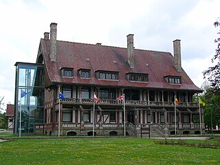
The Passchendaele Museum in Zonnebeke, Belgium, is a museum devoted to the Battle of Passchendaele in 1917. In this battle in only 100 days, almost 500,000 men were killed to gain only eight kilometres of ground.

<span class="mw-page-title-main">Night action of 1/2 December 1917</span>

The Night action of 1/2 December 1917 during the First World War, was a local operation on the Western Front, in Belgium at the Ypres Salient. The action was a British Fourth Army attack on the German 4th Army. The Third Battle of Ypres proper had ended officially on 20 November but the attack was intended to capture the heads of valleys leading eastwards from the ridge, to gain observation over German positions.

References

  1. "Wettelijke Bevolking per gemeente op 1 januari 2018". Statbel. Retrieved 9 March 2019.
  2. Deoudekaasmakerij.be
  3. 1 2 "Memorial Museum Passchendaele 1917". GreatWar.co.uk. Retrieved 2010-06-22.
  4. Activities of The Diggers - Restoration of the Yorkshire Trench & Dug-out, access date 10 July 2015
  5. "Bremen Redoubt". flanderland.de. Retrieved 2010-06-22.
  6. Zonnebeke Church Dugout wordt niet toegankelijk voor publiek, 04/11/2010, access date 9 July 2015
  7. 1 2 "Vampire Dugout" (PDF). polygonwood.com. Retrieved 2010-06-22.
  8. "Gemeente Zonnebeke" (PDF).