Wirksworth is a market town in the Derbyshire Dales district of Derbyshire, England. Its population of 4,904 in the 2021 census was estimated at 5,220 in 2023. Wirksworth contains the source of the River Ecclesbourne. The town was granted a market charter by Edward I in 1306 and still holds a market on Tuesdays in the Memorial Gardens. The parish church of St Mary's is thought to date from 653. The town developed as a centre for lead mining and stone quarrying. Many lead mines were owned by the Gell family of nearby Hopton Hall.

Oxleas Wood is one of the few remaining areas of ancient deciduous forest in Eltham in the Royal Borough of Greenwich, in southeast London. Some parts date back over 8,000 years to the end of the last ice age, the Younger Dryas. It is part of a larger continuous area of woodland and parkland on the south side of Shooter's Hill: other parts are Jack Wood, Castle Wood, Oxleas Meadows, Falconwood Field, Eltham Common and Eltham Park North. Eltham Park North includes the ancient Shepherdleas Wood.
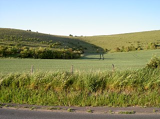
Scratchbury & Cotley Hills SSSI is a 53.5 hectare biological Site of Special Scientific Interest at Norton Bavant in Wiltshire, England, notified in 1951. The Iron Age hillfort of Scratchbury Camp occupies the summit of the hill.

Winkelbury Hill is a 62.95 hectare biological Site of Special Scientific Interest in Berwick St John parish, south-west Wiltshire, England. The site is on the southern flank of the Ebble valley and was notified in 1971 for its herb-rich unimproved chalk grassland, which has some nationally scarce plants and butterflies.

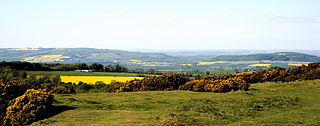
Long Knoll is a hill in the west of the English county of Wiltshire. It is a ridge of chalk grassland, some 1.5 kilometres (1 mi) in length, and forms the boundary between the civil parishes of Kilmington to the south and Maiden Bradley to the north. The ridge is 288 metres (945 ft) above sea level at its highest point and it is possible to view King Alfred's Tower, Cranmore Tower, the Black Mountains and Glastonbury Tor on clear days.

Gallows Hill SSSI is a Site of Special Scientific Interest on the north side of the Ebble Valley in south Wiltshire, England. Its chalk grassland and scrub contain a number of animal and plant species that are nationally rare. The 27.8 hectares site was notified in 1965.
Restrop Farm and Brockhurst Wood is a 56.5 hectare biological Site of Special Scientific Interest in Wiltshire, England, about one mile (1.6 km) south-west of Purton village.

Carnmenellis Hill gives its name to the area of west Cornwall in England, between Redruth, Helston and Penryn. The hill itself is situated approximately three miles (5 km) south of Redruth. It is one of five Marilyns in Cornwall; the others being Brown Willy, Kit Hill, Hensbarrow Beacon and Watch Croft. The natural region of Carnmenellis has been designated as national character area 155 by Natural England.

Hensbarrow Beacon is a hill in Cornwall, England, United Kingdom. It is situated a mile north-west of Stenalees village at grid reference SW 996 575. It is the highest natural point of the Hensbarrow uplands, a natural region and national character area.
Carrick Heaths is a Site of Special Scientific Interest (SSSI), noted for its biological characteristics, in mid Cornwall, England, UK. It incorporates the old Silverwell Moor SSSI. Within the site the Red Data Book listed barn owl can be found.
Cleeve Common is a 455-hectare (1,120-acre) biological and geological Site of Special Scientific Interest in Gloucestershire, England, notified in 1974. It is looked after by a small charity called Cleeve Common Trust, formally Cleeve Common Board of Conservators.
Wood Green Quarry & Railway Cutting is a 0.3-hectare (0.74-acre) geological Site of Special Scientific Interest in Gloucestershire, notified in 1966.