
Wiltshire is a historic and ceremonial county in South West England with an area of 3,485 km2. It is landlocked and borders the counties of Dorset, Somerset, Hampshire, Gloucestershire, Oxfordshire and Berkshire. The county town was originally Wilton, after which the county is named, but Wiltshire Council is now based in the county town of Trowbridge. Within the county's boundary are two unitary authority areas, Wiltshire and Swindon, governed respectively by Wiltshire Council and Swindon Borough Council.

Downland, chalkland, chalk downs or just downs are areas of open chalk hills, such as the North Downs. This term is used to describe the characteristic landscape in southern England where chalk is exposed at the surface. The name "downs" is derived from the Old English word dun, meaning "hill".

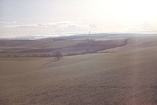
Salisbury Plain is a chalk plateau in the south western part of central southern England covering 300 square miles (780 km2). It is part of a system of chalk downlands throughout eastern and southern England formed by the rocks of the Chalk Group and largely lies within the county of Wiltshire, but stretches into Hampshire.

The South Downs are a range of chalk hills that extends for about 260 square miles (670 km2) across the south-eastern coastal counties of England from the Itchen valley of Hampshire in the west to Beachy Head, in the Eastbourne Downland Estate, East Sussex, in the east. The Downs are bounded on the northern side by a steep escarpment, from whose crest there are extensive views northwards across the Weald. The South Downs National Park forms a much larger area than the chalk range of the South Downs and includes large parts of the Weald.

The Berkshire Downs are a range of chalk downland hills in southern England, part of the North Wessex Downs Area of Outstanding Natural Beauty. The Berkshire Downs are wholly within the traditional county of Berkshire, although split between the current ceremonial counties of Berkshire and Oxfordshire. The western parts of the downs are also known as the Lambourn Downs.

The North Wessex Downs Area of Outstanding Natural Beauty (AONB) is located in the English counties of Berkshire, Hampshire, Oxfordshire and Wiltshire. The name North Wessex Downs is not a traditional one, the area covered being better known by various overlapping local names, including the Berkshire Downs, the North Hampshire Downs, the White Horse Hills, the Lambourn Downs, the Marlborough Downs, the Vale of Pewsey and Savernake Forest.
The Dorset Downs are an area of chalk downland in the centre of the county Dorset in south west England. The downs are the most western part of a larger chalk formation which also includes Cranborne Chase, Salisbury Plain, Hampshire Downs, Chiltern Hills, North Downs and South Downs.

Cranborne Chase is a chalk plateau in central southern England, straddling the counties Dorset, Hampshire and Wiltshire. The plateau is part of the English Chalk Formation and is adjacent to Salisbury Plain and the West Wiltshire Downs in the north, and the Dorset Downs to the south west. The scarp slope of the hills faces the Blackmore Vale to the west, and to some extent the Vale of Wardour to the north. The chalk gently slopes south and dips under clays and gravels. The highest point is Win Green Down, in Wiltshire, at 910 feet (280 m).

Alvediston is a small village and civil parish in Wiltshire, England, about 7 miles (11 km) east of Shaftesbury and 11 miles (18 km) southwest of Salisbury. The area is the source of the River Ebble and is within the Cranborne Chase and West Wiltshire Downs Area of Outstanding Natural Beauty.

Bowerchalke is a village and civil parish in Wiltshire, England, about 9 miles (14 km) southwest of Salisbury. It is in the south of the county, about 1 mile (1.6 km) from the boundary with Dorset and 2 miles (3.2 km) from that with Hampshire. The parish includes the hamlets of Mead End, Misselfore and Woodminton.
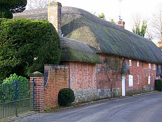
Broad Chalke, sometimes spelled Broadchalke, Broad Chalk or Broadchalk, is a village and civil parish in Wiltshire, England, about 8 miles (13 km) west of the city of Salisbury. The civil parish includes the hamlets of Knapp, Mount Sorrel and Stoke Farthing.

Beacon Hill, Warnford is a 46.4-hectare (115-acre) biological Site of Special Scientific Interest west of Warnford in Hampshire. It is a Nature Conservation Review site, and an area of 40.1 hectares is a national nature reserve. There is a round barrow cemetery dating to the Late Neolithic or Bronze Age on the hill, and this is a scheduled monument.
Baverstock Juniper Bank is a 2.6 hectare Biological Site of Special Scientific Interest to the north of the village of Baverstock in Wiltshire, England. Baverstock Juniper Bank is within the Cranborne Chase and West Wiltshire Downs Area of Outstanding Natural Beauty. The ungrazed chalk grassland is home to over 500 bushes of the lowland juniper, Juniperus communis, subspecies communis. Their seeds attract flocks of finches and yellowhammers to the location as a feeding site in winter. Uncommon species such a horseshoe vetch and pyramidal orchid are to be found at the SSSI. Butterflies such as the brimstone, speckled wood and small heath have been seen visiting the site.
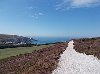
Headon Warren and West High Down is a 276.3 hectare Site of Special Scientific Interest (SSSI) located at the westernmost end of the Isle of Wight. The SSSI encompasses Headon Warren, a heather clad down to the north, the chalk downs of West High Down and Tennyson Down to the south, and the Needles, The Needles Batteries and Alum Bay to the west.

Scratchbury Camp is the site of an Iron Age univallate hillfort on Scratchbury Hill, overlooking the Wylye valley about 1km northeast of the village of Norton Bavant in Wiltshire, England. The fort covers an area of 37 acres (15 ha) and occupies the summit of the hill on the edge of Salisbury Plain, with its four-sided shape largely following the natural contours of the hill.

Dorset is a county located in the middle of the south coast of England. It lies between the latitudes 50.512°N and 51.081°N and the longitudes 1.682°W and 2.958°W, and occupies an area of 2,653 km2. It spans 90 kilometres (56 mi) from east to west and 63 kilometres (39 mi) from north to south.

Harting Downs is a 336.3-hectare (831-acre) biological Site of Special Scientific Interest west of Midhurst in West Sussex. It is a Nature Conservation Review site, Grade I and an area of 206.6 hectares is a Local Nature Reserve which is owned and managed by the National Trust.

Levin Down is a 25.6-hectare (63-acre) biological Site of Special Scientific Interest south of Midhurst in West Sussex. It is managed by the Sussex Wildlife Trust.

West Harting Down SSSI is a 13.9-hectare (34-acre) biological Site of Special Scientific Interest west of South Harting in West Sussex. It is part of the 317.9-hectare (786-acre) West Harting Down, which is managed by Forestry England.

Martin and Tidpit Downs is a 367.5-hectare (908-acre) biological Site of Special Scientific Interest north-west of Fordingbridge in Hampshire. Martin Down is a 341-hectare (840-acre) national nature reserve and an area of 115 hectares is a Nature Conservation Review site, Grade I. Bokerley Dyke, a prehistoric linear earthwork and scheduled monument, runs through the site.
