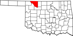
Winchester, Woods County, Oklahoma

Last updated

Winchester is a populated place in Woods County, Oklahoma. [1] [2] It is located at an elevation of 1,483 feet at a point 9.1 miles west-southwest of Hardtner, Kansas, and 12 miles northwest of the Woods County seat of Alva, Oklahoma. [2]

History

Winchester, as part of what became Woods County, was opened to settlement by the Land Run of 1893. [3] A post office was created there in 1895 [4] while the area was still Oklahoma Territory. A 1902 Woods County Directory indicates the town had daily stage service to Alva. [5] Casual mentions of Winchester can be found in Renfrew’s Record, the newspaper in Alva, from at least 1902 to 1921. [6] [7] A 1911 map of Woods County shows its location, together with the ephemeral settlements of Fitzlen to its east, Gamet to its southeast, Flagg to its southwest, and Faulkner, Abbie & Kingman to its west. [8]

But Winchester was not built on a railway: the rail line from Kiowa, Kansas came into Alva from the northeast, running well east of Winchester, [9] [8] [10] while the Buffalo and Northwestern Railroad, which connected Buffalo, Oklahoma with Waynoka by way of Freedom in the 1919–20 timeframe, was too far south. [11] Further, the town was bypassed by major highways, with the nearest, US Route 281, well to the location’s east. [12] The town did not thrive, and the post office closed in 1939. [4]

This settlement is not to be confused with the modern-day community of Winchester, Oklahoma, in Okmulgee County. [13]

Related Research Articles

<span class="mw-page-title-main">Woods County, Oklahoma</span> County in Oklahoma, United States

Woods County is a county located in the northwestern part of the U.S. state of Oklahoma. As of the 2020 census, the population was 8,624. Its county seat is Alva. The county is named after Samuel Newitt Wood, a renowned Kansas populist.

<span class="mw-page-title-main">Harper County, Oklahoma</span> County in Oklahoma, United States

Harper County is a county located in the U.S. state of Oklahoma. As of the 2020 census, the population was 3,272, making it the third-least populous county in Oklahoma. The county seat is Buffalo. It was created in 1907 from the northwestern part of Woodward County, and named for Oscar Green Harper, who was clerk of the Oklahoma Constitutional Convention.

<span class="mw-page-title-main">Craig County, Oklahoma</span> County in Oklahoma, United States

Craig County is a county in the U.S. state of Oklahoma. As of the 2020 census, the population was 14,107. Its county seat is Vinita. The county was organized in 1907, shortly before statehood, and named for Granville Craig, a prominent Cherokee farmer who lived in the Bluejacket area.

<span class="mw-page-title-main">Boise City, Oklahoma</span> City in Oklahoma, United States

Boise City is a city in and the county seat of Cimarron County, in the Panhandle of Oklahoma, United States. The population was 1,166 at the 2020 census, a decline of 7.9 percent from 1,266 in 2010.

<span class="mw-page-title-main">Buffalo, Oklahoma</span> Town in Oklahoma, United States

Buffalo is a town and county seat of Harper County, Oklahoma, United States. As of the 2020 census, the town’s population was 1,039. It was named after the Buffalo Creek valley, in which it is located.

<span class="mw-page-title-main">Idabel, Oklahoma</span> City in Oklahoma, United States

Idabel is a city in and the county seat of McCurtain County, Oklahoma, United States. The population was 7,010 at the 2010 census. It is in Oklahoma's southeast corner, a tourist area known as Choctaw Country.

<span class="mw-page-title-main">Winchester, Oklahoma</span> Town in Oklahoma, United States

Winchester is a town in Okmulgee County, Oklahoma, United States. The population was 546 at the 2020 census, an increase of 5.8% from the figure of 516 recorded in 2010. It is a recently built residential community, having incorporated February 18, 1974.

<span class="mw-page-title-main">Freedom, Oklahoma</span> City in Oklahoma, United States

Freedom is a town in Woods County, Oklahoma, United States. It lies twenty-five miles west of Alva, on the banks of the Cimarron River. The population was 174 at the time of the 2020 Census.

<span class="mw-page-title-main">Oklahoma State Highway 14</span> State highway in Oklahoma, United States

State Highway 14, abbreviated as SH-14, is a highway maintained by the U.S. state of Oklahoma. It is 27.85 miles (44.82 km) long, with its entire route falling in Woods County in the northwestern part of the state. It does not have any lettered spur routes.

The Alva Review-Courier is a weekly newspaper for Alva, Oklahoma, and surrounding areas. The newspaper was purchased in 1990 by Martin Broadcasting Corporation. The President was Lynn L. Martin and the vice-president was Marione E. Martin. In 2023, the Publisher and Editor was Marione Martin.

<span class="mw-page-title-main">Wheatland, Oklahoma</span> Neighborhood in Oklahoma, Oklahoma, United States

Wheatland is a neighborhood located on State Highway 152 in southwestern Oklahoma City, Oklahoma, United States. ZIP Codes that cover the area include 73097 and 73169.

The Choctaw, Oklahoma and Gulf Railroad (CO&G), known informally as the "Choctaw Route," was an American railroad in the states of Arkansas and Oklahoma.

<span class="mw-page-title-main">Alva, Oklahoma</span> City in Oklahoma, United States

Alva is a city in and the county seat of Woods County, Oklahoma, United States, along the Salt Fork Arkansas River. The population was 5,028 at the time of the 2020 Census, up from 4,945 at the 2010 census. Northwestern Oklahoma State University is located in Alva.

<span class="mw-page-title-main">1954 United States Senate election in Oklahoma</span>

The 1954 United States Senate election in Oklahoma took place on November 2, 1954. Incumbent Democratic Senator Robert S. Kerr ran for re-election to a second term. He faced strong competition in the Democratic primary from former Governor Roy J. Turner, and though he won a sizable victory over Turner in the primary, he fell shy of an outright majority. Turner, however, withdrew from the race before a runoff election could be held. On the Republican side, U.S. Attorney Fred Mock won the nomination following a runoff against newspaper publisher Raymond Fields. In the general election, Kerr ended up easily defeating Mock, but with a significantly reduced victory from 1948.

Natura is a populated place in Okmulgee County, Oklahoma. It is located about 10 miles north of the City of Okmulgee off State Highway 16, east of both the town of Beggs and US-75.

Dighton is a populated place in Okmulgee County, Oklahoma. It is about 7 miles east-northeast of Henryetta, Oklahoma, and is located south of US Route 266 on Bartlett Road.

Little is a populated place in Seminole County, Oklahoma, at an elevation of 968 feet. It is north of the City of Seminole and east of Shawnee, Oklahoma, located at the intersection of US Route 377 and Oklahoma State Highway 99A, just south of Interstate 40. It had a post office from August 14, 1902 to November 30, 1916. It was named for Thomas Little, a prominent Seminole and second chief of the tribe.

Doby was a town that existed in the Oklahoma Panhandle in Cimarron County, around the time of Oklahoma statehood in 1907. It was located four or five miles northwest of Boise City. Its post office was established February 5, 1908.

Dilworth was one of the many oil boomtowns created in Kay County, Oklahoma during the early part of the 20th Century. It was located about 10.5 miles northwest of Newkirk, the county seat, or about 14 miles by present-day roads. While it is now designated a Populated Place, it is considered a ghost town.

References

  1. "Winchester". Geographic Names Information System . United States Geological Survey, United States Department of the Interior . Retrieved November 26, 2021.
  2. 1 2 "Winchester (in Woods County, OK) Populated Place Profile". HomeTownLocator. Retrieved November 13, 2021.
  3. "Oklahoma Territory". Barry Lawrence Ruderman Antique Maps. Retrieved November 13, 2021.
  4. 1 2 Carson, Mary L. (1987). A Guide to Treasure in Oklahoma, Volume 3. Carson Enterprises Inc. p. 438. ISBN   0-941620-38-7.
  5. "Woods County, Oklahoma 1902 Directory". Genealogy Trails. Retrieved November 14, 2021.
  6. "Some Alva Visitors". Renfrew’s Record (Alva, Okla. Terr.), Vol. 1, No. 42, Ed. 1, p.6, Thursday, August 28, 1902 (accessed on The Gateway to Oklahoma History). Retrieved November 13, 2021.
  7. "Article". Renfrew's Record (Alva, Okla.), Vol. 20, No. 17, Ed. 1, P.9, Friday, February 18, 1921 (accessed on The Gateway to Oklahoma History). Retrieved November 13, 2021.
  8. 1 2 "Woods County, Oklahoma 1911 Map". My Genealogy Hound. Retrieved November 14, 2021.
  9. "Alva, OK". Mapquest. Retrieved November 14, 2021.
  10. "Oklahoma 2018-2020 State Railroad Map" (PDF). Oklahoma Department of Transportation. Retrieved October 21, 2021.
  11. "Winchester, Oklahoma 73717". Google Maps. Retrieved November 14, 2021.
  12. "Winchester, OK 73717". Google Maps. Retrieved April 22, 2020.
  13. "Winchester". Glynis Coleman, Oklahoma Historical Society. Retrieved November 14, 2021.

36°57′26″N98°47′50″W / 36.95722°N 98.79722°W / 36.95722; -98.79722