Dacoma, Oklahoma

Last updated

Dacoma, Oklahoma
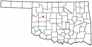
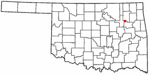
OKMap-doton-Dacoma.PNG
Location of Dacoma, Oklahoma
Coordinates: 36°39′35″N98°33′49″W / 36.65972°N 98.56361°W / 36.65972; -98.56361
Country United States
State Oklahoma
County Woods
Area
[1]
  Total0.52 sq mi (1.36 km2)
  Land0.52 sq mi (1.36 km2)
  Water0.00 sq mi (0.00 km2)
Elevation
[2]
1,365 ft (416 m)
Population
 (2020)
  Total109
  Density208.41/sq mi (80.43/km2)
Time zone UTC-6 (Central (CST))
  Summer (DST) UTC-5 (CDT)
ZIP code
73731
Area code 580
FIPS code 40-19050 [3]
GNIS feature ID2412401 [2]

Dacoma is a town in Woods County, Oklahoma, United States. The population was 107 at the 2010 census, down from 148 in 2000.

Contents

Geography

Dacoma is located 16 miles (26 km) southeast of Alva, the county seat. [4]

According to the United States Census Bureau, the town has a total area of 0.5 square miles (1.3 km2), all land.

Demographics

Historical population
CensusPop.Note
1910 146
1920 26581.5%
1930 33225.3%
1940 274−17.5%
1950 256−6.6%
1960 219−14.5%
1970 2263.2%
1980 2260.0%
1990 182−19.5%
2000 148−18.7%
2010 107−27.7%
2020 1091.9%
U.S. Decennial Census

As of the census [3] of 2000, there were 148 people, 64 households, and 41 families residing in the town. The population density was 284.6 inhabitants per square mile (109.9/km2). There were 88 housing units at an average density of 169.2 per square mile (65.3/km2). The racial makeup of the town was 97.30% White, 1.35% Native American, and 1.35% from two or more races. Hispanic or Latino of any race were 2.70% of the population.

There were 64 households, out of which 23.4% had children under the age of 18 living with them, 57.8% were married couples living together, 3.1% had a female householder with no husband present, and 34.4% were non-families. 34.4% of all households were made up of individuals, and 20.3% had someone living alone who was 65 years of age or older. The average household size was 2.31 and the average family size was 3.00.

In the town, the population was spread out, with 20.9% under the age of 18, 8.1% from 18 to 24, 20.3% from 25 to 44, 28.4% from 45 to 64, and 22.3% who were 65 years of age or older. The median age was 45 years. For every 100 females, there were 100.0 males. For every 100 females age 18 and over, there were 91.8 males.

The median income for a household in the town was $24,375, and the median income for a family was $31,250. Males had a median income of $22,500 versus $20,625 for females. The per capita income for the town was $21,848. There were 12.5% of families and 10.3% of the population living below the poverty line, including no under eighteens and none of those over 64.

Education

Dacoma shares a school district with the nearby town of Carmen.

Related Research Articles

<span class="mw-page-title-main">Milton, Illinois</span> Village in Illinois, United States

Milton is a village in Pike County, Illinois, United States. The population was 271 at the 2010 census, a decline from 274 in 2000.

<span class="mw-page-title-main">East Pepperell, Massachusetts</span> Census-designated place in Massachusetts, United States

East Pepperell is a village and census-designated place (CDP) in the town of Pepperell in Middlesex County, Massachusetts, United States. The population was 2,120 at the 2020 census.

<span class="mw-page-title-main">Carmen, Oklahoma</span> Town in Oklahoma, United States

Carmen is a town in Alfalfa County, Oklahoma, United States. The population was 355 at the 2010 census.

<span class="mw-page-title-main">Kenefic, Oklahoma</span> Town in Oklahoma, United States

Kenefic is a town in Bryan County, Oklahoma, United States. The population was 196 at the 2010 census, a 2 percent increase from the total of 192 recorded in 2000. The town was named for William Kenefick, president of the Missouri, Oklahoma and Gulf Railroad (MO&G), which had constructed a rail line through the region. The town name has been spelled both Kenefic and Kenefick throughout its history.

<span class="mw-page-title-main">Faxon, Oklahoma</span> Town in Oklahoma, United States

Faxon is a town in Comanche County, Oklahoma, United States. It is located on Oklahoma State Highway 36 about 18.3 driving miles southwest of Lawton. The population was 136 at the 2010 census. It is included in the Lawton, Oklahoma Metropolitan Statistical Area.

<span class="mw-page-title-main">Indiahoma, Oklahoma</span> Town in Oklahoma, United States

Indiahoma is a town in Comanche County, Oklahoma, United States. It is located just south of US Route 62, about 24.4 driving miles west of Lawton.

<span class="mw-page-title-main">Lawrence Creek, Oklahoma</span> Town in Oklahoma, United States

Lawrence Creek is a town in Creek County, Oklahoma, United States. Incorporated March 15, 1983, it is primarily a bedroom community whose employed residents work in Sapulpa and Tulsa. The population was 149 at the 2010 census, a gain of 25.2 percent over the figure of 119 recorded in 2000.

<span class="mw-page-title-main">Taloga, Oklahoma</span> Town in Oklahoma, United States

Taloga is a town in Dewey County, Oklahoma, United States. The population was 288 at the time of the 2020 census.

<span class="mw-page-title-main">Carrier, Oklahoma</span> Town in Oklahoma, United States

Carrier is a town in Garfield County, Oklahoma, United States. The population was 85 at the 2010 census.

<span class="mw-page-title-main">Covington, Oklahoma</span> Town in Oklahoma, United States

Covington is a town in Garfield County, Oklahoma, United States. The population was 477 at the 2020 census.

<span class="mw-page-title-main">Drummond, Oklahoma</span> Town in Oklahoma, United States

Drummond is a town in Garfield County, Oklahoma, United States. The population was 455 at the 2010 census, up from 405 in 2000.

<span class="mw-page-title-main">Kremlin, Oklahoma</span> Town in Oklahoma, United States

Kremlin is a town in Garfield County, Oklahoma, United States. The population was 255 at the 2010 census, a 6.25 percent increase from the figure of 240 in 2000.

<span class="mw-page-title-main">Lahoma, Oklahoma</span> Town in Oklahoma, United States

Lahoma is a town in Garfield County, Oklahoma, United States. The population was 611 at the 2010 census, a 5.9 percent gain over the figure of 577 in 2000. Its name was formed from the last three syllables of Oklahoma. Until the 1960s, Lahoma was a farm town. Later, it became primarily a bedroom community for people who commuted to work in Enid.

<span class="mw-page-title-main">Nash, Oklahoma</span> Town in Oklahoma, United States

Nash is a town in Grant County, Oklahoma, United States. The population was 204 at the 2010 census, an 8.9 percent decline from the figure of 224 in 2000.
<span class="mw-page-title-main">East Duke, Oklahoma</span> Town in Oklahoma, United States

East Duke is a town in Jackson County, Oklahoma, United States. The population was 424 at the 2010 census.

<span class="mw-page-title-main">LeFlore, Oklahoma</span> Town in Oklahoma, United States

LeFlore is a town in LeFlore County, Oklahoma, United States. It is part of the Fort Smith, Arkansas-Oklahoma Metropolitan Statistical Area. The population was 198 at the 2010 census, an increase of 13.1 percent over the figure of 168 in 2000. Although the legal town name is spelled in the two-word form, the official federal name for the place and the postal name used is Leflore.

<span class="mw-page-title-main">Haworth, Oklahoma</span> Town in Oklahoma, United States

Haworth is a town in McCurtain County, Oklahoma, United States. The population was 297 at the 2010 census.

<span class="mw-page-title-main">Richfield, Adams County, Wisconsin</span> Town in Wisconsin, United States

Richfield is a town in Adams County in the U.S. state of Wisconsin. The population was 158 at the 2010 census. The ghost town of Pilot Knob was located in the town.

<span class="mw-page-title-main">Canton, Wisconsin</span> Town in Wisconsin, United States

Canton is a town in Buffalo County in the U.S. state of Wisconsin. The population was 305 at the 2010 census. The ghost town of Springdale was located in the town.

<span class="mw-page-title-main">Chattanooga, Oklahoma</span> Town in Oklahoma, United States

Chattanooga is a town in Comanche and Tillman counties in the U.S. state of Oklahoma. It is located on Oklahoma State Highway 36 about 23.7 driving miles southwest of Lawton. The population was 461 at the 2010 census. The Comanche County portion of Chattanooga is included in the Lawton, Oklahoma Metropolitan Statistical Area.

References

  1. "ArcGIS REST Services Directory". United States Census Bureau. Retrieved September 20, 2022.
  2. 1 2 U.S. Geological Survey Geographic Names Information System: Dacoma, Oklahoma
  3. 1 2 "U.S. Census website". United States Census Bureau . Retrieved January 31, 2008.
  4. Leslie, Loleta. Encyclopedia of Oklahoma History and Culture. "Dacoma." Retrieved November 27, 2013.