Windeck | |
|---|---|
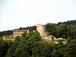 Windeck Castle | |
 Coat of arms | |
Location of Windeck within Rhein-Sieg-Kreis district 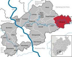 | |
 | |
| Location of Windeck | |
 Windeck  Windeck | |
| Coordinates: 50°48′00″N7°34′00″E / 50.80000°N 7.56667°E | |
| Country | Germany |
| State | North Rhine-Westphalia |
| Admin. region | Köln |
| District | Rhein-Sieg-Kreis |
| Subdivisions | 66 |
| Government | |
| • Mayor (2018–23) | Alexandra Christine Gauß [1] (Greens) |
| Area | |
• Total | 107.26 km2 (41.41 sq mi) |
| Elevation | 143 m (469 ft) |
| Population (2023-12-31) [2] | |
• Total | 19,254 |
| • Density | 179.51/km2 (464.92/sq mi) |
| Time zone | UTC+01:00 (CET) |
| • Summer (DST) | UTC+02:00 (CEST) |
| Postal codes | 51570 |
| Dialling codes | 02292 (Rosbach, Dattenfeld, Schladern, Leuscheid, Hurst), 02243 (Herchen), 02682 (Au), 02686 (Kocherscheid), 02295 (Gutmannseichen) |
| Vehicle registration | SU |
| Website | https://gemeinde-windeck.de/ |
Windeck is a municipality in the Rhein-Sieg district, in North Rhine-Westphalia, Germany. It is situated on the river Sieg, approx. 35km east of Bonn and 35km west of Siegen. The name Windeck comes from the Windeck castle ruins and the nearby village of Windeck.
Contents
The community of Windeck was formed in 1969 through the merger of the communities of Dattenfeld, Herchen and Rosbach. Today Windeck consists of 58 villages and some hamlets and homesteads. The most populated are:
| Village | Population |
|---|---|
| Rosbach | 4009 |
| Dattenfeld | 2287 |
| Leuscheid | 1171 |
| Schladern | 1128 |
| Herchen | 974 |
| Hurst | 815 |
| Wilberhofen | 532 |
| Halscheid | 309 |
Other villages are Oppertzau, Dreisel, Werfen, Stromberg and Au an der Sieg.
In Windeck, the Leina company produces first aid kits and warning triangles.
