Lohmar

Last updated

Lohmar
Honrath2007.jpg
Protestant church in Honrath
DEU Lohmar COA.svg
Location of Lohmar within Rhein-Sieg-Kreis district
Lohmar in SU.svgMuch
Germany adm location map.svg
Red pog.svg
Lohmar
North Rhine-Westphalia location map 01.svg
Red pog.svg
Lohmar
Coordinates: 50°49′N7°13′E / 50.817°N 7.217°E / 50.817; 7.217
Country Germany
State North Rhine-Westphalia
Admin. region Köln
District Rhein-Sieg-Kreis
Subdivisions12
Government
   Mayor (202025) Claudia Wieja [1] (Greens)
Area
  Total
65.5 km2 (25.3 sq mi)
Elevation
64 m (210 ft)
Population
 (2023-12-31) [2]
  Total
30,894
  Density470/km2 (1,200/sq mi)
Time zone UTC+01:00 (CET)
  Summer (DST) UTC+02:00 (CEST)
Postal codes
53797
Dialling codes 02205, 02206, 02241, 02246, 02247
Vehicle registration SU
Website www.lohmar.de

Lohmar (Ripuarian: Luhme) is a municipality and a town in the Rhein-Sieg district, in North Rhine-Westphalia, Germany.

Contents

Geography

Lohmar is located about 20 km east of Cologne and 15 km north-east of Bonn in the Bergisches Land area. Because it is only 20 minutes by car to Cologne or Bonn, Lohmar is a popular place for commuters.

The municipality of Lohmar is divided into two parts: Lohmar itself and Wahlscheid 7 km to the north. About a third of the total population lives in Wahlscheid (a separate municipality until 1969). In total Lohmar comprises 30 districts. The most important are Lohmar itself (est. population approx. 9500), Donrath (2200), Heide (2100) and Birk (1400) in the south, as well as Wahlscheid (3200), Neuhonrath (2000), Honrath (1500) and Agger (1000) in the north.

Lohmar, Donrath, Wahlscheid, Neuhonrath and Agger are located in the Agger valley, the other villages in the uplands.

History

Lohmar was first mentioned as a donation of archbishop Sigewid to the church of Cologne. A farmyard in Lomereis mentioned.

Lohmar is also mentioned on the Arc de Triomphe in Paris as a place of Napoleon's visit. While his inspection of the army positioned in the Rhineland in 1811 he lived in Schloss Auel in Lohmar.

Politics

Town council

The town council consists of 40 members. The current breakdown after the local elections held on 13 September 2020 is as follows:

The CDU and Grünen govern the town as a coalition.

Mayor

Coat of arms

Meeting of Agger (upper) and Sulz (lower) Suelzmuendung.jpg
Meeting of Agger (upper) and Sülz (lower)

The coat of arms contains a lion of Berg in the upper fragment. It symbolizes the former jurisdiction by the Earldom of Berg. The lower fraction shows the meeting of the Agger and the Sülz rivers.

Twin towns – sister cities

Lohmar is twinned with: [3]

Transport

Lohmar is served by Honrath railway station on the Cologne–Overath railway. A train to Cologne stops every 30 minutes. The trip to Cologne lasts about 30 minutes. A service runs in the other direction to Overath every 30 minutes.

Roads

Lohmar is connected to the Bundesautobahn 3 with following exits:

The Bundesautobahn 4 connects through exit

Airports

The Cologne Bonn Airport is reachable within 25 minutes.

Related Research Articles

<span class="mw-page-title-main">North Rhine-Westphalia</span> State in Germany

North Rhine-Westphalia or North-Rhine/Westphalia, commonly shortened to NRW, is a state (Bundesland) in Western Germany. With more than 18 million inhabitants, it is the most populous state in Germany. Apart from the city-states, it is also the most densely populated state in Germany. Covering an area of 34,084 km2 (13,160 sq mi), it is the fourth-largest German state by size.

<span class="mw-page-title-main">Bergisch Gladbach</span> City in North Rhine-Westphalia, Germany

Bergisch Gladbach is a city in the Cologne/Bonn Region of North Rhine-Westphalia, Germany, and capital of the Rheinisch-Bergischer Kreis (district).

<span class="mw-page-title-main">Siegburg</span> Town in North Rhine-Westphalia, Germany

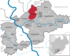
Siegburg is a city in the district of Rhein-Sieg-Kreis in North Rhine-Westphalia, Germany. It is located on the banks of the rivers Sieg and Agger, 10 kilometres (6.2 mi) from the former seat of West German government Bonn and 26 kilometres (16 mi) from Cologne. The population of the city was 39,192 in the 2013 census.

<span class="mw-page-title-main">Langenfeld, Rhineland</span> Town in North Rhine-Westphalia, Germany

Langenfeld is a town in North Rhine-Westphalia (Germany) in the district of Mettmann. The suburban city is located between Düsseldorf and Cologne. Langenfeld was formed from the two localities of Richrath and Reusrath and received city rights in 1948.

<span class="mw-page-title-main">Marienheide</span> Municipality in North Rhine-Westphalia, Germany

Marienheide is a municipality in the Oberbergischer Kreis, in North Rhine-Westphalia, Germany.

<span class="mw-page-title-main">Overath</span> Town in North Rhine-Westphalia, Germany

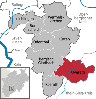
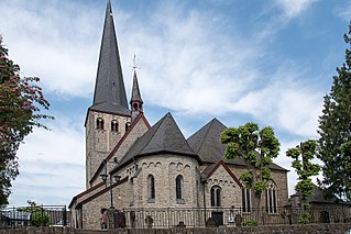
Overath is a town in the Rheinisch-Bergischer district of North Rhine-Westphalia, Germany.

<span class="mw-page-title-main">Kaarst</span> Town in North Rhine-Westphalia, Germany

Kaarst is a town in Germany. It lies in the district of Rhein-Kreis Neuss in North Rhine-Westphalia. It is 5 km west of Neuss and 12 km east of Mönchengladbach.

<span class="mw-page-title-main">Rösrath</span> Town in North Rhine-Westphalia, Germany

Rösrath is a town in the Rheinisch-Bergischer Kreis (district) in North Rhine-Westphalia, Germany. The earliest known documents mentioning the settlement Rösrath can be found in documents dated to 1356. There have been findings of Paleolithic and Mesolithic tools in the town area Forsbach. The community was elevated to the town status in 2001.

<span class="mw-page-title-main">Neunkirchen-Seelscheid</span> Municipality in North Rhine-Westphalia, Germany

Neunkirchen-Seelscheid is a municipality in the Rhein-Sieg district in the southern part of North Rhine-Westphalia, Germany. Beside the two principal places Neunkirchen and Seelscheid there are numerous smaller localities among the municipality.

<span class="mw-page-title-main">Meckenheim</span> Town in North Rhine-Westphalia, Germany

Meckenheim is a town in the Rhein-Sieg district, in North Rhine-Westphalia, Germany.

<span class="mw-page-title-main">Drolshagen</span> Town in North Rhine-Westphalia, Germany

Drolshagen is a town belonging to the district of Olpe in the Regierungsbezirk of Arnsberg in North Rhine-Westphalia, Germany, lying roughly 5 km west of Olpe.

<span class="mw-page-title-main">Kürten</span> Village in Germany

Kürten is a village and a municipality in the Rheinisch-Bergischer Kreis, in North Rhine-Westphalia, Germany.

<span class="mw-page-title-main">Jüchen</span> Municipality in North Rhine-Westphalia, Germany

Jüchen is a municipality in the Rhein-Kreis Neuss, in North Rhine-Westphalia, Germany. It is situated approximately 17 km southwest of Neuss and 10 km southeast of Mönchengladbach.

<span class="mw-page-title-main">Rheinbach</span> Town in North Rhine-Westphalia, Germany

Rheinbach is a town in the Rhein-Sieg-Kreis district (Landkreis), in North Rhine-Westphalia, Germany. It belongs to the administrative district (Regierungsbezirk) of Cologne.

<span class="mw-page-title-main">Sankt Augustin</span> Town in North Rhine-Westphalia, Germany

Sankt Augustin is a town in the Rhein-Sieg district in North Rhine-Westphalia, Germany. It is named after the patron saint of the Steyler missionaries, Saint Augustine of Hippo (354-430). The missionaries established the "Saint Augustine Monastery" near the current town centre in 1913. The municipality of Sankt Augustin was established in 1969, and on September 6, 1977, Sankt Augustin acquired town privileges. Sankt Augustin is situated about 8 km northeast of Bonn and 8 km southwest of Siegburg. Sankt Augustin belongs to the economic region of Bonn/Rhein-Sieg as well as the scientific region of Bonn. With over 59,000 inhabitants, it is the second-largest town in the Rhein-Sieg district.

<span class="mw-page-title-main">Hamminkeln</span> Town in North Rhine-Westphalia, Germany

Hamminkeln is a town in the district of Wesel, in North Rhine-Westphalia, Germany. It is situated on the river Issel, approximately 10 kilometers north of Wesel and 15 km south of Bocholt. It is twinned with Sedgefield, United Kingdom and the largest town in the district of Wesel.

<span class="mw-page-title-main">Siegburg–Olpe railway</span>

The Siegburg–Olpe railway or Agger Valley Railway is a single-tracked, non-electrified branch line in the German state of North Rhine-Westphalia. Part of a direct link from Cologne, only the section from Overath to Gummersbach-Dieringhausen is still in operation. The section of line from Siegburg to Overath and from Dieringhausen to Olpe are closed.

<span class="mw-page-title-main">Schlingenbach</span> River in Germany

Schlingenbach is a small river of North Rhine-Westphalia, Germany. It is 6.6 km (4.1 mi) long and flows as a left tributary into the Agger near Overath.

The Cologne–Overath railway is a single-track, non-electrified railway in the German state of North Rhine-Westphalia. It was opened in 1910 to connect the historic Siegburg–Olpe railway directly to Cologne and required the construction of the Hoffnungsthal tunnel. The section from Hoffnungsthal to Rösrath partly used the track of the Cologne–Lindlar railway, which is now largely disused west of Bergisch Gladbach. The line, like the Siegburg–Olpe line, is also called the Aggertalbahn, although it leaves the valley of the Agger not far from Overath.

The Oberbergische Bahn is a Regionalbahn rail service running between Cologne Hansaring and Lüdenscheid in the German state of North Rhine-Westphalia (NRW).

References

  1. Wahlergebnisse in NRW Kommunalwahlen 2020, Land Nordrhein-Westfalen, accessed 29 June 2021.
  2. "Bevölkerung der Gemeinden Nordrhein-Westfalens am 31. Dezember 2023 – Fortschreibung des Bevölkerungsstandes auf Basis des Zensus vom 9. Mai 2011" (in German). Landesbetrieb Information und Technik NRW . Retrieved 20 June 2024.
  3. "Städtepartnerschaften". lohmar.de (in German). Lohmar. Retrieved 21 January 2021.