Winfield, Tennessee

Last updated

Winfield, Tennessee
Winfield-houses-tn1.jpg
Scott County Tennessee Incorporated and Unincorporated areas Winfield Highlighted 4781280.svg
Location of Winfield in Scott County, Tennessee.
Coordinates: 36°33′43″N84°27′2″W / 36.56194°N 84.45056°W / 36.56194; -84.45056
Country United States
State Tennessee
County Scott
Incorporated1983 [1]
Area
[2]
  Total6.80 sq mi (17.63 km2)
  Land6.79 sq mi (17.60 km2)
  Water0.01 sq mi (0.03 km2)
Elevation
[3]
1,326 ft (404 m)
Population
 (2020) [4]
  Total947
  Density139.39/sq mi (53.81/km2)
Time zone UTC-5 (Eastern (EST))
  Summer (DST) UTC-4 (EDT)
ZIP code
37892
Area code 423
FIPS code 47-81280 [5]
GNIS feature ID1304634 [3]

Winfield is a town in Scott County, Tennessee, United States. Originally named Chitwood in the late 18th century for Revolutionary War hero Captain James Chitwood after his family settled the area extensively, the name was changed following the Civil War due to the family's mixed allegiances. The name Winfield was picked in honor of US army general Winfield Scott. The population was 947 at the 2020 census and 967 at the 2010 census.

Contents

Geography

Winfield is located at 36°33′43″N84°27′2″W / 36.56194°N 84.45056°W / 36.56194; -84.45056 (36.561889, -84.450425). [6]

According to the United States Census Bureau, the town has a total area of 6.4 square miles (17 km2), of which 6.4 square miles (17 km2) is land and 0.04 square miles (0.10 km2) (0.31%) is water.

The highest point in Winfield is Chitwood Mountain at 2,139 feet. [7]

Demographics

Historical population
CensusPop.Note
1990 564
2000 91161.5%
2010 9676.1%
2020 947−2.1%
Sources: [8] [9] [4]

2020 census

Winfield racial composition [10]
RaceNumberPercentage
White (non-Hispanic)91296.3%
Native American 10.11%
Asian 60.63%
Other/Mixed 242.53%
Hispanic or Latino 40.42%

As of the 2020 United States census, there were 947 people, 416 households, and 293 families residing in the town.

2000 census

As of the census [5] of 2000, there were 911 people, 356 households, and 259 families residing in the town. The population density was 143.2 inhabitants per square mile (55.3/km2). There were 380 housing units at an average density of 59.7 per square mile (23.1/km2). The racial makeup of the town was 98.13% White, 0.99% Native American, 0.11% Asian, and 0.77% from two or more races. Hispanic or Latino of any race were 0.33% of the population.

There were 356 households, out of which 34.6% had children under the age of 18 living with them, 55.1% were married couples living together, 13.8% had a female householder with no husband present, and 27.2% were non-families. 22.8% of all households were made up of individuals, and 7.6% had someone living alone who was 65 years of age or older. The average household size was 2.56 and the average family size was 2.97.

In the town, the population was spread out, with 27.3% under the age of 18, 10.4% from 18 to 24, 29.4% from 25 to 44, 24.3% from 45 to 64, and 8.6% who were 65 years of age or older. The median age was 32 years. For every 100 females, there were 93.8 males. For every 100 females age 18 and over, there were 94.7 males.

The median income for a household in the town was $25,278, and the median income for a family was $28,077. Males had a median income of $25,260 versus $20,417 for females. The per capita income for the town was $14,059. About 17.7% of families and 19.8% of the population were below the poverty line, including 20.6% of those under age 18 and 27.0% of those age 65 or over.

Media

Related Research Articles

<span class="mw-page-title-main">Inverness Township, Michigan</span> Civil township in Michigan, United States

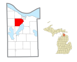
Inverness Township is a civil township of Cheboygan County in the U.S. state of Michigan. The population was 2,261 at the 2010 census. It was named after Inverness in Scotland.

<span class="mw-page-title-main">Greene Township, Beaver County, Pennsylvania</span> Township in Pennsylvania, United States

Greene Township is a township in Beaver County, Pennsylvania, United States. The population was 2,194 at the 2020 census. It is part of the Pittsburgh metropolitan area.

<span class="mw-page-title-main">East Vandergrift, Pennsylvania</span> Borough in Pennsylvania, United States

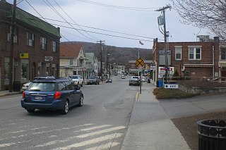
East Vandergrift is a borough in Westmoreland County in the U.S. state of Pennsylvania. The population was 601 at the 2020 census.

<span class="mw-page-title-main">Caryville, Tennessee</span> Town in Tennessee, United States

Caryville is a town in Campbell County, Tennessee, United States. The population was 2,297 at the 2010 census.

<span class="mw-page-title-main">Jacksboro, Tennessee</span> Town in Tennessee, United States

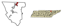
Jacksboro is a town in Campbell County, Tennessee, United States. The population was 2,306 at the 2020 census. It is the county seat of Campbell County.

<span class="mw-page-title-main">Huntingdon, Tennessee</span> Town in Tennessee, United States

Huntingdon is a town in Carroll County, Tennessee, United States. The population was 4,439 at the 2020 census and 3,985 in 2010. It is the county seat of Carroll County.

<span class="mw-page-title-main">Vanleer, Tennessee</span> Town in Tennessee, United States

Vanleer is a town in Dickson County, Tennessee, United States. The population was estimated to be 422 in 2019, up from 395 at the 2010 census. The town is approximately 49 miles northwest of Nashville and is located within the city's greater metropolitan area.

<span class="mw-page-title-main">White Bluff, Tennessee</span> Town in Tennessee, United States

White Bluff is a town in Dickson County, Tennessee, United States. The population was 3,862 at the 2020 census and 3,206 at the 2010 census. The community name derives from the White Bluff Iron Forge.

<span class="mw-page-title-main">Gibson, Tennessee</span> Town in Tennessee, United States

Gibson is a town in Gibson County, Tennessee, United States. The population was 396 at the 2010 census.

<span class="mw-page-title-main">Palmer, Tennessee</span> Town in Tennessee, United States

Palmer is a town in Grundy County, Tennessee, United States. The population was 672 at the 2010 census.

<span class="mw-page-title-main">Orlinda, Tennessee</span> City in Tennessee, United States

Orlinda is a city in Robertson County, Tennessee. The population was 947 at the 2020 census, the community became a city in February 2001. The City of Orlinda conducted its own, independent census 2007. The results of that census were submitted to the State of Tennessee, which conducted a review and random sample before officially certifying the results, which it did in May 2007.

<span class="mw-page-title-main">Huntsville, Tennessee</span> Town in Tennessee, United States

Huntsville is a town in Scott County, Tennessee, United States. The population was 1,270 at the 2020 census and 1,248 at the 2010 census. It is the county seat of Scott County.

<span class="mw-page-title-main">Oneida, Tennessee</span> Town in Tennessee, United States

Oneida is a town in Scott County, Tennessee, United States. The population was 3,787 at the 2020 census.

<span class="mw-page-title-main">Gordonsville, Tennessee</span> Town in Tennessee, United States

Gordonsville is a town in Smith County, Tennessee, United States. The population was 1,213 at the 2010 census.

Bluff City is a city in Sullivan County, Tennessee. The population was 1,733 at the 2010 census. It is part of the Kingsport-Bristol-Bristol, TN-VA Metropolitan Statistical Area, which is a component of the Johnson City-Kingsport-Bristol, TN-VA Combined Statistical Area, commonly known as the "Tri-Cities" region.

<span class="mw-page-title-main">Dresden, Tennessee</span> Town in Tennessee, United States

Dresden is a town in and the county seat of Weakley County, Tennessee, United States. The population was 3,005 at the 2010 census.

<span class="mw-page-title-main">Whiting, Wisconsin</span> Village in Wisconsin, United States

Whiting is a village in Portage County, Wisconsin, United States and is a suburb of Stevens Point. It is included in the Stevens Point Micropolitan Statistical Area. The population was 1,601 at the 2020 census.

<span class="mw-page-title-main">Winfield, Wisconsin</span> Town in Wisconsin, United States

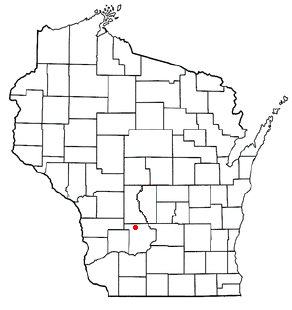
The Town of Winfield is located in Sauk County, Wisconsin, United States. The population was 752 at the 2000 census.

<span class="mw-page-title-main">Kenton, Tennessee</span> Town in Tennessee, United States

Kenton is a town in Gibson and Obion counties, Tennessee. The population was 1,281 at the 2010 census, a decline of 25 from 2000. The Gibson County portion of Kenton is part of the Humboldt, TN Micropolitan Statistical Area, while the Obion County portion is part of the Union City, TN–KY Micropolitan Statistical Area.

<span class="mw-page-title-main">Pawling (village), New York</span> Village in New York, United States

Pawling is a village in Dutchess County, New York, United States. The population was 1,995 at the 2020 census. It is part of the Poughkeepsie–Newburgh–Middletown, NY Metropolitan Statistical Area as well as the larger New York–Newark–Bridgeport, NY-NJ-CT-PA Combined Statistical Area. The John Kane House, a registered historic place, is situated in the village. The village was portrayed as the fictional town of Denning, New York, in the TV series Elementary.

References

  1. Tennessee Blue Book , 2005-2006, pp. 618-625.
  2. "ArcGIS REST Services Directory". United States Census Bureau. Retrieved October 15, 2022.
  3. 1 2 U.S. Geological Survey Geographic Names Information System: Winfield, Tennessee
  4. 1 2 "Census Population API". United States Census Bureau. Retrieved October 15, 2022.
  5. 1 2 "U.S. Census website". United States Census Bureau . Retrieved January 31, 2008.
  6. "US Gazetteer files: 2010, 2000, and 1990". United States Census Bureau. February 12, 2011. Retrieved April 23, 2011.
  7. "Chitwood Mountain Topography, Elevation, Lat, Long, Maps & More | Trails.com". www.trails.com. Archived from the original on May 25, 2015.
  8. "Census of Population and Housing: Decennial Censuses". United States Census Bureau . Retrieved March 4, 2012.
  9. "Incorporated Places and Minor Civil Divisions Datasets: Subcounty Resident Population Estimates: April 1, 2010 to July 1, 2012". Population Estimates. U.S. Census Bureau. Retrieved December 11, 2013.
  10. "Explore Census Data". data.census.gov. Retrieved December 27, 2021.
  11. "ihoneida.com". ihoneida.com. Retrieved April 22, 2012.