Related Research Articles

Siskiyou County is a county in the northernmost part of the U.S. state of California. As of the 2010 census, the population was 44,900. Its county seat is Yreka and its highest point is Mount Shasta.

Klamath County was a county of California from 1851 to 1874. During its existence, the county seat moved twice and ultimately portions of the territory it once had were carved up and added to nearby counties. It was formed from the northwestern portion of Trinity County, and originally included all of the northwestern part of the state, from the Mad River in the south to Oregon in the north, from the Pacific Ocean in the west to the middle of what is now Siskiyou County in the east. It is the only county in California to be disestablished.

Weitchpec ( WETCH-pek is an unincorporated community within the Yurok reservation in Humboldt County, California, United States. It is located 35 miles northeast of Eureka, at an elevation of 361 feet. The ZIP Code is 95546.

Hupa are a Native American people of the Athabaskan-speaking ethnolinguistic group in northwestern California. Their endonym is Natinixwe, also spelled Natinook-wa, meaning "People of the Place Where the Trails Return". The Karuk name was Kishákeevar / Kishakeevra. The majority of the tribe is enrolled in the Federally recognized Hoopa Valley Tribe.
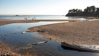
Van Damme State Park consists of about 1,831 acres (7.41 km2) of land in Mendocino County, California, near the town of Little River on State Route 1. It was named for Charles Van Damme (1881–1934), who was born in the area and purchased the land that is now the park with profits from a San Francisco ferry business. On his death, the property became part of the California state park system.

The Salmon River is a 19.6-mile-long (31.5 km) tributary to the Klamath River in western Siskiyou County, California.

The North Coast of California is the region in Northern California that lies on the Pacific coast between San Francisco Bay and the Oregon border. The area is named after the dense redwood forests throughout the region. It commonly includes Mendocino, Humboldt, and Del Norte counties and sometimes includes two counties from the San Francisco Bay area, Marin and Sonoma.

Bear Camp Road is a rugged mountain road traversing the Klamath Mountains in Josephine and Curry counties in the U.S. state of Oregon. Bear Camp Road is a combination of Bureau of Land Management (BLM) Road 34-8-36 starting just south of Galice and United States Forest Service (FS) Road 23, which continues from the 12-mile (19 km) point on 34-8-36 to Agness. The road is named for a camp and viewpoint at the 4,600-foot (1,400 m) summit near the Josephine–Curry county line.
Lawyers Bar was a settlement in Klamath County now Del Norte County, California, United States. It was located on the Middle Fork of the Smith River, at an elevation of 899 feet. It still appeared on maps as of 1922.

Johnsons is an unincorporated community in Humboldt County, California. It is located on the Klamath River 14 miles (23 km) northwest of Weitchpec, at an elevation of 180 feet.
Albeeville is a former settlement in Klamath County, now located in Humboldt County, California. Albeeville was located on Redwood Creek, within an easy day's travel from Fort Gaston. The post office was named for Joseph Porter Albee, its first postmaster, who was murdered by Indians, and the Albeeville post office burned in November 1863.
The Klamath River is a river in southern Oregon and northern California in the United States. This article describes its course.
Elk Camp was an American settlement between Redwood Creek and the Klamath River, fifteen miles northwest of Fort Anderson in modern Humboldt County, California it was formerly located in Klamath County. Elk Camp was a post office from January 31, 1859 to December 19, 1862.

Sawyers Bar is an unincorporated community located on the North Fork Salmon River in unincorporated Siskiyou County, California, not to be confused with a Sawyers or Lawyers Bar in Del Norte County.
Bestville is an unincorporated community in on the North Fork Salmon River in Siskiyou County, California, just downstream from Sawyers Bar. Bestville is located at 41.3007°N 123.1431°W.
Negro Flat was a placer gold mining camp on the Salmon River, now located in Siskiyou County, California. It was located originally in Trinity County, in 1850.
Black Bear is a populated place, originally a gold mining town in Klamath County, now in unincorporated Siskiyou County, California.
Gullion's Bar was a placer gold mining camp on the Salmon River, now located in Siskiyou County, California. It was located originally in Trinity County, in 1850.

Mark W. Bullard, also known as M. W. Bullard, was an American pioneer who established homesteads in Oregon and Washington state. As a young man, he traveled from his family home in Vermont to California and then on to Oregon and Washington. He eventually settled in what is now Pacific County, Washington. He served in the Washington territorial militia during a regional Indian war in the mid-1850s. After the war, he moved to the Goose Lake Valley in south central Oregon. While there, he donated property to establish a new town that became Lakeview, Oregon, the county seat of Lake County. He later returned to his farm in Pacific County, Washington.
The North Fork Salmon River is a 36.9-mile (59.4 km) river in Siskiyou County, California. It joins with the South Fork Salmon River at Forks of Salmon to form the Salmon River, a major tributary of the Klamath River. Originating at English Lakes near 7,322-foot (2,232 m) English Peak in the Salmon Mountains, the North Fork drains about 204 square miles (530 km2) of rugged, forested terrain. The entire river is located within the Klamath National Forest, with the headwaters located in the Marble Mountain Wilderness.
References
- ↑ Hubert Howe Bancroft, History of California, Vol. VI, 1848-1859, The History company, San Francisco, 1888, p.370
- ↑ Theodore Henry Hittell, History of California, Volume 3, N. J. Stone, San Francisco, 1897, p.140
- ↑ P. Wingate Bar River Access; Klamath National Forest website accessed January 17, 2012
