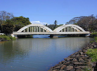
Haleʻiwa is a North Shore community and census-designated place (CDP) in the Waialua District of the island of Oʻahu, City and County of Honolulu. Haleʻiwa is located on Waialua Bay, the mouth of Anahulu Stream. A small boat harbor is located here, and the shore of the bay is surrounded by Haleʻiwa Beach Park and Haleʻiwa Aliʻi Beach Park. Further west from the center of town is Kaiaka State Recreation Area on Kiaka Point beside Kaiaka Bay. As of the 2020 census, the CDP had a population of 4,941. The 2018 estimate was 4,040. It is the largest commercial center on the North Shore of the island. Its old plantation town character is preserved in many of the buildings, making this a popular destination for tourists and residents alike, visiting surfing and diving sites along the north shore.

Hancock is a town in Hancock County, Maine, United States. The population was 2,466 at the 2020 census. Located on the mainland at the head of Frenchman Bay, Hancock has commanding views of Mount Desert Island.
Sullivan is a town in Hancock County, Maine, United States. The population was 1,219 at the 2020 census. The town was named for Daniel Sullivan, an early settler. Colloquially referred to as "Sully" or "the Sullivans"—like many Maine municipalities composed of villages with geographic designations of the town proper—the municipality was incorporated in 1789. Located in the Upper Schoodic Peninsula sub-region of Maine's Downeast Acadia region, the municipality has been known as "Waukeag", "New Bristol", and later Sullivan; and once included the nearby communities of Hancock, Sorrento, and what would later be Township 7, South & Middle Districts. Once home to abundant granite quarries, the town of Sullivan is now a residential community for nearby Ellsworth and Mount Desert Island. Located along U.S. Route 1, the Taunton River, and Hog Bay, Sullivan is home to a reversing tidal falls and many scenic turnouts that dot the Schoodic National Scenic Byway along the Upper Schoodic Peninsula.

Meredith is a census-designated place (CDP) and the main village in the town of Meredith in Belknap County, New Hampshire, United States. The population was 2,527 at the 2020 census, out of 6,662 in the entire town of Meredith.

Wolfeboro is a census-designated place (CDP) in the town of Wolfeboro in Carroll County, New Hampshire, United States. It consists of the main village of Wolfeboro within the town, as well as the smaller village of Wolfeboro Falls. The population of the CDP was 3,300 at the 2020 census, out of 6,416 in the entire town of Wolfeboro.
Gorham is a census-designated place (CDP) and the main village in the town of Gorham in Coos County, New Hampshire, United States. The population of the CDP was 1,851 at the 2020 census, out of 2,698 people in the entire town of Gorham.
Newport is a census-designated place (CDP) comprising the main village and surrounding rural land in the town of Newport, Sullivan County, New Hampshire, United States. The population of the CDP was 4,735 at the 2020 census, out of 6,299 in the entire town.

Goffstown is a census-designated place (CDP) and the main village in the town of Goffstown in Hillsborough County, New Hampshire, United States. The population of the CDP was 3,366 at the 2020 census, out of 18,577 in the entire town.
Bar Harbor is a census-designated place (CDP) in the town of Bar Harbor in Hancock County, Maine, United States. The CDP population was 2,552 at the 2010 census, out of a population of 5,235 in the town of Bar Harbor as a whole.

Greenwich is a census-designated place (CDP) in Fairfield County, Connecticut, United States. It is one of several CDPs within the town of Greenwich and corresponds to the historic municipal center of the town and surrounding residential and commercial areas. As of the 2010 census, the population of the Greenwich CDP was 12,942, out of 61,171 in the entire town.
Blue Hill is a census-designated place (CDP) in the town of Blue Hill in Hancock County, Maine, United States. The CDP population was 943 as per the 2010 census, out of a population of 2,686 in the town of Blue Hill as a whole.
Castine is a census-designated place (CDP) in the town of Castine in Hancock County, Maine, United States. The CDP population was 1,029 at the 2010 census, out of 1,366 people in the town as a whole.
Southwest Harbor is a census-designated place (CDP) in the town of Southwest Harbor in Hancock County, Maine, United States. The CDP population was 720 at the 2010 census, out of 1,764 people in the town as a whole.

Damariscotta is a census-designated place (CDP) comprising the main village of the town of Damariscotta in Lincoln County, Maine, United States. The population was 1,142 at the 2010 census, out of 2,218 in the entire town. In the 2000 census, the village was part of the Damariscotta-Newcastle CDP.
Newcastle is a census-designated place (CDP) comprising the main village of the town of Newcastle in Lincoln County, Maine, United States. The population was 667 at the 2010 census, out of 1,752 in the entire town. In the 2000 census, the village was part of the Damariscotta-Newcastle CDP.

Oakland is a census-designated place (CDP) comprising the main population center in the town of Oakland in Kennebec County, Maine, United States. The population was 2,602 at the 2010 census, out of 6,240 in the entire town of Oakland.

Camden is a census-designated place (CDP) comprising the main village in the town of Camden in Knox County, Maine, United States. The population was 3,570 at the 2010 census, out of 4,850 in the entire town of Camden.

Boothbay Harbor is a census-designated place (CDP) comprising the densely populated center of the town of Boothbay Harbor in Lincoln County, Maine, United States. The population was 1,086 at the 2010 census, down from 1,237 at the 2000 census.

Waldoboro is a census-designated place (CDP) comprising the central village in the town of Waldoboro in Lincoln County, Maine, United States. The population was 1,300 at the 2020 census, out of 5,075 people in the entire town of Waldoboro.

Wiscasset is a census-designated place (CDP) comprising the primary settlement in the town of Wiscasset in Lincoln County, Maine, United States. The population was 1,232 at the 2020 census, out of 3,732 people in the entire town. Wiscasset is the county seat of Lincoln County.


