East Hancock, Maine

Last updated
East Hancock, Maine
USA Maine location map.svg
Red pog.svg
East Hancock, Maine
Location within the state of Maine
Coordinates: 44°56′56″N68°08′31″W / 44.94889°N 68.14194°W / 44.94889; -68.14194
Country United States
State Maine
County Hancock
Area
  Total481.2 sq mi (1,246.4 km2)
  Land444.3 sq mi (1,150.6 km2)
  Water37.0 sq mi (95.8 km2)
Elevation
469 ft (143 m)
Population
 (2020)
  Total85
Time zone UTC-5 (Eastern (EST))
  Summer (DST) UTC-4 (EDT)
Area code 207
FIPS code 23-20405
GNIS feature ID582456

East Hancock is an unorganized territory in Hancock County, Maine, United States. The population was 85 at the 2020 census. [1]

Contents

Geography

According to the United States Census Bureau, the unorganized territory has a total area of 481.2 square miles (1,246.4 km2), of which 444.3 square miles (1,150.6 km2) is land and 37.0 square miles (95.8 km2) (7.68%) is water.

The territory consists of thirteen townships located along the northern and eastern border of the county.

Demographics

Historical population
CensusPop.Note
1970 20
1980 44120.0%
1990 40−9.1%
2000 7382.5%
2010 9428.8%
2020 85−9.6%
U.S. Decennial Census [2]

As of the census [3] of 2000, there were 73 people, 32 households, and 18 families residing in the unorganized territory. The population density was 0.2 inhabitants per square mile (0.077/km2). There were 580 housing units at an average density of 1.3 per square mile (0.50/km2). The racial makeup of the unorganized territory was 97.26% White, 1.37% Native American, and 1.37% from two or more races.

There were 32 households, out of which 18.8% had children under the age of 18 living with them, 53.1% were married couples living together, 3.1% had a female householder with no husband present, and 43.8% were non-families. 34.4% of all households were made up of individuals, and 15.6% had someone living alone who was 65 years of age or older. The average household size was 2.28 and the average family size was 2.83.

In the unorganized territory the population was spread out, with 17.8% under the age of 18, 6.8% from 18 to 24, 20.5% from 25 to 44, 38.4% from 45 to 64, and 16.4% who were 65 years of age or older. The median age was 48 years. For every 100 females, there were 92.1 males. For every 100 females age 18 and over, there were 93.5 males.

The median income for a household in the unorganized territory was $31,875, and the median income for a family was $42,500. Males had a median income of $32,083 versus $12,083 for females. The per capita income for the unorganized territory was $18,156. There were no families and 2.8% of the population living below the poverty line, including no under eighteens and 13.3% of those over 64.

Related Research Articles

<span class="mw-page-title-main">Franklin, Maine</span> Town in the state of Maine, United States

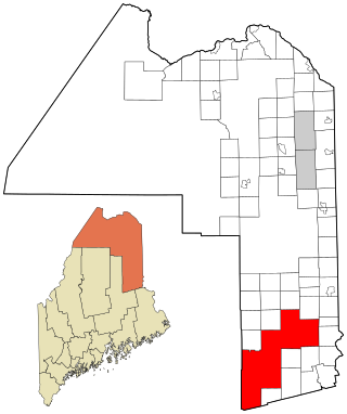
Franklin is a town in Hancock County, Maine, United States. The population was 1,567 at the 2020 census. The town's namesake is Benjamin Franklin.

<span class="mw-page-title-main">Central Aroostook, Maine</span> Unorganized territory in Maine, United States

Central Aroostook is an unorganized territory in Aroostook County, Maine, United States. The population was 164 at the 2020 census.

<span class="mw-page-title-main">Connor, Maine</span> Unorganized territory in Maine, United States

Connor is an unorganized territory (township) in Aroostook County, Maine, United States. The population was 418 at the 2020 census. It is the location of a former Nike missile site and the Blotner Radar Site.

<span class="mw-page-title-main">Northwest Aroostook, Maine</span> Unorganized territory in Maine, United States

Northwest Aroostook is an unorganized territory in Aroostook County, Maine, United States. The population was 12 at the 2020 census.

<span class="mw-page-title-main">South Aroostook, Maine</span> Unorganized territory in Maine, United States

South Aroostook is an unorganized territory in Aroostook County, Maine, United States. The population was 579 at the 2020 census.

<span class="mw-page-title-main">Square Lake, Maine</span> Unorganized territory in Maine, United States

Square Lake is an unorganized territory in Aroostook County, Maine, United States. The population was 706 at the 2020 census.

<span class="mw-page-title-main">East Central Franklin, Maine</span> Unorganized territory in Maine, United States

East Central Franklin is an unorganized territory in Franklin County, Maine, United States. The population was 805 at the 2020 census.

South Franklin is an unorganized territory in Franklin County, Maine, United States. The population was 60 at the 2020 census.

Wyman is an unorganized territory in Franklin County, Maine, United States. The population was 82 at the 2020 census. It is designated as Township 4 Range 3 of Bingham's Kennebec Purchase.

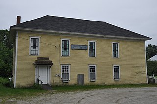
Central Hancock, also known as Fletchers Landing, is an unorganized territory (township) in Hancock County, Maine, United States. The population was 132 at the 2020 census. The territory is designated as Township 8 Southern Division.

Milton is an unorganized territory (township) in Oxford County, Maine, United States. The population was 150 at the 2020 census. The township was formerly a plantation that surrendered its organization in 1939.

<span class="mw-page-title-main">South Oxford, Maine</span> Unorganized territory in Maine, United States

South Oxford is an unorganized territory located in Oxford County, Maine, United States. The population was 591 at the 2020 census. The unorganized territory encompasses the areas designated under state law as Albany Township, Mason Township, and Batchelder's Grant. Albany and Mason were formerly incorporated as towns. Albany disincorporated in 1937 while Mason disincorporated in 1935.

East Central Penobscot is an unorganized territory in Penobscot County, Maine, United States. The population was 308 at the 2020 census.

Kingman is an unorganized territory (township) in Penobscot County, Maine, United States. The population was 137 at the 2020 census.

North Penobscot is an unorganized territory in Penobscot County, Maine, United States. The population was 405 at the 2020 census.

Prentiss is an unorganized territory (township) in Penobscot County, Maine, United States. The township was named for Henry Prentiss, an early landowner. The population was 169 at the 2020 census.

<span class="mw-page-title-main">Blanchard, Maine</span> Unorganized territory in Maine, United States

Blanchard is an unorganized territory (township) in Piscataquis County, Maine, United States. The population was 91 at the 2020 census.

<span class="mw-page-title-main">Northwest Piscataquis, Maine</span> Unorganized territory in Maine, United States

Northwest Piscataquis is an unincorporated area in Piscataquis County, Maine, United States. The population was 134 at the 2020 census.

<span class="mw-page-title-main">Southeast Piscataquis, Maine</span> Unorganized territory in Maine, United States

Southeast Piscataquis, also known as Orneville, is an unincorporated area (township) in Piscataquis County, Maine, United States. The population was 487 at the 2020 census.

East Central Washington is an unorganized territory in Washington County, Maine, United States. The population was 724 at the 2020 census.

References

  1. "Census - Geography Profile: East Hancock UT, Hancock County, Maine" . Retrieved March 19, 2022.
  2. "Census of Population and Housing". Census.gov. Retrieved June 4, 2015.
  3. "U.S. Census website". United States Census Bureau . Retrieved 2008-01-31.