Woodstock Quartz Monzonite

Last updated
Woodstock Quartz Monzonite
Stratigraphic range: Silurian or Ordovician
Woodstock quartz monzonite closeup.jpg
Photographed on a boulder in Granite, Maryland
Typeigneous
Area~400 Ha
Lithology
Primary monzonite
Location
Region Piedmont of Maryland
Country United States
ExtentWestern Baltimore County
Type section
Named for Woodstock, Maryland
Named byWilliams and Darton, 1892 [1]

The Woodstock Quartz Monzonite is a Silurian or Ordovician quartz monzonite pluton in Baltimore County, Maryland. It is described as a massive biotite-quartz monzonite [2] which intrudes through the Baltimore Gneiss at a single locality surrounding the town of Granite, Maryland.

Contents

The extent of this intrusion was originally mapped in 1892 [1] as the "Woodstock granite". It was given its current name in 1964 by C. A. Hopson. [3] Hopson grouped the Woodstock Quartz Monzonite with the Ellicott City Granodiorite and the Guilford Quartz Monzonite as "Late-kinematic intrusive masses."

Woodstock granite has been used in the Capitol Building, the Library of Congress, and in buildings in Baltimore. [4]

Description

Inclusion (Xenolith) of Baltimore Gneiss in a wall of Waltersville Quarry (c. 1895.) Gneiss Inclusion in Granite Plate XLI Keyes 1895.jpg
Inclusion (Xenolith) of Baltimore Gneiss in a wall of Waltersville Quarry (c. 1895.)
Polished slab from one of the quarries in Granite (1898). Width is about 10.7 cm. Granite PlateXIII MD Geological Survey Volume 2.jpg
Polished slab from one of the quarries in Granite (1898). Width is about 10.7 cm.
Photomicrograph of the Woodstock Quartz Monzonite. Field is about 0.85 cm, under crossed polarized light (1898) Photomicrograph granite PlateXVII Fig1 MD Geological Survey Volume 2.jpg
Photomicrograph of the Woodstock Quartz Monzonite. Field is about 0.85 cm, under crossed polarized light (1898)

The Woodstock Quartz Monzonite was described in 1898 as "perhaps the best granite in Maryland for general building purposes" by Edward B. Mathews of the Maryland Geological Survey. [5] Mathews described the mapped extent of the granite and inclusions of gneiss within it as follows:

The granite mass as indicated by the map forms a more or less oval, isolated area of granite extending scarcely two miles northeast and southwest and a mile northwest and southeast. Although so small, it is one of the most important economic areas within the state. This mass of granite, which is evidently intruded into the gneisses, is entirely enveloped by them and sends no dikes or apophyses into the surrounding rock. That the gneiss is really older than the granite is shown by the great number of inclusions found within the latter. These are chiefly of gneiss, and they occur often in huge irregular blocks six to eight or even ten feet in size, showing narrow rims due to contact metamorphism. They are beautifully puckered and wrinkled and being much richer in ferro-magnesian silicates than the granite itself, their irregular outlines contrast sharply with the lighter background.

Mathews described the granite itself as follows:

The appearance of the Woodstock granite is well represented in (the polished slab shown at right) which reproduces the polished surface in natural size. The color of the rock is bright gray, with something of a luster imparted by the quartz and the unaltered feldspars, the latter often giving an additional faint pink tone. The mica occurs in evenly disseminated fine black flakes which emphasize the grain of the rock and only slightly subdue the bright fresh aspect of the stone. The size of the constituent grains which varies from 0.05-0.2 inches in length, and from 0.01-0.10 inches in breadth, for quartz and feldspar, is little marred by the less resistant mica wearing away and leaving small depressions, that are scarcely discernible to the naked eye. The polished surfaces, such as are represented in (the same figure), are darker than the rough or ashlar finished stone.

Hopson [3] reported the chemical composition (by %) of the Woodstock Quartz Diorite from the "Sylvan Dell Quarry" (probably the Waltersville Quarry) in Granite, Maryland, as follows:

Chemical%Chemical%
SiO271.01CaO2.32
TiO20.30Na2O3.59
Al2O314.46K2O4.38
Fe2O31.17H2O+0.62
FeO1.44H2O0.03
MnO0.04CO20.10
MgO0.70P2O50.12

Early quarrying

The Walters/Blunt family of Waltersville (later Granite, Maryland) "founded the local quarrying industry circa 1820." [6]

The 1898 account of Edward B. Mathews of the Maryland Geological Survey [5] of the quarries at Granite (formerly known as Waltersville) begins with boulders attracting the attention of "several enterprising men from New Hampshire," (Sweatt, Putney, and Riddle) who commenced quarrying operations about 1832-33, and supplied stone to the Baltimore and Ohio Railroad. He continued:

Although prospecting has been carried on ever since, only two ledge quarries have been discovered, viz.: the "Waltersville" and "Fox Rock." The former is the principal one, and was at first called the "Branch." This rock developed into a fine ledge, surpassing all the granite around in quantity, quality and easy access, so that all the boulders in which Sweatt, Putney and Riddle were interested were at once abandoned. After working it for a year or two Putney and Riddle obtained a lease of this quarry for twenty years in August, 1835, from the owner, Captain Alexander Walters, to whose family this quarry has belonged for more than a century. It is called in the lease and is still known as the Waltersville quarry, although the name of the village of Waltersville was changed to Granite about 1873-74, when the first post-office at the place was established. The lessees went to work vigorously, and besides many other improvements, built a railroad two miles long to connect with the Baltimore and Ohio at Putney and Riddle's bridge, about one mile east of Woodstock. Their first contract of importance was furnishing stone for the Baltimore Custom House. They, however, continued the business only a few years. Extravagance and mismanagement caused the failure, and they were succeeded by Edward Green and Joshua B. Sumwalt, under the firm-name of Green & Sumwalt. The senior partner dying about 1849, he was succeeded by his son Frederick, and the firm became Sumwalt & Green, who conducted the business until 1865, when Attwood Blunt, whose wife owned the property, took charge and continued the business until 1871, when the quarry was leased to Ansley Gill and James McMahon. After a lapse of about sixteen years, the firm was dissolved by the death of McMahon. Mr. Gill continued the business alone for a short while, when he associated with him Wm. H. Johnson, of Baltimore, and they soon after formed with George Mann, Hugh Hanna, Messrs. Grey & Sons, of Philadelphia, and Mr. Hamilton of Baltimore, a joint stock company, calling it the Guilford and Waltersville Granite Co. This company is now (in 1898) conducting the business.

"The two largest quarries were Waltersville and Fox Rock. These and smaller quarries counted hundreds of stonecutters among their employees." The quarries near Granite were "most active after 1875." [6]

Images of the quarries

Age

In 1966, G. W. Wetherill reported a radiometric date of the Woodstock Quartz Monzonite of 420 +/-50 Ma (Silurian). [7] In 1998, A. A. Drake reported an age of 444 Ma (Ordovician), [8] and suggested it may be comagmatic with the Guilford Quartz Monzonite.

Use in construction

Woodstock granite can be found in the United States Capitol, Thomas Viaduct, "the Library of Congress, the inner walls of the Washington Monument, the Old Patent Office, and the Baltimore Custom House." [6]

See also

Related Research Articles

Xenolith

A xenolith is a rock fragment that becomes enveloped in a larger rock during the latter's development and solidification. In geology, the term xenolith is almost exclusively used to describe inclusions in igneous rock entrained during magma ascent, emplacement and eruption. Xenoliths may be engulfed along the margins of a magma chamber, torn loose from the walls of an erupting lava conduit or explosive diatreme or picked up along the base of a flowing body of lava on the Earth's surface. A xenocryst is an individual foreign crystal included within an igneous body. Examples of xenocrysts are quartz crystals in a silica-deficient lava and diamonds within kimberlite diatremes. Xenoliths can be non-uniform within individual locations, even in areas which are spatially limited, e.g. rhyolite-dominated lava of Niijima volcano (Japan) contains two types of gabbroic xenoliths which are of different origin - they were formed in different temperature and pressure conditions.

Guilford, Maryland Unincorporated community in Maryland, United States

Guilford is an unincorporated community located in Howard County in the state of Maryland. The location is named after the Guilford Mill. Guilford is near Kings Contrivance, one of the nine "villages" of Columbia.

Quartz monzonite Type of igneous rock

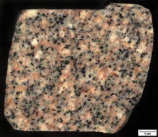
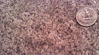
Quartz monzonite is an intrusive, felsic, igneous rock that has an approximately equal proportion of orthoclase and plagioclase feldspars. It is typically a light colored phaneritic (coarse-grained) to porphyritic granitic rock. The plagioclase is typically intermediate to sodic in composition, andesine to oligoclase. Quartz is present in significant amounts. Biotite and/or hornblende constitute the dark minerals. Because of its coloring, it is often confused with granite, but whereas granite contains more than 20% quartz, quartz monzonite is only 5–20% quartz. Rock with less than five percent quartz is classified as monzonite. A rock with more alkali feldspar is a syenite whereas one with more plagioclase is a quartz diorite. The fine grained volcanic rock equivalent of quartz monzonite is quartz latite.

Little Cottonwood Canyon

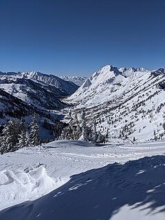
Little Cottonwood Canyon lies within the Wasatch-Cache National Forest along the eastern side of the Salt Lake Valley, roughly 15 miles from Salt Lake City, Utah. The canyon is part of Granite, a CDP and "Community Council" designated by Salt Lake County. The canyon is a glacial trough, carved by an alpine glacier during the last ice age, 15,000 to 25,000 years ago. A number of rare and endemic plant species are found in the canyon's Albion Basin. Mountain goats inhabit the surrounding mountains.

Granodiorite Type of coarse grained intrusive igneous rock

Granodiorite is a coarse-grained (phaneritic) intrusive igneous rock similar to granite, but containing more plagioclase feldspar than orthoclase feldspar.

Monzonite Igneous intrusive rock with low quartz and equal plagioclase and alkali feldspar

Monzonite is an igneous intrusive rock, formed by slow cooling of underground magma that has a moderate silica content and is enriched in alkali metal oxides. Monzonite is composed mostly of plagioclase and alkali feldspar.

Geology of Guernsey

Guernsey has a geological history stretching further back into the past than most of Europe. The majority of rock exposures on the Island may be found along the coastlines, with inland exposures scarce and usually highly weathered. There is a broad geological division between the north and south of the Island. The Southern Metamorphic Complex is elevated above the geologically younger, lower lying Northern Igneous Complex. Guernsey has experienced a complex geological evolution with multiple phases of intrusion and deformation recognisable.

Granite, Maryland Unincorporated community in Maryland, United States

Granite is an unincorporated community in Baltimore County, Maryland, United States. Originally known as Waltersville, it was renamed Granite in recognition of its principal product. The village was the center of this industry, which during its peak in the late 19th century provided building materials for major projects throughout the eastern seaboard.

Granite Historic District Historic district in Maryland, United States

Granite Historic District is a national historic district in Granite, Baltimore County, Maryland, United States. It comprises the focus of a rural quarrying community located in the Patapsco Valley of western Baltimore County, Maryland. It includes two churches, a school, a social hall, former commercial buildings, and houses and outbuildings, representing the period from the initial settlement of the area about 1750 through the early 20th century, when the village achieved its present form. The district also includes the former Waltersville quarry, one of two major granite operations in the region during the period. Granite from the Waltersville and Fox Rock quarries was utilized in construction of the Baltimore & Ohio Railroad in the 1830s, and later in such projects as the Library of Congress, old Treasury Building, and parts of the inner walls of the Washington Monument in Washington, D.C., and numerous other projects in Baltimore city and county.

Milford pink granite

Milford pink granite, also known as Milford granite or Milford pink is a Proterozoic igneous rock located in and around the town of Milford, Massachusetts, covering an area of approximately 39 square miles (100 km2), as mapped by the USGS. It is also sometimes referred to as Braggville granite, for several quarries in the neighboring village of Braggville, Massachusetts.

Sumwalt is a surname derived as a variation of the surname Zumwalt.

Guilford Quartz Monzonite

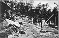
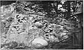
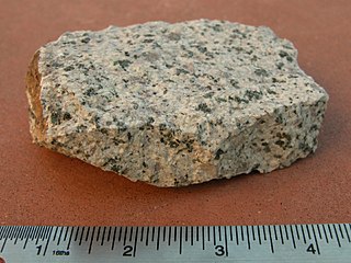
The Guilford Quartz Monzonite is a Silurian or Ordovician quartz monzonite pluton in Howard County, Maryland. It is described as a biotite-muscovite-quartz monzonite which occurs as discontinuous lenticular bodies which intrude mainly through the Wissahickon Formation (gneiss).

Ellicott City Granodiorite

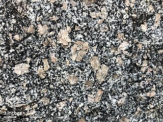
The Ellicott City Granodiorite is a Silurian or Ordovician granitic pluton in Howard and Baltimore Counties, Maryland. It is described as a biotite granodiorite along the margin of the intrusion which grades into a quartz monzonite in its core. It intrudes through the Wissahickon Formation and the Baltimore Gabbro Complex.

Baltimore Gabbro Complex is a hypersthene gabbro with subordinate amounts of olivine gabbro, norite, anorthositic gabbro, and pyroxenite. Igneous minerals and textures are well preserved in some rocks, and other rocks exhibit varying degrees of alteration and recrystallization with a new metamorphic mineral assemblage.

Port Deposit Gneiss

The Port Deposit Gneiss is a Paleozoic gneiss formation in Cecil County, Maryland. It is described as a "Moderately to strongly deformed intrusive complex, chiefly composed of quartz diorite gneiss. Rock types include gneissic biotite-quartz diorite, hornblende-biotite-quartz diorite, and biotite granodiorite, with minor amounts of quartz monzonite and hornblende-quartz diorite. Moderate protoclastic foliation grades into strong cataclastic shearing." It intrudes into the Volcanic Complex of Cecil County.

Oella Formation

The Oella Formation is a Late Proterozoic or early Cambrian schist in Howard and Baltimore Counties, Maryland. It is described as "Medium-grained biotite-plagioclase-muscovite-quartz schist, locally garnetiferous, interlayered on a centimeter to decimeter scale with fine-grained biotite-plagioclase-quartz gneiss, commonly bearing muscovite but less commonly garnet."

The geology of Wisconsin includes Precambrian crystalline basement rock over three billion years old. A widespread marine environment during the Paleozoic flooded the region, depositing sedimentary rocks which cover most of the center and south of the state.

Baltimore Gneiss

The Baltimore Gneiss is a Precambrian geological formation in the Piedmont region of Maryland, Pennsylvania, and Delaware.

Lilesville Granite Body of granitic rock

The Lilesville Granite, also referred to as the Lilesville pluton, is a ring-shaped body of granitic rock that spans about 94 square miles (240 km2) in Anson, Richmond, and Montgomery Counties in southern North Carolina.

Guilford Quarry Pratt Through Truss Bridge Bridge in Guilford, Maryland

The Guilford Quarry Pratt Through Truss Bridge at Guilford, Maryland is a single-span, metal truss, railroad bridge

References

  1. 1 2 Williams, G.H., and Darton, N.H., 1892, Geologic map of Baltimore and vicinity: U.S. Geological Survey, Map to accompany "Guide to Baltimore".
  2. USGS Mineral Resources On-Line Spatial Data
  3. 1 2 Hopson, C. A., 1964, The crystalline rocks of Howard and Montgomery Counties: Maryland Geological Survey County Report, 337 p., (Reprinted from Cloos, Ernst, and others, "Geology of Howard and Montgomery Counties," p. 27-215)
  4. Park, John R (2002). Maryland mining heritage guide: including Delaware and the District of Columbia. Miami, FL: Stonerose Pub. Co. p. 35. ISBN   0970669720.
  5. 1 2 Maryland Geological Survey Volume 2, 1898, The Johns Hopkins Press, Baltimore.
  6. 1 2 3 Park, John R (2002). Maryland mining heritage guide: including Delaware and the District of Columbia. Miami, FL: Stonerose Pub. Co. pp. 32–33. ISBN   0970669720.
  7. Wetherill, G.W., Tilton, G.R., Davis, G.L., Hart, S.R., and Hopson, C.A., 1966, Age measurements in the Maryland Piedmont: Journal of Geophysical Research, v. 71, p. 2139-2155.
  8. Drake, A.A., Jr., 1998, Geologic map of the Kensington quadrangle, Montgomery County, Maryland: U.S. Geological Survey Geologic Quadrangle Map, GQ-1774, scale 1:24,000