
Ash is a village and civil parish in the Dover district of east Kent about three miles west of Sandwich.

Sutton is a small village and civil parish that is located near Peterborough, in the North-West of Cambridgeshire, England in the East Midlands. Situated about 5.7 miles from Peterborough and approximately half a mile south of the A47 road.

Cratfield is a village in northern Suffolk, England. "It has a population of 292 according to the 2011 census." Neighbouring villages include Laxfield, Metfield, Cookley, Huntingfield, Heveningham. The nearest town, Halesworth, is approximately 6.7 miles (10.7 km) away. Southwold is a popular, nearby coastal town. The market town of Framlingham is also close by.

Lorton, a parish in the district of Allerdale of the English county of Cumbria, consists of two adjacent villages: Low Lorton and High Lorton. Both nestle at the northern end of the Vale of Lorton, surrounded by fells such as Grasmoor, Hopegill Head and Whiteside. They are about 4 miles from Cockermouth, which gives access to the main A66 road. Other nearby places include Loweswater and Brigham.

Holmer and Shelwick is a civil parish in Herefordshire, England. It is immediately to the north of the Hereford and includes Holmer, Munstone, Shelwick and Shelwick Green. It is surrounded by rural fields, however the amenities of Hereford are very close by.

East Langton is a village and civil parish in the Harborough district of Leicestershire, England.

Badingham is a civil parish in the East Suffolk district of eastern England, in the county of Suffolk. It is situated 21.8 miles north east of Ipswich, 35 miles away from Norwich and 13 miles away from the Coast. With the road "A1120" slicing through the middle of the parish. Badingham's name is Anglo-Saxon and means "the farmstead of Beada's people". Badingham contains a significant number of farms, sparse amount of housing, numerous B&Bs as well as St. Johns Church.

Birling is a village and civil parish in the Tonbridge and Malling district of Kent, England, about seven miles west of Maidstone. According to the 2001 census it had a population of 430 increasing to 437 at the 2011 Census: 224 male and 213 female. It is south-west of the nearby town of Snodland and 37 miles away from the capital.
Darenth is a village and civil parish in the Borough of Dartford, Kent, England. It is located 3.4 miles south east of Dartford and 4.6 miles north east of Swanley.

Parham is a village and civil parish in the East Suffolk district of Suffolk in eastern England. Located seven miles north of Woodbridge, in 2005 it had a population of 300, reducing to 263 at the 2011 census and according to the 2011 census there were 129 males and 134 females living at this time.

Rogate is a village and civil parish in the Chichester district of West Sussex, England, in the Western Rother valley. The village is on the A272 road 5.6 miles (9.0 km) west of Midhurst and 5 miles (8.0 km) east of Petersfield, Hampshire. The civil parish includes the villages of Rogate and Rake and the hamlets of Haben, Fyning, Hill Brow, Langley, Durford, Wenham, Durleighmarsh and Terwick Common.

Dutton is a civil parish and village within the unitary authority of Runcorn and Chester in the ceremonial county of Merseyside, England, about two miles (3 km) east of Runcorn. Dutton is on the River Weaver and was home to Dutton Hall, built in 1513 and moved to Sussex in the 1930s. Dutton Viaduct, a viaduct of 20 arches, each 63 feet in span, and 60 feet high, carries the Grand Junction railway over Dutton Bottom, across the valley of the Weaver.

Brent Eleigh is a village and civil parish in the Babergh district of Suffolk, England. Located between Hadleigh and Lavenham, in 2005 it had a population of 180 reducing to 174 at the 2011 Census.

Langdon is a civil parish in the Dover district of Kent, England, and contains the villages of East Langdon and West Langdon, and the hamlets of Martin and Martin Mill. Langdon was the site of Langdon Abbey which was dissolved in 1535.

Newborough is a village and a civil parish in the Peterborough district, Cambridgeshire, England. Newborough is situated 7.62 km (4.74 mi) North of Peterborough. Newborough has a population of 1,670 according to the 2011 census

Great Livermere is a village and civil parish in the West Suffolk district of Suffolk in eastern England. It is located around four miles north-east of the borough's largest town Bury St Edmunds.

Pettistree is a small village and a civil parish in the East Suffolk district, in the English county of Suffolk. According to the 2011 Census, Pettistree had a population of 194 people and is set in around 1,800 acres of farmland. The village has many footpaths and country lanes surrounding it. Being only one mile from the larger village of Wickham Market, Pettistree uses many of their resources; such as the Post Office, Medical and Resource Centre and Children's Play Area. The Primary School situated in Wickham Market also serves the younger children of Pettistree. However, senior children are required to travel 7 miles to Thomas Mills High School which is situated in Framlingham.

Stapleford is a village and civil parish of 134 acres (54 ha) on the A119 road, in the East Hertfordshire district, in the county of Hertfordshire, England. Stapleford is located between Waterford and Watton-at-Stone in the Beane valley; the little river was forded at this point, giving rise to the village. Stapleford's parish church is St Mary's Church. Beane is a hamlet of Stapleford.

Skelsmergh is a small village and former civil parish, now in the parish of Skelsmergh and Scalthwaiterigg, in South Lakeland in rural Cumbria, England, about 4 miles (6.4 km) north of Kendal, on the A6 road.
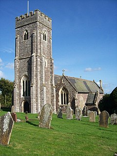
Shobrooke is a village, parish and former manor in Devon, England. The village is situated about 1 1/2 miles north-east of Crediton. It is located close to Shobrooke park. The river Shobrooke Lake flows through the village. It had a population of 537 according to the 2011 census. The name Shobrooke is derived from the old English words of succa and brōc, and translates as goblin brook.


